
Brand (Saxon Switzerland)
| fire | ||
|---|---|---|
.jpg) View from Waltersdorf to the fire |
||
| height | 317 m | |
| location | Saxony ( Germany ) | |
| Mountains | Elbe Sandstone Mountains | |
| Coordinates | 50 ° 57 '22 " N , 14 ° 7' 36" E | |
|
||
| Type | Rock plateau | |
| rock | Sandstone | |
| particularities | Mountain chalet with hostel and national park information | |

The fire is a rock plateau located 3.1 km south of Hohnstein in Saxon Switzerland , which is 317.4 m above sea level. NHN and 177 meters above the Polenz flowing directly below . The fire prospect is one of the most famous views in Saxon Switzerland.
Surname
The name of the lookout rock is derived from earlier forest fires in the surrounding forest areas.
history
Although the fire on the 1780 incurred Miles leaves are not yet registered, must be assumed to be much prior knowledge of the prospect, as the south of the Brands subsequent cliff of Frinzberges in the 15th century as a watch tower and bailey of the castle Hohnstein was used. The date “1751” is engraved on the descent from Brand to Tiefen Grund.
The first (tourist) mention under the name Brand goes back to Carl Heinrich Nicolai , who wrote in 1801: Not so far from here is a place called the fire; the way has to go there now. This is another point of a rock on the edge of a deep valley. It is said to have got its name from the fact that the heather was found burning on it several times.
A touristic development took place comparatively early, as the vantage point was on the classic route of the Malerweg from Liebethaler Grund via the bastion to Saxon Switzerland. One of the artists who demonstrably stayed on the fire was the writer Moritz August von Thümmel . He left the inscription in the Thümmelgrotte near the view:
It is good for me that I still like
the lure of nature without being spoiled .
Such a region, friend, reconciles
me with the rest of the world.
One gets tired of life
with all the ebb and flow of the city,
But here, busy or idle
, nobody gets tired of his existence.
In 1835 there were reports of rustic seats, a small hut and a little mother who wandered here every day and sold refreshments . In 1856 the forest administration built a log cabin. In 1877 the number of visitors had grown to such an extent that a stone building was erected (increased in 1899). In 1893 a large lodging house was also built. The historic building ensemble is used today as the “Brand-Baude” inn, hiking hostel and information point for the Saxon Switzerland National Park .
view
From the fire there is an outstanding view to the east, south and west of large parts of Saxon Switzerland to the Eastern Ore Mountains . In the mid-19th century, the view was described as follows:
- One of the richest landscapes in Saxon Switzerland lies spread out before us on this point. (...) On the right you can see the rocks near Rathen with the bastion , the friendly Wehlen and a gleaming arch of the Elbe pushed into the distance, then the Lilienstein and Königstein , behind which an area covered with countless villages extends, over which in the peaks of Wilisch , Geisings , Sattelberg and other heights of the Ore Mountains rise up in the blue distance . Further to the left, the Pfaffenstein , the Gohrisch , the Nollendorfer Höhe with the chapel, the Schneeberg , the Kuppelberge, the Zirkelstein stand out from the numerous mountains . You can hardly see the Zschirnstein from any other point of view as beautifully as from here. The view closes to the left with the Great Winter Mountains and Schrammsteine , behind which the Rosenberg rises.
Because of its view, the fire is one of the main hiking destinations in Upper Saxon Switzerland.

Access
The classic access to the fire is from Hohnstein via the so-called Brandstrasse , an approximately 2.5 km long paved road. From the Tiefen Grund (Waitzdorfer Bach) to the east, around 850 steps, known as fire steps, lead up to the fire. The wooden and steel stairs, which follow one another at loose intervals, overcome about 150 meters in altitude. Another access leads from the western Polenztal from the Waltersdorfer Mühle over the Schulzengrund to the Brandstraße. The path over Brandstrasse and the fire steps is part of the Malerweg , the main hiking trail in Saxon Switzerland.
Conservation and Tourism
The fire has been part of the Saxon Switzerland National Park since 1990. It is located in the core zone of the national park, in which particularly strict protection regulations apply. The historic log house has housed an information point for the national park administration since 2006. The focus here is on historical features from the national park region.
The fire was visited by around 40,500 hikers a year in the late 1990s.
Rockclimbing
The Brand is also the namesake of the Brand climbing area of the same name , which includes around 80 climbing peaks between Hohnstein and Kohlmühle. Right below the view is the Brandscheibe climbing rock with several trails of difficulty V to VIIIc (Saxon).
gallery

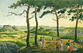
"On the Fire" - drawing by Carl August Richter (1818)
The fire prospect drawn by Ludwig Richter (1820)

View of the Brandbaude (around 1910)

historical log house with the fire hut in the background

Lodging house
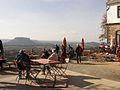
Viewing terrace on the fire with the Lilienstein in the background
.jpg)
.jpg)


Individual evidence
- ↑ http://www.czippe.homepage.t-online.de/HomepageClassic01/wavo5.htm
- ↑ Nicolai 1801, p. 38
- ↑ http://www.czippe.homepage.t-online.de/HomepageClassic01/wavo5.htm
- ↑ http://www.brand-baude.de/
- ↑ Ferdinand Thal: Guide to Saxon Switzerland. Verlag HH Grimm, Dresden 1846, p. 34
- ↑ https://www.wanderpfade.de/?wp=745
- ↑ Blockhaus Brand information point. In: nationalpark-saechsische-schweiz.de. Saxon Switzerland National Park Administration, accessed on February 14, 2016 .
- ^ National Park Administration 1998
literature
- Königstein area, Saxon Switzerland (= values of the German homeland . Volume 1). 1st edition. Akademie Verlag, Berlin 1957.
- Wilhelm Lebrecht Götzinger: Schandau and its surroundings or description of the so-called Saxon Switzerland. Bautzen 1804; 2nd edition by Bergersche Buch- und Kunsthandlung, Dresden 1812; Verlag der Kunst, Dresden 2008 (reprint). ISBN 978-3-86530-108-6 .
- Alfred Meiche: Historical-topographical description of the Pirna administration. Baensch Foundation, Dresden 1927; City administration Sebnitz, Sebnitz 1991 (reprint).
- National park administration: Maintenance and development plan for the Saxon Switzerland National Park, part of the path concept. Draft 09/1998.
- Carl Heinrich Nicolai: Guide through Saxon Switzerland. Pinther, Pirna 1801; Hellerau-Verlag, Dresden 1990 (reprint).