
Gohrisch (mountain)
| Gohrisch | ||
|---|---|---|
.jpg) Gohrisch seen from the Papststein |
||
| height | 447.8 m above sea level HN | |
| location | Saxony ( Germany ) | |
| Mountains | Elbe Sandstone Mountains | |
| Coordinates | 50 ° 54 '4 " N , 14 ° 6' 44" E | |
|
||
| Type | Table Mountain | |
| rock | Sandstone level e | |
| Age of the rock | Coniac | |

The Gohrisch (wrongly also Gohrischstein , 447.8 meters) is a table mountain in Saxon Switzerland on the left Elbe . Its name goes back to the Old Sorbian Gora for mountain .
Location and surroundings
The Gohrisch is located about four kilometers southeast of Königstein and about four kilometers south of Bad Schandau in the middle of a plateau ( flatness ) that is dominated by other similar rocky mountains. The surrounding mountains are the Papststein , the Kleinhennersdorfer Stein and the Lasensteine . In terms of tourism, this microregion in Saxon Switzerland is often referred to as the area of stones . At the foot of the Gohrisch there are the small towns of Kurort Gohrisch and Papstdorf , which belong to the Gohrisch community . On the east side there is the soapstone tunnel as a witness of earlier mining attempts . In the immediate vicinity there is a small, overgrown quarry in which basalt was extracted as road gravel.
history
In 1496 the "Gohrischer Stein" was first mentioned in a document. During the Thirty Years War , a weathered rift cave ("Sweden Cave") on the summit served as a short-term refuge for the residents of the area.
The jagged rock plateau has long stood in the way of tourist development of the mountain. In 1846, when the tourist development of the neighboring mountains was already underway, a travel guide noted: “The Gorischstein is very difficult to climb.” It was only when the village of Gohrisch developed into a summer resort from 1869 onwards that the mountain also increasingly became a destination Excursionists. At this time the first small hospitality huts had been in existence on the neighboring mountains Papststein (1858) and Pfaffenstein (1852) for several years.
Under the royal chief forester Emil Grünewald (1842–1892) and with the support of the Mountain Association for Saxon-Bohemian Switzerland , the summit was made accessible in 1886 by three paved paths. Two years later (1888) the Cunnersdorf Beautification Association built a small octagonal shelter on the east side of the summit plateau. Presumably at the end of the 19th century, the first weather vane was set up on the rock of the west outlook, which earned the view the name “weather vane view”.
The refuge at the east prospect fell into disrepair after 1945. The path systems, which were also no longer maintained after the end of the Second World War , were restored in 1955 as part of the national reconstruction project. In 1985 the sixth weather vane was set up on the weather vane lookout. The path systems were also renewed in traditional wooden construction. The dilapidated refuge was rebuilt in 1998 in the same place. The wooden climbing aids for the ascent were largely replaced by metal ladders, steps and gratings around 2010/2011.
Geology and mining
_an_der_Ostseite_des_Berges_(01-2).jpg)
The Gohrisch consists of sandstones of grades d and e, which are classified in the geological time scale in the grades of Upper Turon and Coniac of the Cretaceous . In more recent publications these sandstones are also referred to as Rathewalder or Schrammstein layers .
Originally, the Gohrisch, together with the neighboring Papststein and the Kleinhennersdorfer Stein, formed a coherent sandstone slab, which in the course of its development history eroded from the north into three residual massifs , which today form the stones mentioned.
On the east side of the Gohrisch there is a smaller occurrence of a basaltic rock called leucite basanite . This basalt penetrated into the sandstone as liquid magma along fissures and faults in the Tertiary . Such melts usually got stuck in the sandstone slab and cooled there. The basalt on the Gohrisch was partially mined by a small, now abandoned quarry.
.jpg)
In the contact area between the basalt and the sandstone there is a 15 to 20 cm thick layer of soapstone , a clayey decomposition product of the basalt. Later investigations (1868, 1928) showed that, contrary to older traditions, it was not soapstone (magnesium silicate), but a clay with a high proportion (7.2 percent) of titanium (IV) oxide .
This deposit was excavated through the soapstone tunnel. It is still unclear whether the tunnel originally served to mine the soapstone, or whether it was supposed to open up small coal deposits (created by driftwood in the sandstone) or the already mentioned basalt deposits. The chronicler Wilhelm Leberecht Götzinger states that the soapstone tunnel was built around 1750 in search of hard coal. Today it is assumed, however, that the tunnel was built as a search tunnel for iron ore in the contact area between sandstone and basalt.
The age of the tunnel is also not definitively known. Today it is assumed that the Hülffe Gottes mine near Königstein an Gorisch Berge, already mentioned in 1583, is identical to the soapstone gallery . The tunnel has been used as winter quarters for bats since the 1990s . For this, the mouth hole was closed to the public.
Hiking climbs
A hiking trail marked with a red dot leads over the Gohrisch , which has its starting point in Königstein and continues over the Papststein towards Krippen . The path forms one stage of the Malerweg , which was set up in 2006 and is the main hiking trail in Saxon Switzerland. Between Gohrisch and Papststein, it crosses the connecting road Kurort Gohrisch - Papstdorf , on which there is a parking lot operated by the Free State. From there, depending on the ascent route chosen, it takes between 20 and 40 minutes to get to the summit of Gohrisch.
From 1886, the ascents to the Gohrisch were secured with steps and handle bars . Count among them
- the east climb as a direct variant from the hiking car park to the pavilion on the summit plateau,
- the old ascent in the southwest as the most comfortable variant, which was used before 1886 and is also called west ascent and
- the ascent through the Falkenschlucht is the most challenging option.

Eastern ascent, part of the Malerweg

West climb, part of the Malerweg
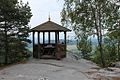
Refuge on the east view

View of the west view ( "weather vane view " )
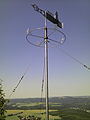
Weather vane from 1985
.jpg)
.jpg)
.jpg)
.jpg)
_2014.jpg)
Climbing rock
The Gohrisch is part of the Saxon Switzerland climbing area , but only has five climbing peaks on the south and west flanks, of which the “dwarf” (first ascent in 1905) and the “separated wall” are best known. The other climbing rocks are "Narrenkappe" , "Gohrischscheibe" and "Findling" .
view


The view from the Gohrisch is extremely comprehensive, the view sweeps practically over the whole of Saxon Switzerland and parts of Bohemian Switzerland . The view is enough
- to the south: across the extensive forests of the Saxon Switzerland on the left Elbe with the clearing islands of the villages Papstdorf and Cunnersdorf to the Zschirnsteinen and the Děčínský Sněžník (High Snow Mountain),
- in the north: over the village of Gohrisch to Lilienstein and the flatnesses on the right bank of the Elbe near Waltersdorf and Rathmannsdorf to the heights of the Lausitz Fault ,
- To the east: over the Papststein to the Schrammsteinen , the Großer Winterberg , the Tanečnice (Tanzplan) and the Unger , in the far east the mountains of the Lusatian Mountains can be seen, examples being Studenec (Kaltenberg), Jedlová (Tannenberg) and Called Klíč (Kleis),
- To the west: over the table mountains of the Saxon Switzerland on the left Elbe ( Pfaffenstein , Quirl , Königstein , Bärensteine , Rauenstein ) to the heights of the Eastern Ore Mountains .
literature
- Königstein area, Saxon Switzerland (= values of the German homeland . Volume 1). 1st edition. Akademie Verlag, Berlin 1957.
- Dieter Kutschke, Klaus Schneider: Commemorative signs and quarter angles in the soapstone tunnel at Gohrisch near Königstein. Bulletin No. 7 of the Saxon Switzerland AK in the Saxon Heritage Protection Association. Pirna 2008, pp. 18-23
- Peter Rölke: hiking and nature guide Saxon Switzerland. Volume 2 Front and South Saxon Switzerland. Berg- und Naturverlag Rölke, Dresden 2013, ISBN 978-3-934514-09-6
- Klaus Schneider: The Gohrischstein in the literature of the 18th and 19th centuries . in: Saxon Switzerland Working Group in the Saxon Heritage Protection Association, Bulletin 12, Pirna 2013, pp. 1–43
- Bernd Ullrich, Dieter Kutschke: Historical and mineralogical aspects of the mining experiment at Gohrisch ("soapstone tunnel") in the Elbe Sandstone Mountains (Saxony). in: Geologica Saxonica 52/53 (2007), pp. 69–90 ( digital copy ; PDF; 1.8 MB)
Web links
Individual evidence
- ↑ a b Michael Bellmann: The via ferrata guide . Via ferratas and stairs in Saxon Switzerland. 2nd Edition. Heimatbuchverlag Bellmann, 2013, ISBN 978-3-937537-42-9 , p. 131 ff .
- ↑ Ferdinand Thal: Guide to Saxon Switzerland. Verlag HH Grimm, Dresden 1846, p. 75
- ↑ Bernd Ullrich, Dieter Kutschke: Historical and mineralogical aspects of the mining experiment on Gohrisch ("soapstone tunnel") in the Elbe Sandstone Mountains (Saxony). in: Geologica Saxonica 52/53 (2007), pp. 69–90 ( digitized version ( memento of the original from December 27, 2013 in the Internet Archive ) Info: The archive link has been inserted automatically and has not yet been checked. Please check the original and archive link accordingly Instructions and then remove this note .; PDF; 1.8 MB)
- ↑ Bernd Ullrich, Dieter Kutschke: Historical and mineralogical aspects of the mining experiment on Gohrisch ("soapstone tunnel") in the Elbe Sandstone Mountains (Saxony). in: Geologica Saxonica 52/53 (2007), pp. 85ff.
- ↑ Dieter Kutschke, Klaus Schneider: Gedingezeichen and Quarterswinkel in the soapstone tunnel at Gohrisch near Königstein. Bulletin No. 7 of the Saxon Switzerland AK in the Saxon Heritage Protection Association. Pirna 2008, p. 22