
Pope stone
| Pope stone | ||
|---|---|---|
 |
||
| height | 451.2 m above sea level HN | |
| location | Saxony ( Germany ) | |
| Mountains | Elbe Sandstone Mountains | |
| Coordinates | 50 ° 54 '12 " N , 14 ° 7' 16" E | |
|
||
| Type | Table Mountain | |
| rock | Sandstone level e | |
| Age of the rock | Coniac | |

The Papststein (451 m) is a table mountain in Saxon Switzerland on the left bank of the Elbe in Saxony .
Location and surroundings
The Papststein is located about four kilometers southeast of Königstein and about three kilometers south of Bad Schandau in the middle of a plateau ( flatness ) , which is dominated by other, similar rocky mountains. The surrounding mountains are the Gohrisch , the Kleinhennersdorfer Stein and the Lasensteine . In terms of tourism, this microregion in Saxon Switzerland is often referred to as the area of stones . At the foot of the Papststein lies the small town of Papstdorf , which belongs to the Gohrisch community . On the summit there is a mountain inn and a fire watch tower that is not accessible to the public .
history
The papal stone was first mentioned in 1496 as the " Bogerßdorfer stone ". Other earlier forms of the name were " Babsdorffer Stein " (early 17th century) and " Pabstdorffer Stein " (1736), before the name form that is used today emerged at the beginning of the 19th century.
As early as 1780, the Papststein was opened up by a path ("Old Path"), which is no longer accessible today. Wilhelm Leberecht Götzinger recommended climbing the summit in 1812 and wrote: " But first the Papststein has to be climbed (...) Those who let themselves be led up to it will find an excellent view in the vicinity and some in the distance (...) ."
At the beginning of the 19th century, the area of the Papstein was under the control of the Royal Saxon Forest Administration, which in 1829 had parts of the summit plateau cut down to create a better view. In 1830 the Saxon prince (and later king) Friedrich August climbed the Pope's stone and thus laid the foundation for a greater tourist interest in the mountain with a great view. A travel guide noted in 1846: “In recent years, as it is extremely rewarding, more attention than in the past has been given to the splendid panoramic view between the Königstein and Lilienstein, to Pillnitz and Dresden, as well as to the rocky world beyond the Elbe so that the visit to this rock is more and more popular. "
The canyon on the east climb was made accessible in 1845. In 1858 a wooden pavilion was built on the summit, and in 1862 the mountain inn, which still exists today, followed. A rock inscription near the west view reminds of the forest survey carried out in 1863. In 1889 a small stone observation tower was built on the highest point of the mountain at the southern tip, which was demolished in 1936 due to its dilapidation. As a follow-up building, a new 9 meter high wooden tower was built in 1937, which was also used as a fire watch tower and existed until 1969. The wooden tower was followed by a prefabricated concrete fire watch tower, which is not open to the public. The cable car leading to the Papststein is also located near the tower.
On January 17, 1972, a 15 meter high, 12 meter wide and 8 meter deep wall with a rock mass of up to 4000 m³ fell down from the Papststein on the south side and tore a 30 meter wide aisle into the forest, which is still today is clearly visible.
In October 1996 the Bundeswehr carried out the exercise "Jäger 96" in the area of the Pope, which was accompanied by massive protests by residents, hikers and mountaineers and which, due to the protests, could not be carried out to the intended extent.
geology
Originally, the Papststein, together with the neighboring Gohrisch and Kleinhennersdorfer Stein, formed a coherent sandstone slab, which in the course of its development history eroded from the north into three residual massifs , which today form the stones mentioned.
The Papststein consists of sandstones of grades c, d and e, which are classified in the geological time scale in the grades Middle and Upper Turon or Coniac of the Chalk . In more recent publications these wall-forming sandstones are also referred to as Postelwitzer , Rathewalder and Schrammstein layers . The intermediate layer γ3, which is inserted between levels c and d, is exposed to very strong weathering; in the terrain it is usually recognizable as a terrace. Cavities formed in this intermediate layer were also the cause of the 1972 landslide.
Climbing rock
The Papststein belongs to the area of stones in the climbing area of Saxon Switzerland . However, it only has the three climbing peaks “ Große Hunskirche ” (first ascent 1880), “ Kleine Hunskirche ” (first ascent in 1893 by a rope team led by Oscar Schuster ) and “ Papst ”, which, however, offer mountaineers over 120 routes. A demanding level of difficulty up to IXc is achieved at the “ Great Hunskirche ” .
view
The view from the Papststein is quite extensive, the view sweeps over large parts of Saxon and Bohemian Switzerland . In addition to the Gohrisch and the Zschirnsteinen , the more distant peaks Děčínský Sněžník (High Snow Mountain) , Růžovský vrch (Rosenberg) , the Schrammsteine with Falkenstein and Great Winterberg , Tanečnice (dance plan) and Unger are in the field of vision . In the far east, the mountains of the Lusatian Mountains can be seen, examples being Studenec (Kaltenberg) , Jedlová (Tannenberg) and Klíč (Kleis) .
.jpg)
.jpg)
Paths to the summit
- A hiking trail marked with a red dot leads over the Gohrisch , which has its starting point in Königstein and leads over the Gohrisch and the Papststein towards the cribs . The path is part of the Malerweg , established in 2006 , the main hiking trail in Saxon Switzerland.
- A good starting point for visiting the mountain is also the parking lot for hikers on the connecting road Kurort Gohrisch – Papstdorf. About the above The summit can be reached on foot in about 20 minutes.
gallery

View from the Pfaffenstein to the Papststein

View from the Papststein to the Lilienstein

Climbing rocks " Große Hunskirche " and " Kleine Hunskirche "

Eastern ascent to the Papststein (part of the Malerweg)

Mountain station of the freight cable car with the Gohrisch in the background

The fire watch tower on the south view
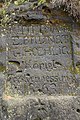
Inscription of the royal forest survey from 1863

Mountaineer on the " Pope "
.jpg)

.JPG)
.jpg)
.JPG)
.jpg)
.jpg)

Individual evidence
- ↑ Alfred Meiche: Historical-topographical description of the Pirna administration . Dresden 1927, p. 213
- ↑ Information on the Papststein (accessed December 29, 2013)
- ^ Wilhelm Leberecht Götzinger: Schandau and its surroundings or description of the so-called Saxon Switzerland . Dresden 1812 (Reprint Verlag der Kunst Dresden, Husum 2008, p. 304) ( digitized version of the original edition )
- ^ Andreas Martin: Focused Landscape. Lookout towers in Saxon Switzerland . in: Rolf Wilhelm Brednich, Annette Schneider, Ute Werner (eds.): Nature-Culture. Folklore perspectives on people and the environment . Waxmann, Münster / Munich / Berlin / New York 2001, pp. 177–188, here: p. 185
- ↑ Ferdinand Thal: The latest guide through Saxon Switzerland . Verlag HH Grimm, Dresden 1846, p. 75 ( digitized version )
- ↑ Peter Rölke (ed.): Hiking and nature guide Saxon Switzerland. Bd. 2 Front and southern Saxon Switzerland . Bergverlag Rölke, Dresden 2000, 182ff.
- ↑ War Games in Saxon Switzerland? No thanks! (Accessed December 28, 2013)
- ↑ Anniversaries of first ascents in Saxon Switzerland (accessed December 29, 2013)
- ↑ Felsinfo "Große Hunskirche" in the rock database of the DAV ( accessed October 19, 2016)
literature
- Königstein area, Saxon Switzerland (= values of the German homeland . Volume 1). 1st edition. Akademie Verlag, Berlin 1957.
- Andreas Martin: Focused Landscape. Lookout towers in Saxon Switzerland . in: Rolf Wilhelm Brednich, Annette Schneider, Ute Werner (eds.): Nature-Culture. Folklore perspectives on people and the environment . Waxmann, Münster / Munich / Berlin / New York 2001, pp. 177–188
- Alfred Meiche : Historical-topographical description of the Pirna administration . Dresden 1927
- Peter Rölke (ed.): Hiking and nature guide Saxon Switzerland. Volume 2 Front and South Saxon Switzerland . Berg- und Naturverlag Rölke, Dresden 2000