
Kleinhennersdorfer Stein
| Kleinhennersdorfer Stein | ||
|---|---|---|
.jpg) View from the west |
||
| height | 392.1 m above sea level HN | |
| location | Saxony ( Germany ) | |
| Mountains | Elbe Sandstone Mountains | |
| Coordinates | 50 ° 54 '30 " N , 14 ° 7' 47" E | |
|
||
| Type | Table Mountain | |
| rock | Sandstone level d | |
| Age of the rock | Upper Turon | |

The Kleinhennersdorfer Stein (392 m) is a table mountain in Saxon Switzerland in Saxony on the left bank of the Elbe . It has been under protection as an extensive natural monument since 1979 .
Location and surroundings
The Kleinhennersdorfer Stein is located about four kilometers southeast of Königstein and about two kilometers south of Bad Schandau in the middle of a plateau ( flatness ) that is dominated by other similar rocky mountains. The surrounding mountains are the Gohrisch , the Papststein and the Lasensteine . In terms of tourism, this microregion in Saxon Switzerland is often referred to as the area of stones . At the foot of the Kleinhennersdorfer Stein lie the small towns of Kleinhennersdorf and Papstdorf , which belong to the Gohrisch community . On the south side - close to the saddle to the neighboring Papststein - there are three well-known caves in Saxon Switzerland, the light cave , the ice cave and the Hampel cave .
history
In 1461 the Kleinhennersdorfer Stein was first mentioned in a document as the Heynersdorfer Stein . In the 16th century, the Kirchsteig running from Kleinhennersdorf to Königstein led along the foot of the north fall .
Sand extraction
On the south side of the rock massif is the now 20 meter long and 15 meter wide light cave, a layer joint cave. The cave got its current size when around 1870 the Königstein resident Friedrich Herrmann Hempel began the commercial mining of sandstone, which was crushed and ground and sold as scouring sand to inns and soap factories. The two collapse caves on the south side were considerably enlarged by the mining, so that extraction there was later officially prohibited. On December 17, 1918, Hempel lost his life when a rock collapsed in the foreground.
geology
The sandstones of the Kleinhennersdorfer Stone belong to grades c and d, which are classified in the Upper Turon of the Chalk on the geological time scale . In more recent publications these are also referred to as Schrammstein layers . Weathering into honeycombs and hourglasses is typical of this sandstone.
C between the sandstone steps and d is located at a height of about 350 m (in the north of Kleinhennersdorfer stone) or 365 m (in the south of Kleinhennersdorfer Stone) a labeled γ3 intermediate layer of clay - silt sediments, which is water-thawing and thereby easily prone to weathering and cave formation. The caves on the Kleinhennersdorfer Stein (" Lichterhöhle ", " Eishöhle ", " Hampelhöhle ") are formed within this horizon .
view
Due to the low altitude, the heavy forest and the already advanced erosion and fragmentation of the summit plateau, the Kleinhennersdorfer Stein does not offer a comprehensive view in contrast to the neighboring stones.
However, from the flatness at the southeastern foot of the mountain, a further view in west direction of Falkenstein, Hohe Liebe, Schrammsteine , Großer Winterberg, Kohlbornstein and Hinterer Laasenstein is possible.
Paths to the summit
The starting point for a hike is usually the village of Kleinhennersdorf. From here the marked “ Malerweg ”, the main hiking trail in Saxon Switzerland, leads directly past the southeastern foot of the Kleinhennersdorfer Stein. From the Malerweg, two unmarked ascents branch off to the summit. From the west there are also two unmarked accesses to the mountain through two rocky gorges.
The only marked access to the Kleinhennersdorfer Stein is the “ Forststeig ” trekking route set up in 2018 . The forest path crosses the Kleinhennersdorfer Stein from north to south, access from the north is through the canyon "Hölle", access from the south is past the caves.

southeast entrance
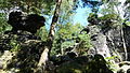
Rocks on the summit plateau

View to the Königstein

Cave of Lights

Jumping cave


Individual evidence
- ↑ State Environmental Office Radebeul (Ed.): Extensive natural monuments in the district of Saxon Switzerland. As of December 31, 1998. Radebeul 1999, p. 37
literature
- Königstein area, Saxon Switzerland (= values of the German homeland . Volume 1). 1st edition. Akademie Verlag, Berlin 1957.
- Alfred Meiche : Historical-topographical description of the Pirna administration. Dresden 1927
- Roland H. Winkelhöfer: Through caves in Saxon Switzerland. Cave guide and cadastral documentation. (1998/2010) Verlag DER HÖHLENFORSCHER, Dresden ISBN 3-00-002609-6