Hohnstein (Saxon Switzerland)
| coat of arms | Germany map | |
|---|---|---|
|
Coordinates: 50 ° 59 ′ N , 14 ° 7 ′ E |
|
| Basic data | ||
| State : | Saxony | |
| County : | Saxon Switzerland-Eastern Ore Mountains | |
| Height : | 330 m above sea level NHN | |
| Area : | 64.64 km 2 | |
| Residents: | 3282 (Dec. 31, 2019) | |
| Population density : | 51 inhabitants per km 2 | |
| Postal code : | 01848 | |
| Area code : | 035975 | |
| License plate : | PIR, DW, FTL, SEB | |
| Community key : | 14 6 28 190 | |
| Address of the municipal administration: |
Rathausstrasse 10 01848 Hohnstein |
|
| Website : | ||
| Mayor : | Daniel Brade (UWV) | |
| Location of the municipality of Hohnstein in the Saxon Switzerland-Eastern Ore Mountains district | ||

Hohnstein is a country town in the Saxon Switzerland-Eastern Ore Mountains district in Saxony . The city lies on the right Elbe on a plateau above the Polenz valley .
geography
Geographical location
Hohnstein and its affiliated districts are located on or north of the Lusatian Thrust, which forms the border between the actual Elbe Sandstone Mountains and the West Lusatian mountain and hill country made up of granite , and thus on the edge of the Saxon Switzerland National Park (with the exception of Waitzdorf).
City structure
The city has around 3,500 inhabitants and since 1994, in addition to Hohnstein itself, the districts of Cunnersdorf , Ehrenberg , Goßdorf with Kohlmühle and Waitzdorf , Lohsdorf , Rathewalde with Hohburkersdorf and Zeschnig , and Ulbersdorf , which have their own coats of arms.
Cunnersdorf
Cunnersdorf, three kilometers northeast of Hohnstein at an altitude of 345 m, is an old German foundation from the times of the eastern settlement in the 12th and 13th centuries. After the complete destruction of the village, first mentioned in documents in 1430, during the Thirty Years' War , a forest hoof village was created along the village stream .
Ehrenberg
Ehrenberg, also a Waldhufendorf in the southeastern connection to Cunnersdorf, extends for almost three kilometers along the Ehrenberger Bach to almost its confluence with the Schwarzbach. Like its northern neighbor, the Franconian foundation dates from the 12th / 13th centuries. Century.
Goßdorf
Goßdorf is located five kilometers southeast of Hohnstein on the way to Bad Schandau and is again divided into three parts: Goßdorf, Kohlmühle with a stop on the Bautzen – Bad Schandau railway (Sebnitztalbahn) and Waitzdorf.
Lohsdorf
Lohsdorf lies in a side of the Schwarzbach valley. The corridor of the row village stretches in long strips (forest hooves) from the farmsteads behind the village stream to the southwest 1.5 km. The Lohsdorf district of Sorge forms a row of houses that lean against the steep slope on the left bank. The Schwarzbach rises at 430 m above sea level on the western slope of the Unger. In the upper reaches north of Lohsdorf, the Schwarzbachtal is gently sunk into the plateau and forms a meadow valley. A hiking trail stretches from Ehrenberg via Lohsdorf down into the valley. From its highest point, the Gickelsberg (414 m), you can see Saxon Switzerland.
Rathewalde
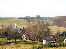
The row village Rathewalde in the valley basin of the Grünbach is located at the upper exit of the Amselgrund around two kilometers west of Hohnstein. Erbgericht, Lindenhof and Hutenhof still bear witness to the rich old farming families with their size. Rathewalde has an outdoor pool, an adventure pool since 1995, and is the starting point and intermediate point for a variety of hiking trails. The Rathewalder footpath leads to the bastion . The route through the Amselgrund ushered in the era of tourism after the opening of the steamship line on the Elbe . Other destinations are the Schwedenlöcher , the stone table, the Rathewalder Höhe with its monument and its poplar trees and the Hohburkersdorfer panorama. The district of Rathewald is part of the flat, undulating Rathewalder edge flatness, on which Elbe river gravel from the Early Elster Cold Age and Pleistocene gravel moraine remnants can be found. The largest part is covered by the Weichselian loess loam .
Ulbersdorf
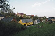
The forest hoof village Ulbersdorf with its 500 inhabitants at 260 m altitude is about ten kilometers east of Hohnstein, only five kilometers before Sebnitz in a right Sebnitz side valley . Ulbersdorf was first mentioned in 1432. Behind the 17th century village church, ramparts and moats at the so-called Schneckenberg testify to an early German moated castle . The castle of a former manor from the 16th century with alterations from the 18th and 19th centuries is still preserved . A number of half-timbered and half-timbered houses can also be seen. The Sebnitztalbahn stop is on the southern outskirts. On the outskirts is the Große Hutberg with a height of 336 m .
Waitzdorf
Waitzdorf is located on the Waitzdorf flat edge at 330 m above the Tiefen Grund. The remote Waldhufendorf has only a few residents. The highest point is the two-peaked granite mountain (anatexite) of the Waitzdorfer Höhe with the 423.5 m high, forest-free north-west summit and the predominantly wooded south-west summit of 414 m. The Galloway cattle that graze on the local meadows are an attraction .
history
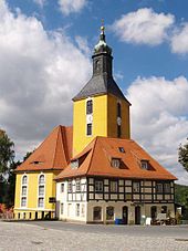
The place was first mentioned in 1333 in connection with the much earlier built Hohnstein Castle . Hohnstein probably received town charter in 1444. Hohnstein was hit by a devastating city fire in 1724. About half of the houses burned down. The rebuilt town church was built in 1724-28 based on plans by George Bähr .
In order to improve the economic and tourist development of Hohnstein, the Schwarzbachbahn , a narrow-gauge railway from Kohlmühle to Hohnstein, was built in 1897 . In 1951 operations were stopped.
At the beginning of the 20th century tourism gained in importance, but the first visitors to Saxon Switzerland had visited the place since 1850 .
The town's castle complex was used in 1933 as one of the early concentration camps ( Hohnstein concentration camp ) in Germany during the National Socialist era. Around 5,600 prisoners, including 109 women and 400 young people, were detained there. They were used for hard labor in the Heeselicht quarry . Several communists and social democrats died here as a result of the torture by SA members , and some took their own lives. Since the beginning of the Second World War , the castle served as a prison camp (Oflag) for 800 Polish and then French officers, later as Stalag IV / 4 for Yugoslav and Soviet prisoners of war .
During the GDR era, a children's holiday camp was operated in the district of Rathewalde .
Surname
The spelling of the place name has changed several times over the years. The following spellings have been handed down from historical sources. 1317: Hoinstein, 1335: Hohenstein, 1353: Hohenstayn, 1388: czu dem Honstein, 1391: Hoenstain, 1413: Hostein, 1430: Hoynstein, 1443: Hoenstein an der Politz, 1445: the statichen czum Honsteyne, in the stadichin under the Honstein, 1510: Huntzstein and 1791: Hohnstein.
Incorporations
- July 1, 1965: The municipalities of Zeschnig and Hohburkersdorf merge to form Zeschnig-Hohburkersdorf.
- April 1, 1972: Zeschnig-Hohburkersdorf is incorporated into Rathewalde.
- June 14, 1973: Waitzdorf is incorporated into the town of Hohnstein.
- April 1, 1974: Cunnersdorf is incorporated into Ehrenberg.
- January 1, 1994: The communities Ehrenberg, Goßdorf, Lohsdorf, Rathewalde and Ulbersdorf are incorporated into the city of Hohnstein.
coat of arms
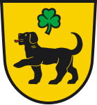
Blazon : Under a three-leaved green shamrock in gold (yellow) a red-tongued black dog striding to the right.
Meaning : The meaning of the dog is not clear, it may come from Hund-stein. The dog appears on the city's oldest known coat of arms from the 16th century. The shamrock can already be seen there, the meaning of which is also unclear. Later versions again only showed the coat of arms with a dog.
politics
City council
Since the municipal council election on May 26, 2019 , the 14 seats of the city council have been distributed among the individual groups as follows:
- Independent Electoral Association (UWV): 6 seats
- CDU : 3 seats
- AfD : 1 seat
- Bündnis90 / Die Grünen : 1 seat
Twin cities
- Meersburg on Lake Constance in Baden-Württemberg , Germany, since 1991
- Louveciennes in Île-de-France , France
- Miltach in Bavaria , Germany, since 1992
- Budyně nad Ohří an der Eger , Czech Republic, since 2008
Puppetry / film location
The name Hohnstein is associated with the puppet theater Die Hohnsteiner , which Max Jacob founded in the early 1920s as part of the Wandervogel movement . Later three more Hohnsteiner puppet theaters were formed (directors: Friedrich Arndt , Erich Kürschner and Harald Schwarz ), whose headquarters were no longer in Hohnstein itself. Above all, Max Jacob and Friedrich Arndt made Die Hohnsteiner famous worldwide through film, television, sound carriers, literature and hand puppets produced in series . There is no longer a Hohnstein stage. Numerous, imitative travel theaters , however, boast the name Hohnsteiner .
The Hohnstein hand puppet workshop is still located in Hohnstein. After the death of Theo Eggink , the creator of numerous hand puppets and the puppet theater ensemble, first Gerhard Berger, then his son Wolfgang, took over the carving workshop that sends the Hohnstein puppets all over the world.
Hohnstein was often a film location. One of the first television series of the German television station Rote Bergsteiger was filmed here in 1967, as well as various scenes for the Police Call 110 episode " The Lifeguard " in 1981 .
Culture and sights
Memorials
- Monument by Wilhelm Landgraf at the entrance to today's youth hostel Burg Hohnstein from 1961 for the victims of fascism , as well as several memorial plaques
- Memorial plaque in Polenztal 1 at the mill to commemorate the suffering of the prisoners
tourism
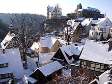
Hohnstein is located directly on the Saxon Switzerland National Park . Hohnstein Castle in particular , which is also the reason for Hohnstein's founding, is an attraction and, as a house for friends of nature, the starting point for hiking and climbing tours in the national park. Three kilometers south of Hohnstein is the fire view , which is 177 meters above the Polenz valley . The Märzenbecherwiesen in the Polenztal are an attraction in spring.
The puppet stage Hohnsteiner Kasper is named after the place and the castle Hohnstein, which had its first performances in the castle in 1928 and later resided in a puppet house provided by the city.
The Deutschlandring motorsport racetrack was built near the city in the 1930s. After the war, the races did not resume. The maintenance of the racetrack was too expensive. It was only after 1990 that the road was restored to good condition. Since there were several deaths in illegal races, the route was dismantled.
Personalities
sons and daughters of the town
- Johann Christoph Schmidt (1664–1728), composer
- Christoph Gottlieb Schröter (1699–1782), composer
- Christoph Schaffrath (1709–1763) composer, harpsichordist, music theorist
- Karl Gustav Zumpe (1819–1900), lawyer and politician, MdL
- Elisabeth Grünwaldt (1871–1961), costume designer for the Hohnstein puppet theater and silhouette artist
- Karl Anton Talazko (1897–1945), Protestant pastor, opponent of the war and victim of the Nazi dictatorship
- Theo Eggink (1901–1965), the Hohnsteiner “Kasperschnitzer” and silhouette artist
- Hellmuth Barthel (* 1927), geographer
- Bernd Arnold (* 1947), climber and mountaineer
- Matthias Gäbler (1949–2009), climber and mountaineer
Persons connected with Hohnstein
- Johann Michael Weiß (1648–1726), theologian. He worked as a pastor in Hohnstein and is considered to be the author of a chronicle of the Office of Hohnstein published in 1729 .
- Christian Röhrensee (1641–1706) ethicist and political scientist
- Wilhelm Leberecht Götzinger (1758–1818) pastor and “discoverer” of Saxon Switzerland
- Willy Rotzsch (Rathewalde, 1883–1912), teacher and dialect poet
- Max Jacob (1888–1967), founder of the Hohnstein puppet shows
- Friedel Kostors (1897–1986), costume designer and designer of textile figures for the Hohnstein puppet theater
Honorary citizen
- Otto von Bismarck , politician and Reich Chancellor (since 1895)
- Dr. Walter Noack, doctor (since 1984)
- Albert Vester, former Mayor (since 1984)
- Bernd Arnold , climber and mountaineer (since 2008)
- Dietrich Graf, former head of the forestry office and district nature conservation officer (since 2008)
- Gerhard Berger, puppet carver (since 2013)
- Eberhard Barthel (1936 - 2018)
literature
- Königstein area, Saxon Switzerland (= values of the German homeland . Volume 1). 1st edition. Akademie Verlag, Berlin 1957.
- Hellmuth Barthel : Hohnstein - Polenztal: in the landscape protection area Saxon Switzerland, Stolpen , Tourist-Wanderheft Volume 2, Tourist-Verlag, Berlin / Leipzig 1987
- Wilhelm Leberecht Götzinger : History and description of the Chursächsischen Amt Hohnstein with Lohmen, in particular the city of Sebniz , which belongs to this office , Freiberg 1786 (Reprint Sebnitz 1987) ( digitized version )
- Edgar Hahnewald : Hohnstein . in: Communications of the Landesverein Sächsischer Heimatschutz Volume XX, Issue 1–2 / 1931, Dresden 1931, pp. 70–76
- Hans Hofmann: Castle and City of Hohnstein , Dresden 1954
- Hermann Knothe : The Berka from the Duba on Hohnstein, Wildenstein, Tollenstein and their relations to the Meissnischen princes , in: New archive for Saxon history and antiquity . Volume 2, Issue 3, Dresden 1881, pp. 194–236 ( digitized version )
- Matthias Schober: Hohnstein and its surroundings in old views , European Library Publishing House, Zaltbommel 2002, ISBN 90-288-6694-9
- City of Hohnstein (ed.): Hohnstein and the surrounding area in the Saxon Switzerland national park region. Hohnstein 1995
Web links
- Hohnstein in the Digital Historical Directory of Saxony
Individual evidence
- ↑ Population of the Free State of Saxony by municipalities on December 31, 2019 ( help on this ).
- ↑ Cf. Hohnstein in the Digital Historical Directory of Saxony
- ↑ Results of the 2019 municipal council elections
- ↑ Documentation of the GDR-FS / DFF , German Broadcasting Archive (DRA) Potsdam-Babelsberg


