Hohburkersdorf
|
Hohburkersdorf
City of Hohnstein
Coordinates: 50 ° 59 ′ 50 ″ N , 14 ° 4 ′ 40 ″ E
|
|
|---|---|
| Height : | 360 m above sea level NN |
| Area : | 2.55 km² |
| Residents : | 92 (May 9, 2011) |
| Population density : | 36 inhabitants / km² |
| Incorporation : | July 1, 1965 |
| Incorporated into: | Zeschnig-Hohburkersdorf |
| Postal code : | 01848 |
| Area code : | 035975 |
|
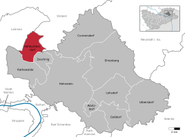
Location of Hohburkersdorf in Hohnstein
|
|
Hohburkersdorf is a district of Hohnstein in the Saxon Switzerland-Eastern Ore Mountains district . In addition to the neighboring Zeschnig , it belongs to the village of Rathewalde .
geography
Hohburkersdorf is located east of the Saxon capital Dresden in the north of Saxon Switzerland . It is located in the northeast of the Saxon Switzerland-Eastern Ore Mountains district. The Waldhufendorf is located on the Lusatian Fault , which forms the border between the Lusatian granite massif in the north and the Elbe Sandstone Mountains in the south. The local situation Hohburkersdorf is at the beginning of a steep side valley towards the Goldflüsschen, a right tributary of the Polenz . The highest point is the Hohburkersdorfer Rundblick south of the village at 398 meters.
Edge areas of the district , especially the slopes in the extreme east and west, are wooded. A large part of the 255 hectare corridor is used for agricultural purposes. The district of Rathewalde borders in the south and Zeschnig in the east. The northeastern neighbor is Heeselicht , a district of Stolpen , to the northwest is Stürza , a district of Dürrröhrsdorf-Dittersbach . The closest town to the west is Lohmen .
The most important street on Hohburkersdorf Flur is Kaiserstraße, which leads as state road 165 from the direction of Stürza to the Bad Schandau district of Waltersdorf . Projected from 1933 as part of the former Deutschlandring race track , it cuts through the location roughly in the middle and bridges the Brückenstraße, which opens up the Hohburkersdorf town center. In the north of the Hohburkersdorfer Flur it flows into the state road 161, which connects Stürza with Heeselicht. Hohburkersdorf is connected to the regional bus network of Saxon Switzerland and Eastern Ore Mountains (RVSOE) .
history
In the first half of the 15th century, Hohburkersdorf belonged to the Margraviate of Meissen as a fief . The fief later fell into the hands of Caspar von Miltitz (noble family) . The residents of Hohburkersdorf were parish in Stürza .
The Hohburkersdorfer Rundblick, which is about 500 m south of the town center, has been of strategic importance since 1813 . Then a tree , the Napoleon linden, was planted there.
In 1835 the Saxon issued government the people Education Act with an eight-year compulsory education and obliged the communities , the maintenance of schools . For the small village of Hohburkersdorf, having its own school meant huge financial expenditures. The parish council had a school building built for both places with the neighboring parish of Zeschnig . It was completed in 1855 .
The Deutsche Fotothek has a photo of the Napoleon linden tree from the Hohburkersdorfer Rundblick from 1910 . This photograph is available online. It shows a fence and a bench, but no memorial yet . This was erected in 1923 and contains the name of the soldier from Hohburkersdorf who fell in France on a plaque.
In the year 1930 appeared from the address book publisher Julius Mißbach in Neustadt in Sachsen a resident book ( address book ) for Neustadt in Sachsen, Stolpen and Hohnstein (Saxon Switzerland) . This also lists the residents of Hohburkersdorf. The residents marked with the square are the house owners and the number of the house is behind the name .
literature
- Königstein area, Saxon Switzerland (= values of the German homeland . Volume 1). 1st edition. Akademie Verlag, Berlin 1957, p. 36 f.
Web links
- Hohburkersdorf in the Digital Historical Directory of Saxony
- Hohburkersdorf and Zeschnig on the website of the city of Hohnstein
Individual evidence
- ^ Population, households, families as well as buildings and apartments on May 9, 2011 according to parts of the municipality. (PDF; 770 KB) In: Kleinräumiges Gemeindeblatt Census 2011. State Statistical Office Saxony , accessed on October 3, 2016 .

