
Budyně nad Ohří
| Budyně nad Ohří | |||||
|---|---|---|---|---|---|
|
|||||
| Basic data | |||||
| State : |
|
||||
| Region : | Ústecký kraj | ||||
| District : | Litoměřice | ||||
| Area : | 3,358.0837 ha | ||||
| Geographic location : | 50 ° 24 ' N , 14 ° 8' E | ||||
| Height: | 161 m nm | ||||
| Residents : | 2,175 (Jan 1, 2019) | ||||
| Postal code : | 411 18 | ||||
| License plate : | U | ||||
| traffic | |||||
| Railway connection: | Libochovice – Vraňany | ||||
| structure | |||||
| Status: | city | ||||
| Districts: | 7th | ||||
| administration | |||||
| Mayor : | Petr Medáček (as of 2007) | ||||
| Address: | Mírové náměstí 65 411 18 Budyně nad Ohří |
||||
| Municipality number: | 564656 | ||||
| Website : | www.budyne.cz | ||||


Budyně nad Ohří (German Budin an der Eger ) is a city in the Czech Republic . It is located 10 km west of Roudnice nad Labem at 161 m above sea level. M. on the right bank of the Eger and belongs to the Okres Litoměřice .
history
Archaeological excavations show that the Egerufer near Budyně dates back to 3000 BC. Was settled. According to old chronicles, the present place existed already in the 9th century and received city rights in 1173.
The connecting road between Raudnitz and Libochowitz led here over the Eger and the path was protected by Budyně Castle .
Budyně remained a peaceful country town in the course of its long history and lost its town charter in 1954. Since 1996 Budyně has been a city again.
The town lies on the secondary railway line Libochovice - Mšené-lázně and is surrounded by the alluvial forest on the Eger, which has been declared a nature reserve. In addition to traditional horticulture in the fertile “Garden of Bohemia”, there are also mechanical engineering and electrical industries.
Dálnice 8 bypasses the city in the north and east in a distance of 5–6 km and can be reached via exit 35 Doksany .
Community structure
The city consists of the districts Břežany nad Ohří ( Breschan ad Eger ), Budyně nad Ohří ( Budin an der Eger ), Kostelec nad Ohří ( Kosteletz ad Eger ), Nížebohy ( Nischebohy ), Písty ( Pist ), Roudníček ( Raudnitschek ) ( Wirbka ), which at the same time also form cadastral districts. Basic settlement units are Břežany nad Ohří, Břežany-u zastávky, Budyně nad Ohří, Hradčany, Kostelec nad Ohří, Nížebohy, Písty, Roudníček and Vrbka.
Attractions
- Budyně Castle , a historic moated castle, inside the walls of which an alchemist's workshop was recreated
- Wenceslas Church
- Church of the Virgin Mary
- Maria Schnee church
- Cross of the apostles Cyril and Method
- Virgin Mary sculpture
- City fountain
- Synagogue (cultural monument)
- Jewish cemetery with Tahara house
Town twinning
- Hohnstein (Saxon Switzerland) , Germany
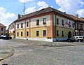
photos
The town hall

The house in Mírové square


Web links
- http://www.budyne.cz/ (Czech)
Individual evidence
- ↑ http://www.uir.cz/obec/564656/Budyne-nad-Ohri
- ↑ Český statistický úřad - The population of the Czech municipalities as of January 1, 2019 (PDF; 7.4 MiB)
- ↑ http://www.uir.cz/casti-obce-obec/564656/Obec-Budyne-nad-Ohri
- ↑ http://www.uir.cz/katastralni-uzemi-obec/564656/Obec-Budyne-nad-Ohri
- ↑ http://www.uir.cz/zsj-obec/564656/Obec-Budyne-nad-Ohri