Štětí
| Štětí | ||||
|---|---|---|---|---|
|
||||
| Basic data | ||||
| State : |
|
|||
| Historical part of the country : | Bohemia | |||
| Region : | Ústecký kraj | |||
| District : | Litoměřice | |||
| Area : | 5387.1912 ha | |||
| Geographic location : | 50 ° 27 ' N , 14 ° 22' E | |||
| Height: | 155 m nm | |||
| Residents : | 8,685 (Jan 1, 2019) | |||
| Postal code : | 411 08 | |||
| License plate : | U | |||
| traffic | ||||
| Railway connection: | Kolín – Děčín , Praha – Děčín | |||
| structure | ||||
| Status: | city | |||
| Districts: | 10 | |||
| administration | ||||
| Mayor : | Tomáš Ryšánek (as of 2014) | |||
| Address: | Mírové nám. 163 411 08 Štětí |
|||
| Municipality number: | 565709 | |||
| Website : | www.steti.cz | |||
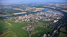
Štětí (German Wegstädtl ) is a town in the Leitmeritz district in the Czech Republic .
Geographical location
The city is located in northern Bohemia on the right bank of the Elbe , ten kilometers northeast of Roudnice nad Labem ( Raudnitz ), 16 kilometers west of Mělník and about 50 kilometers north of Prague
history
The settlement on a plain on the Elbe goes back to a Meierhof of the Melnik rule , which already existed in 1312. The site has received numerous privileges, such as the high and low jurisdiction, but was under as free Street of Leibgedingeherrschaft Melnik. In 1561 the local handicrafts united in guilds . The oldest city books date from 1593 and 1627.
The city's location below a plateau 40 to 50 meters higher favored fruit and wine growing. The residents were predominantly German-speaking, the Elbe formed the language border.
During the Thirty Years' War , on November 11, 1620, troops of the Ligated invaded the city, murdering and looting and killing numerous residents. The Swedes invaded several times between 1640 and 1648 .
There were billeting and looting during the Seven Years' War ; Several ship bridges were built from Wegstädtl over the Elbe. After the Prussian invasion of Bohemia at the time of the plum rumble, several skirmishes between the Prussian and Austrian troops occurred in the vicinity of the city in 1778 .
In the past, Wegstädtl was hit several times by natural hazards. In 1716, 1788 and 1851 city fires broke out. Then there was the cholera epidemic of 1803. The Elbe floods in 1845 and 1784 each flooded over 70 houses, as did the church. The city suffered similar damage from the Elbe floods in 2002 .
The traffic connection was via district roads to Dauba , Gastorf and Liboch , but above all via shipping on the river. Businesses settled along the former Austrian Northwest Railway ( Vienna - Tetschen ), which runs north-east of the city, including the Winterfeld and Heller sugar factory founded in 1870 , from which a siding to the Northwest Railway Station was set up, and the Leopold Jelinek glove leather factory .
For the Prague - Bodenbach state railway on the left bank of the Elbe, a stop was set up in the opposite village of Hniewitz with a subsequent ferry connection to Wegstädtl. As part of the Elbe-Moldau regulation, a barrage was built in the Elbe below the city . In 1906 a model vineyard of the Viticulture Association for Bohemia was established . The pontoon bridge to Hniewitz, built as a temporary measure during the Elbe regulation in 1908 , remained in operation until 1973 and was replaced by a concrete bridge. The ship mill has also been out of service since the river was regulated .
After the First World War , Wegstädtl was added to the newly created Czechoslovakia in 1919 . Due to the Munich Agreement , Wegstädtl belonged from 1938 to 1945 to the district of Dauba , district of Aussig , in the Reichsgau Sudetenland of the German Empire . During the Second World War, the construction of a large tank farm of the Economic Research Association began near Hniewitz , which served war economic purposes and had a capacity of 200,000 m³. After the end of the war, the tank farm was blown up.
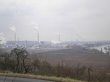
Due to the Beneš decrees , the German population was expropriated and expelled in 1945. In 1949, the largest paper mill in Central Europe, SEPAP, was built in Štětí and new residential areas were built. Sepap initially belonged to the Swedish paper group AssiDomän in the 1990s, was sold to the Austrian company Frantschach Pulp & Paper, as in 2000 and is now known as Mondi Štětí as The core town of Štětí has 7880 inhabitants.
Demographics
Until 1945 Wegstädtl was mostly populated by German Bohemia , which were expelled.
| year | Residents | Remarks |
|---|---|---|
| 1830 | 1042 | in 200 houses |
| 1900 | 1731 | German residents |
| 1930 | 1950 | |
| 1939 | 1681 |
| year | 1970 | 1980 | 1991 | 2001 | 2003 |
|---|---|---|---|---|---|
| Residents | 7016 | 9054 | 8571 | 9197 | 9165 |
City structure
The city Štětí consists of the districts Brocno (Brotzen) , Čakovice (Tschakowitz) , Chcebuz (zebu) , Hněvice (Hniewitz) , Počeplice (Potscheplitz) , Radouň (Radaun) , Štětí ( Wegstädtl ) Stračí (Stratschen) , Újezd (Aujezd ) and Veselí (Happy Village) . Basic development units are Brocno, obvod Čakovice, Chcebuz, Družstevní, Hněvice, K Hošteckému vrchu, Na Pelunci, Ostrovní, Papírenská, Počeplice, Průmyslový, Radouň, Sportovní areál Stare Štětí ( Alt Wegstädtl ) Stračenská, Stračí školní, Štětí II, Štětí -střed, U nádraží, Újezd, Veselí and Za okruhem.
The municipality is divided into the cadastral districts of Brocno, Čakovice u Radouně, Chcebuz, Hněvice, Počeplice, Radouň u Štětí, Štětí I, Štětí II, Stračí and Újezd u Chcebuze.
Attractions
Wegstädtl has a regular street scene, the center of which is formed by two squares, the large and the small ring.
The town church of St. Simon and Judah goes back to a previous building from 1300, which collapsed during the flood of 1784 . The church, built in 1785, has altar paintings by the painter Josef Kramolín . The elaborately carved stalls were taken over from the Church of St. Francis in Prague. From the old church there are two bells from 1530 and 1626, both of which have Czech inscriptions.
Personalities
- Johann Andreas Kayser von Kaysern (1716–1776), Bishop of Königgrätz
- Franz Reichelt (1878–1912), tailor in Vienna and Paris, famous parachutist
Web links
Individual evidence
- ↑ http://www.uir.cz/obec/565709/Steti
- ↑ Český statistický úřad - The population of the Czech municipalities as of January 1, 2019 (PDF; 7.4 MiB)
- ↑ Mondi Steti as ( Memento of November 27, 2012 in the Internet Archive )
- ↑ Yearbooks of the Bohemian Museum of Natural and Regional Studies, History, Art and Literature . Volume 2, Prague 1831, p. 196, paragraph 32.
- ↑ Johann Gottfried Sommer : The Kingdom of Bohemia . Volume 2: Bunzlauer Kreis , Prague 1834, p. 124.
- ^ Meyer's Large Conversational Lexicon . 6th edition, Volume 29, Leipzig and Vienna 1906, p. 459 .
- ^ A b Michael Rademacher: German administrative history from the unification of the empire in 1871 to the reunification in 1990. Dauba district. (Online material for the dissertation, Osnabrück 2006).
- ↑ http://www.uir.cz/casti-obce-obec/565709/Obec-Steti
- ↑ http://www.uir.cz/zsj-obec/565709/Obec-Steti
- ↑ http://www.uir.cz/katastralni-uzemi-obec/565709/Obec-Steti


