
Úštěk
| Úštěk | |||||
|---|---|---|---|---|---|
|
|||||
| Basic data | |||||
| State : |
|
||||
| Region : | Ústecký kraj | ||||
| District : | Litoměřice | ||||
| Area : | 7,495.0814 ha | ||||
| Geographic location : | 50 ° 35 ' N , 14 ° 21' E | ||||
| Height: | 242 m nm | ||||
| Residents : | 2,901 (Jan 1, 2019) | ||||
| Postal code : | 411 08-411 45 | ||||
| License plate : | U | ||||
| traffic | |||||
| Railway connection: | Řetenice – Lovosice – Česká Lípa – Liberec | ||||
| structure | |||||
| Status: | city | ||||
| Districts: | 24 | ||||
| administration | |||||
| Mayor : | Pavel Kundrát (as of 2014) | ||||
| Address: | Mírové náměstí 83 411 45 Úštěk |
||||
| Municipality number: | 565814 | ||||
| Website : | www.mesto-ustek.cz | ||||


Úštěk (German Auscha ) is a city in Ústecký kraj in the Czech Republic .
Geographical location
The city is located in northern Bohemia at the scenic transition between the Bohemian Central Mountains and Daubaer Schweiz . It was built on an elongated sandstone rock that slides along the Černý potok (Haberbach) from west to east in the area where it flows into the Úštěcký potok ( Munkerbach ).
history


The place was founded in the middle of the 11th century and elevated to a city in 1361. The original lords of Michalovice pledged the city to Berka von Dubá in 1387 . The city passed through numerous ecclesiastical and secular hands. Auscha is a center of hop growing and was a center of the Bohemian hop trade. In 1885 a hop hall was built and there were several large hop factories. The red hops produced were traded on the Auscha hop markets. The Arial Road ran straight through the city from Leitmeritz to Bohemian Leipa .
According to the Munich Agreement , the city belonged from 1938 to 1945 to the district of Leitmeritz , administrative district of Aussig , in the Reichsgau Sudetenland of the German Empire .
In the 1960s, the Chmelař recreational center was established north of the city. The creation of the artificial pond cleared and flooded the village of Zelená Ves ( Gründorf ). In the northwest lies the massif of the Geltschberg (Sedlo).
Today a total of around 2,800 people live in the 22 districts. The most important sources of income are traditionally agriculture, metal processing and furniture manufacturing. The share of textile production is constantly falling, with increases being recorded in the service sector. Unemployment is relatively high.
The city has served as a backdrop for feature films several times.
Demographics
| year | Residents | Remarks |
|---|---|---|
| 1830 | 1496 | in 265 houses, including 60 Jews |
| 1900 | 2642 | German residents |
| 1930 | 2244 | |
| 1939 | 2078 |
| year | 1970 | 1980 | 1991 | 2001 | 2003 |
|---|---|---|---|---|---|
| Residents | 3 187 | 2,981 | 2 703 | 2,662 | 2,664 |
Community structure
The city of Úštěk consists of 24 districts:
- Bílý Kostelec ( Weißkirchen ) with the single layer Pohorsko ( Hundorf ) and the desert Starosti ( Sorge )
- Brusov ( Prause )
- Dolní Vysoké ( Niederwessig , also Unterwessig )
- Držovice ( Tirschewitz ) with the one-layer Nový Týn ( Neuthein )
- Dubičná ( Eicht )
- Habřina ( Haber )
- Julčín ( Julienau ) with the one-layer Černcí ( Tschims )
- Kalovice ( Kalwitz )
- Konojedy ( Konojed )
- Lhota ( Olhotta )
- Ličenice ( Litschnitz )
- Lukov ( Luka ) with the layers Lukovsko ( Rutte ) and Svobodná Ves ( Freidorf )
- Ostré ( new territory )
- Rašovice ( Raschowitz ) with the one-layer Krásná Studánka ( Schönborn )
- Robeč ( Robitsch )
- Rochov ( Roche )
- Starý Týn ( Old Rhine )
- Tetčiněves ( Tetschendorf )
- Třebín ( Trebine )
- Úštěk-České Předměstí ( Auscha-Bohemian Suburb )
- Úštěk-Českolipské Předměstí ( Auscha-Leipa suburb )
- Úštěk-Vnitřní Město ( Auscha city center )
- Vědlice ( Wedlitz )
- Zelený ( Grünwald )
Basic settlement units are Bílý Kostelec, Brusov, Dolní Vysoké, Držovice, Dubičná, Habřina, Julčín, Kalovice, Konojedy, Lhota, Ličenice, Lukov, Lukovsko, Ostré, Pohorsko, Rašinovice, Robeč, Rochov, Starý Týněves, Úč, Vesk, Staršodněves, Sv. Vědlice and Zelený.
The municipality is subdivided into the cadastral districts of Bílý Kostelec, Brusov, Dolní Vysoké I, Držovice, Dubičná, Habřina u Úštěku, Kalovice, Konojedy u Úštěku, Lhota u Úštěku, Lhota u Úštěku, Robušovice, Lukéov uštěku, Ličenice u Úštěov, Rakovovic, Ličenice u Úštěov, Kalovovic Tetčiněvsi, Starý Týn, Tetčiněves, Úštěk and Vědlice.
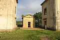
Attractions


The historic city center was declared an urban monument reserve in 1980 .
- Historic old town with "bird houses" (monument protection reserve)
- Ruins of the Helfenburg near Ostré
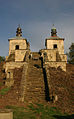
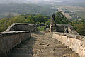
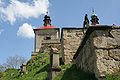
- The Neuländer Kapellenberg near Ostré (Neuland) has a height of 330 m and offers a good view over the Auscha basin to the Geltschberg . In the opposite direction, only the peak of the Vlhošť (Willhoscht) is visible. The two baroque chapels above a stone flight of steps, to which a way of the cross leads from Ostré, were built between 1703 and 1707 by the Leitmeritz master builder Octavio Broggio on behalf of the Jesuits zu Liebeschitz . After a last restoration in 1928, art abusers looted and destroyed the complex in the 1950s. The neglected Kalvarienberg was freed from wild trees and shrubs in 2005. There used to be a pilgrimage along the Way of the Cross for the Cross Finding Festival on May 3rd.
In the streets and alleys of the city center at Easter and August there are very attractive and well-attended "Old Bohemian Fairs", at which craftsmen (ceramists, basket weavers, glassblowers, blacksmiths, turners, beekeepers, plasterers, tailors, belters, etc.) offer their products.

Neuländer Kapellenberg, statue
New country Kapellenberg

View of the chapel mountain of Konojedy from

The church in Habrina has been covered again


.jpg)
.jpg)


- Panský dvůr Castle from the 14th century
- late baroque church of St. Peter and Paul (1764–1772)

- Pikart Tower, the mightiest and largest tower in the city fortifications (1428), today an exhibition room
- Deanery building the rectory
- Synagogue on Podskalská ulice and Jewish cemetery
- Gabled houses on the market square (Mírové náměstí)
- Jesuit Court
- Kudlichdenkmal


- Trinity Church
sons and daughters of the town
- Johann Absolon (* 1747), musician
literature
- Josef Jarschel: History of the city of Auscha . Verlag der Stadt, Auscha 1922 (325 pages).
Web links
Individual evidence
- ↑ http://www.uir.cz/obec/565814/Ustek
- ↑ Český statistický úřad - The population of the Czech municipalities as of January 1, 2019 (PDF; 7.4 MiB)
- ↑ Johann Gottfried Sommer : The Kingdom of Bohemia . Volume 1: Leitmeritzer Kreis , Prague 1833, pp. 340–341, item 32.
- ↑ Yearbooks of the Bohemian Museum of Natural and Regional Studies, History, Art and Literature . Volume 2, Prague 1831, p. 197, paragraph 14.
- ^ Meyers Großes Konversations-Lexikon 6th edition, Volume 2, Leipzig and Vienna 1905, p. 132 .
- ↑ a b Michael Rademacher: German administrative history from the unification of the empire in 1871 to the reunification in 1990. Leitmeritz district. (Online material for the dissertation, Osnabrück 2006).
- ↑ Czeski Urząd Statystyczny
- ↑ http://www.uir.cz/casti-obce-obec/565814/Obec-Ustek
- ↑ http://www.uir.cz/zsj-obec/565814/Obec-Ustek
- ↑ http://www.uir.cz/katastralni-uzemi-obec/565814/Obec-Ustek