
Mlékojedy
| Mlékojedy | |||||
|---|---|---|---|---|---|
|
|||||
| Basic data | |||||
| State : |
|
||||
| Region : | Ústecký kraj | ||||
| District : | Litoměřice | ||||
| Area : | 283.3213 ha | ||||
| Geographic location : | 50 ° 32 ' N , 14 ° 7' E | ||||
| Height: | 146 m nm | ||||
| Residents : | 226 (Jan 1, 2019) | ||||
| Postal code : | 412 01 | ||||
| License plate : | U | ||||
| traffic | |||||
| Street: | Litoměřice - Terezín | ||||
| structure | |||||
| Status: | local community | ||||
| Districts: | 1 | ||||
| administration | |||||
| Mayor : | Vladimír Kopřiva (status: 2007) | ||||
| Address: | Mlékojedy 41 412 01 Litoměřice 1 |
||||
| Municipality number: | 565296 | ||||
| Website : | www.mlekojedy.eu | ||||


Mlékojedy (German German Mlikojed ) is a municipality in the Czech Republic . It is located opposite Litoměřice on the Elbe and belongs to the Okres Litoměřice .
geography
The village is located below the confluence of the Eger on the left bank of the Elbe opposite the Leitmeritz sand island (Písečný ostrov). The Radobýl rises north-west across the river .
Neighboring towns are Litoměřice in the north, Želetice in the east, Terezín in the southeast, Nové Kopisty in the south, Lukavec and Lovosice in the southwest and Žalhostice in the west. The village of Prosmyky was located on the site of the Lovosice industrial area until 1950.
history
The village of Mlékovid was first mentioned in 1352 and belonged to various noble lords. There is evidence of a parish church since 1384. The place was sacked during the Hussite War. After 1500 the town of Litoměřice acquired the village of Mlékojedy . In 1592 a fire destroyed parts of the village and in 1595 the burnt-out church tower was renewed.
After 1600 the Leitmeritz councilor and poet Pavel Stranský von Stranka established his summer residence in Mlékojedy and acquired the Elbe island in the west of the town. In the Thirty Years' War (1618-1638) after the Battle of White Mountain, the town and Stranskýs property was confiscated. Stranský emigrated to Saxony in 1627. The Leitmeritzer Jesuits received his former lands. In 1631, Swedish troops devastated Mlékojedy and set fire to the village. In 1659 the town bought back its property in Mlikojed. During this time Mlikojed became a predominantly German-inhabited village. In the course of the Josephine reforms, the Jesuits' goods were sold. Some of them were handed over to the farmers by Deutsch Kopist , who had to leave their village and their land because of the construction of the Theresienstadt fortress .
On March 24, 1814, the wooden bridge over the Elbe was torn away during floods and ice. A ship mill was operated on the Elbe. The village flooded when the Elbe floods in 1845 . The volunteer fire brigade , founded in 1868, was the second in the entire district. The residents lived from agriculture or earned their bread in Leitmeritz and Lobositz. The school location was Prosmik and later Leitmeritz.
In 1880 there were about 400 inhabitants, 95% of whom were Germans. In 1881 the place name was extended to differentiate it from the village of the same name upstream of the Elbe with the addition of "German". In 1933 a mouse plague destroyed the crops in the fields and the following year a major drought followed. After the Munich Agreement, Deutsch Mlikojed, including its Eisendörfel district, was annexed to the German Reich in 1938 and belonged to the Leitmeritz district until 1945 . The place had 476 inhabitants in 1938, including 48 Czechs. Due to the flooding of the Elbe in 2002 , the place was again badly affected.
Local division
No districts are shown for the municipality of Mlékojedy.
Attractions
- Church of St. Martin, the originally Gothic building from the 14th century was redesigned in 1775 in Baroque style
- Rectory
- Statue of St. Florian

Main road
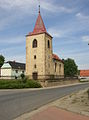
St. Martin Church

