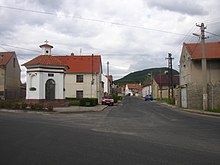
Vražkov
| Vražkov | ||||
|---|---|---|---|---|
|
||||
| Basic data | ||||
| State : |
|
|||
| Region : | Ústecký kraj | |||
| District : | Litoměřice | |||
| Area : | 762.203 hectares | |||
| Geographic location : | 50 ° 23 ' N , 14 ° 16' E | |||
| Height: | 205 m nm | |||
| Residents : | 421 (Jan 1, 2019) | |||
| Postal code : | 411 84 | |||
| License plate : | U | |||
| traffic | ||||
| Street: | D8 : Lovosice - Prague | |||
| Railway connection: | Roudnice nad Labem - Louny | |||
| structure | ||||
| Status: | local community | |||
| Districts: | 1 | |||
| administration | ||||
| Mayor : | Jaroslava Smetanová (as of 2012) | |||
| Address: | Vražkov 2 413 01 Roudnice nad Labem |
|||
| Municipality number: | 565881 | |||
| Website : | www.vrazkov.cz | |||
Vražkov (German Wraschkow ) is a municipality in the Czech Republic. It is located six kilometers south of Roudnice nad Labem and belongs to the Okres Litoměřice .
geography
The village is located at the southwestern foot of the Říp and is traversed by the Vražkovský potok. The route of the D8 / European route 55 leads past the western outskirts of Vražkov , the next exit 29 “Roudnice” is in the north. The railway line from Roudnice nad Labem to Louny runs through the village, where there is a train stop in Vražkov.
Neighboring towns are Vesce, Rovné and Krabčice in the northeast, Ctiněves in the east, Mnetěš in the southeast, Straškov-Vodochody in the southwest, Račiněves in the west and Kleneč in the northwest.
history
Vražkov probably originated in the middle of the 11th century. The first mention of the city was in one of Gustav Friedrich in 1907 in Volume 1 of the Codex diplomaticus et epistolaris regni Bohemiae evaluated collection of old and Soběslav II. Confirmed documents from the archives of the Vyšehrad Chapter, the Friedrich as deeds of vršovci from the time Bořivojs II . could be dated from 1100 to 1107. After the Vršovci were exterminated by Svatopluk II , the latter also acquired the property of Nemoj Vršovec in 1108 and Vrascov came to the Přemyslids . It is believed that the name of the place derives from its founders, the Vršovci.
Vražkov gradually became the property of intellectual masters. In 1174 the Vyšehrad Chapter owned the farm including a vineyard and from 1187 the Doksany Monastery received most of the village.
The northern district below the Říp belonged to various noblemen and a fortress has been documented there since 1440. In the Thirty Years' War the Saxons destroyed the village in 1631. At the same time, the festival fell into disaster. After Bohuchval Valkoun von Adlar had sold his property to the Dominican monastery Maria Magdalena on the Lesser Town , the village was repopulated between 1650 and 1652. In 1672 Wenzel Eugen Lobkowicz bought the northern part of his rule on Raudnitz . Until the abolition of patrimonial rule in 1848, there were two dominions, Raudnitz in the north and Doxan in the south. In 1850, 408 people lived in Vražkov who made their living from agriculture. By 1930 the population increased to 702.
Local division
No districts are designated for the municipality of Vražkov.
Attractions
- Baroque chapel on the village square, built in 1763
- Crucifix from 1846 and bell tower from 1920 at the bus stop on Dorfstrasse
Web links
Individual evidence
- ↑ http://www.uir.cz/obec/565881/Vrazkov
- ↑ Český statistický úřad - The population of the Czech municipalities as of January 1, 2019 (PDF; 7.4 MiB)


