Saupsdorf
|
Saupsdorf
City of Sebnitz
Coordinates: 50 ° 56 ′ 26 ″ N , 14 ° 19 ′ 52 ″ E
|
|
|---|---|
| Height : | 347 m |
| Residents : | 518 (Dec. 31, 2011) |
| Incorporation : | March 1, 1994 |
| Incorporated into: | Kirnitzschtal |
|
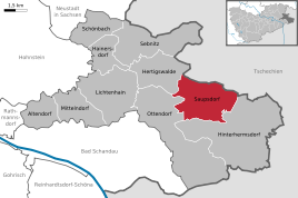
Location of Saupsdorf in Sebnitz
|
|
|
View from Weifberg to Saupsdorf
|
|
Saupsdorf is a district of the town of Sebnitz in the Saxon Switzerland-Eastern Ore Mountains district in Saxony .
history
First mentioned in documents which was then still the Kingdom of Bohemia belonging Waldhufendorf 1445 as Sawpirstorff under the suzerainty of Berka of Dubá . In 1451 the place came into the possession of the Wettins . Saupsdorf belonged to Sebnitz until 1702, then to Hinterhermsdorf. Lime was extracted at the beginning of the 17th century, which revived in the 19th century. With the shaft built in 1830, lime was mined until 1890. Around 1800 there was a stocking factory. On April 22, 1945, the death march from the Schwarzheide satellite camp reached Saupsdorf, where the prisoners slept in barns. The SS shot 6 prisoners. A tombstone in the cemetery still reminds of this today. On the April 23 branch, eight prisoners were executed by the SS at the Rölligmühle branch. A memorial stone commemorates the event.
On March 1, 1994, together with Lichtenhain and Ottendorf, the community of Kirnitzschtal was formed, which was incorporated into the city of Sebnitz on October 1, 2012.
Saupsdorf is a quiet place with almost 500 inhabitants, it lies on the border between the Elbe sandstone and the Lausitz granite , the transition from Saxon Switzerland to the Lausitz mountain and hill country. The village church, consecrated in 1842, which was renovated in 1902, several large farms, mills, timber-frame and half-timbered houses characterize this place on the 496 meter high Wachberg , also known as the “Swiss Crown”, which offers a far-reaching panorama of the rear Saxon Switzerland, the Bohemian Switzerland and ins Osterzgebirge with a good all-round view of the Thorwalder walls, over the Affensteine with the bare stick to the Schrammsteinen offers. The Wachberg probably got its name after the Thirty Years War, before it was called Butterbergk. On the Wachberg there has been a mountain chalet and guesthouse popular with hikers and day-trippers since 1851. The Wachbergbaude is open all year round and can be reached on foot or by car. The Panoramaweg and Prof.-Alfred-Meiche-Weg lead over the Wachberg.
Web links
- Homepage of the Saupsdorf Heimatverein
- Tourist information of Kirnitzschtal
- Kirnitzschtal at saechsische-schweiz.city-map.de
Individual evidence
- ^ Saupsdorf in the Digital Historical Directory of Saxony
- ↑ Landkreis Sächsische Schweiz , Meißner Druckhaus GmbH, Meißen, 1996, ISBN 3-9804714-1-1 , editor: Horst Torke
- ^ Saupsdorf in the Digital Historical Directory of Saxony
- ↑ Municipalities 1994 and their changes since January 1, 1948 in the new federal states , Metzler-Poeschel publishing house, Stuttgart, 1995, ISBN 3-8246-0321-7 , publisher: Federal Statistical Office
- ^ Saupsdorf in the Digital Historical Directory of Saxony
- ↑ Landkreis Sächsische Schweiz , Meißner Druckhaus GmbH, Meißen, 1996, ISBN 3-9804714-1-1 , editor: Horst Torke
- ^ Saupsdorf. In: www.saupsdorf.de. Retrieved October 31, 2016 .


