
Česká Kamenice
| Česká Kamenice | |||||
|---|---|---|---|---|---|
|
|||||
| Basic data | |||||
| State : |
|
||||
| Historical part of the country : | Bohemia | ||||
| Region : | Ústecký kraj | ||||
| District : | Děčín | ||||
| Area : | 3876.5784 ha | ||||
| Geographic location : | 50 ° 48 ' N , 14 ° 25' E | ||||
| Height: | 301 m nm | ||||
| Residents : | 5,247 (Jan 1, 2019) | ||||
| Postal code : | 407 21 | ||||
| License plate : | U | ||||
| traffic | |||||
| Railway connection: |
Děčín – Jedlová Česká Kamenice – Česká Lípa |
||||
| structure | |||||
| Status: | city | ||||
| Districts: | 10 | ||||
| administration | |||||
| Mayor : | Hana Štejnarová (as of 2018) | ||||
| Address: | náměstí Míru 219 407 21 Česká Kamenice |
||||
| Municipality number: | 562394 | ||||
| Website : | www.ceska-kamenice.cz | ||||
| Location of Česká Kamenice in the Děčín district | |||||

|
|||||


Česká Kamenice (German: Böhmisch Kamnitz ) is a town in the Děčín district in the Aussiger district in the Czech Republic .
geography
Geographical location

The city is located in northern Bohemia on the Kamnitz (Kamenice) at the transition from Bohemian Switzerland to the Lusatian Mountains .
City structure
The town consists of the districts Česká Kamenice ( Böhmisch Kamnitz ), Dolní Kamenice ( Niederkamnitz ), Filipov ( Philippsdorf ), Horní Kamenice ( Upper Kamnitz ), Huníkov ( Henne ), Kamenická Nová Víska ( Kamnitz-Neudörfel ), Kerhartice ( Gersdorf ), Líska ( Hazel ), Pekelský Důl ( Hellgrund ) and Víska pod Lesy ( forest villages ). Basic settlement units are Česká Kamenice-střed, Dolní Kamenice, Filipov, Horní Kamenice, Horní Kamenice-východ, Huníkov, Huníkov-sever, Jehla ( Nolde ), K Janske, Kamenická Nová Víska, Kerhartice, Lířalkou, Pod hý Ský Dbitůl., , Podtretí, Pod Zeleným vrchem, U nemocnice, U papíren, Víska pod Lesy, Za nádražím and Zámecký vrch.
The municipality is divided into the cadastral districts of Česká Kamenice, Dolní Kamenice, Horní Kamenice, Kamenická Nová Víska, Kerhartice and Líska.
history


In the middle of the 13th century, German colonists founded the elongated forest hoof village of Kamenice on the river of the same name. Kamenice was first mentioned in documents in 1352. King Ottokar II had already given the central part of the village town privileges - the suburbs of Ober- and Niederkamnitz were formed from the rest of the village.
At the end of the 13th century, King Wenzel II left the town to Johann von Michelsberg - under him the town came under the rule of Scharfenstein . Johann III. von Michelsberg gave the citizens the right to revert in 1383. Later, the city also received brewing rights, in 1394 beer and wine licensing rights and market rights. The Jakobskirche had its own pastor as early as 1384. The Michelsbergers were followed by the Berken von Dauba in 1406 and the Wartenberger in 1428 .
High war debts and the declining power caused the Wartenbergers to sell the rule to the Lords of Salhausen from the Mark Meissen in 1515 . These divided the rule in 1535. The Kamnitz rule, which had belonged to the Kinsky since 1614 and existed until 1850, was founded from one part . With the construction of the castle and the Lady Chapel in the 17th century, Kamenice developed into a representative baroque town. As a result of the re-Catholicization, there was a peasant uprising in 1625. The Kamenice residents also took part in the peasant uprisings of 1680 and 1775. During the Thirty Years' War there was a big fire in the town in 1634, caused by stationed Austrian troops. Swedish troops left their mark ten years later. In addition, the city suffered from the floods of 1656, 1677 and 1753, the plague in 1713 and another city fire in 1778.
Handicraft has been documented as early as 1389. Kamenice had one of the first glass-refining craftsmen in the 17th century. With the construction of a paper mill in Ober-Kamnitz in 1834, the industry began to develop. Weaving mills, spinning mills, machine works, iron foundries, glass refineries and a furniture and knitwear factory followed. The railway line of the Bohemian Northern Railway from Bodenbach to Warnsdorf , opened in 1869, promoted the upswing, which was reflected in the municipal aqueduct that opened in 1894 and the power station that went into operation in 1900.
In 1919 Kamenice was assigned to Czechoslovakia . In 1921 the place had 4539 inhabitants, of which 4,295 (95%) Germans, and in 1930 4,538 inhabitants, of which 252 (6%) Czechs.
With the Munich Agreement , Böhmisch Kamnitz fell to the “ German Reich ” from 1938 to 1945 - to the district of Tetschen-Bodenbach , district of Aussig , in the Reichsgau Sudetenland .
After the end of the Second World War it was back to Czechoslovakia. A large part of the German-speaking population was subsequently expropriated and expelled .
Trivia
In 1833 the robber Wenzel Babinsky was up to mischief and murdered the Hirschfeld weaving factor Johann Gottfried Blumberg in the forest between Oberkamnitz and Hasel .
Population development
Until 1945, Böhmisch Kamnitz was predominantly settled by German Bohemia , which were expelled .
| year | Residents | Remarks |
|---|---|---|
| 1818 | 2 202 | in 314 houses |
| 1830 | 2,312 | in 338 houses |
| 1832 | 2 231 | in 317 houses |
| 1857 | 3 188 | on October 31st |
| 1900 | 4 872 | German residents |
| 1921 | 4,539 | thereof 4,295 (95%) Germans |
| 1930 | 4 790 | according to other data, 4,538 inhabitants, of which 252 (6%) are Czechs. |
| 1939 | 4 357 | |
| 1945 /46 |
0 |
The Sudetes, "cleared" after the Second World War, were only gradually settled after a few years.
| year | Residents | Remarks |
|---|---|---|
| 1970 | 5 477 | |
| 1980 | 5 585 | |
| 1991 | 5 646 | |
| 2001 | 5 492 | |
| 2003 | 5,475 |
Rabstein factories
Between 1860 and 1867 Franz Preidl built the Rabsteiner Fabriken (also Preidl Fabriken in Rabstein) in the valley of the Kamnitz (Kamenice) - three textile spinning mills near Nieder-Kamnitz (Dolní Kamenice), Kamnitz-Neudörfel (Kamenická Nová Víska) and Jonsbach ( Janská ).
Weser-Flugzeugbau GmbH
During the Second World War , tunnels were driven into the sandstone cliffs on Johnsbacher Flur under the code name Zechstein . Weser-Flugzeugbau GmbH (WFG) from Bremen started its production of accessories for the Junkers dive fighter planes (Stuka), which had been outsourced from Bremen, both in the old spinning mill and in underground rooms in the rocks .
Rabstein subcamp
From the end of August 1944 to May 8, 1945, there was a satellite camp of the Flossenbürg concentration camp , whose 650 prisoners had to do forced labor for the Bremen-based company Weser-Flugzeugbau . The prisoners were used to develop an underground aircraft plant. The concentration camp satellite camp also had the code name Zechstein . 59 prisoners perished in the concentration camp. At the end of the war there were still around 1,500 prisoners in the barracks. Apart from a few foundation walls, nothing has survived from the concentration camp .
On May 8, 1945, the camp was evacuated towards Wernstadt. When they slept in a barn, the guards escaped the next morning and the inmates were free.
Eviction, collection point
After the end of the war, the former Rabstein spinning mill No. 59 was used as a collection point for the expelled Germans until 1946.
Twin cities
- The twin town Bad Schandau in the German state of Saxony is about 22 km as the crow flies from Česká Kamenice.
Culture and sights


- The castle gate is a remnant of the former city wall that enclosed Česká Kamenice in the Middle Ages. The Church of St. Jacob the Elder is the oldest town church, the foundation walls of which date from the 14th century. Opposite this church is
- The castle, which was built between 1541 and 1543 and has since been changed several times. The Marienkapelle, probably by Octavio Broggio , was built between 1736 and 1739, the Salhausen-Schlösschen in 1521 and the town hall in 1491. Until 1946 it belonged to Prince Kinsky .
- The Jehla (Nolde) is a mountain near Česká Kamenice. Some gems have been created in the sandstone cliffs on its slopes. The best known is the Brothers Altar (Bratrský oltář).
- On the nearby Schlossberg are the ruins of the medieval Kamnitz Castle with a newly built observation tower
- At Horní Kamenice ( Oberkamnitz ) is the pottery stone (Hrnčíř), a prominent rock, around which several legends entwine.
- At Líska ( Hazel ) is the Zlatý vrch ( Goldberg ), a basalt peak whose columnar structure with the lava plug on top was exposed by quarrying activities and which is now a nature reserve .
- Four kilometers northeast of Česká Kamenice is the striking mountain Studenec ( Kaltenberg ). Since its renovation in 2009, the iron observation tower on the summit has been accessible again.
- The 4,5 km long, opened in 1996 Museum railway to Kamenický Šenov ( Steinschönau ) originally belonged to the Society of the Bohemian Northern Railway (BNB) and was opened 1886th Passenger traffic ended in 1979 and the line had been completely closed since 1992. (See also: Local Railway Böhmisch Leipa – Steinschönau )
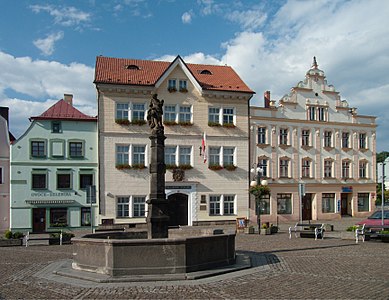
Town hall and fountain on Friedensplatz

Kamenický hrad ruin


sons and daughters of the town
- Johannes Klein (1684–1762), astronomer, mathematician and designer
- Joseph Rothe (1759–1808), opera singer and actor
- Jakob Frint (1766–1834), theologian and bishop
- Johann Baptist Emanuel Pohl (1782–1834), Austrian botanist
- Friedrich Marian (1817–1869), chemist
- František Hegenbarth (1818–1887), cellist and music teacher
- Emanuel Hegenbarth (1868–1923), painter
- Josef Hegenbarth (1884–1962), painter and graphic artist
- Hannes Hegen (1925–2014), graphic artist and comic artist
- Heribert Wenzel (1929–2017), politician (SPD), member of the Hessian state parliament
- Rainer Eckert (* 1931 in Hasel / Líska), Baltist and Slavist
- Helmut Schmidt (* 1943), scientist and politician (SPD)
- Gisela Weiß (* 1943), swimmer
- Sigurd Hofmann (* 1944), scientist, physicist
Web links
Individual evidence
- ↑ http://www.uir.cz/obec/562394/Ceska-Kamenice
- ↑ Český statistický úřad - The population of the Czech municipalities as of January 1, 2019 (PDF; 7.4 MiB)
- ↑ http://www.uir.cz/casti-obce-obec/562394/Obec-Ceska-Kamenice
- ↑ http://www.uir.cz/zsj-obec/562394/Obec-Ceska-Kamenice
- ↑ http://www.uir.cz/katastralni-uzemi-obec/562394/Obec-Ceska-Kamenice
- ↑ a b Jaroslaus Schaller : Topography of the Kingdom of Bohemia . Volume 5: Leutmeritzer Kreis , Vienna 1787, pp. 211–212, item 1).
- ↑ Franz Aloys Mussik: The Schönlinde market and its eingepfarrte villages. In addition to a brief outline of the dominions of Böhmisch-Kamnitz, Hainspach, Schluckenau and Rumburg. A historical-topographical attempt . Prague 1828, pp. 117-139.
- ↑ a b c Ernst Pfohl: Ortlexikon Sudetenland. Helmut Preußler Verlag-Nürnberg. 1987. Page 39. ISBN 3-925362-47-9
- ^ A b Rudolf Hemmerle: Sudetenland Lexikon Volume 4, page 81. Adam Kraft Verlag, 1985. ISBN 3-8083-1163-0 .
- ↑ Franz Aloys Mussik: The Schönlinde market and its eingepfarrte villages. In addition to a brief outline of the dominions of Böhmisch-Kamnitz, Hainspach, Schluckenau and Rumburg. A historical-topographical attempt . Prague 1828, p. 136.
- ↑ Yearbooks of the Bohemian Museum of Natural and Regional Studies, History, Art and Literature . Volume 2, Prague 1831, p. 197, paragraph 9) below.
- ↑ Johann Gottfried Sommer : The Kingdom of Bohemia . Volume 1: Leitmeritzer Kreis , Prague 1833, pp. 255-256, item 1).
- ↑ Statistical overviews of the population and livestock in Austria . Vienna 1859, p. 40, left column .
- ^ Meyers Großes Konversations-Lexikon 6th edition, Volume 3, Leipzig and Vienna 1905, p. 162 .
- ^ A b Michael Rademacher: German administrative history from the unification of the empire in 1871 to the reunification in 1990. Tetschen district (Czech: Decín). (Online material for the dissertation, Osnabrück 2006).
- ↑ Czech population statistics , on czso.cz
- ^ Rabstein satellite camp (Rabštejn) Cover name: »Zechstein«. ( Memento of the original from July 7, 2016 in the Internet Archive ) Info: The archive link was automatically inserted and not yet checked. Please check the original and archive link according to the instructions and then remove this notice. Website of the Flossenbürg Concentration Camp Memorial. Retrieved July 6, 2016.