Dobkovice
| Dobkovice | ||||
|---|---|---|---|---|
|
||||
| Basic data | ||||
| State : |
|
|||
| Region : | Ústecký kraj | |||
| District : | Děčín | |||
| Area : | 574.5215 ha | |||
| Geographic location : | 50 ° 43 ' N , 14 ° 11' E | |||
| Height: | 150 m nm | |||
| Residents : | 652 (Jan. 1, 2019) | |||
| Postal code : | 407 03 | |||
| License plate : | U | |||
| traffic | ||||
| Street: | Ústí nad Labem - Děčín | |||
| Railway connection: | Prague – Děčín | |||
| structure | ||||
| Status: | local community | |||
| Districts: | 3 | |||
| administration | ||||
| Mayor : | Michal Faltus (as of 2018) | |||
| Address: | Dobkovice 101 407 03 Dobkovice |
|||
| Municipality number: | 562408 | |||
| Website : | www.dobkovice.cz | |||
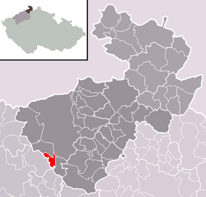
| Location of Dobkovice in the Děčín district | ||||

|
||||
Dobkovice (German Topkowitz ) is a municipality in the Czech Republic . It is located nine kilometers south of the city center of Děčín and belongs to the Okres Děčín .
geography
Geographical location
Dobkovice is located between Ústí nad Labem and Děčín in the Bohemian Central Uplands on the left bank of the Elbe at the confluence of the Poustka and Maškovický creeks. To the north rises on the opposite side of the Elbe valley the Dívčí skok (Jungfernsprung) , east of the Vrabinec ( sparrow stone, 350 m), in the southeast the Poklona (465 m) and in the south the Stříbrný roh (516 m) and the Lícha (462 m) ). To the left of the Elbe are the Bradlo (453 m) in the southwest, the Hora (497 m) in the west and the Petrův vrch (437 m) in the northwest.
Community structure
The municipality Dobkovice consists of the districts Dobkovice (Topkowitz) , Poustka (Pauska) and Prosetín (Prosseln) . Basic settlement units are Dobkovice and Prosetín. The settlement of Skrytín (Skritin , also Reichberg) belongs to Dobkovice .
The municipality is divided into the cadastral districts Dobkovice and Prosetín u Dobkovic.
Neighboring communities
Neighboring towns are Nové Choratice and Nebočady in the north, Smordov, Všeraz and Hoštice nad Labem in the north-east, Jakuby and Přední Lhota in the east, Těchlovice in the south-east, Skrytín, Zadní Lhota and Roztoky in the south, Maškovice and Prosetín in the west and Borekin in the north-west.
history
The first written mention of the village Dobkowycz , which originally belonged to the Svádov rule and thus belonged to the Teplice Benedictine monastery, was made in 1374. The village, which emerged from eight farms and a mill, originally extended in the Maškovický potok valley. At the end of the 14th century, the village was divided, with a portion of the Schreckenstein reign and in 1383 another smaller part went to the lords of Těchlovice. The latter was attached to the Děčín reign in 1430 , and with the merging of the Děčín and Děčín reigns in the 15th century, the Děčín part also came to Děčín. The monastic part came to the Teplitz rule after the destruction of the Teplitz monastery. In 1831 there were 279 people in Topkowitz.
After the abolition of patrimonial , both parts of Topkowitz (Dubkovice) were united and from 1850 the place formed with Rongstock a political municipality in the district administration of Tetschen. With the railway line of the Imperial and Royal Northern State Railway from Aussig (Ústí nad Labem) to Bodenbach, which was put into operation in 1851 , Topkowitz was expanded north into the Elbe Valley and a settlement was established around the Topkowitz-Kartitz railway station. After the seat of the community was initially relocated from Rongstock to Topkowitz, the two places separated in 1870 and formed their own communities. In the 1870s there was a mill, a sawmill, a paint factory and the Stolle shipyard in Topkowitz. The M. Korálka button factory was established in 1893 and ceased operations in the 1930s together with another button factory founded in 1918. The parish was Neschwitz (Nebočady) , but three houses in the village belonged to the parish in Rongstock. In the first half of the 20th century, numerous handicraft businesses emerged. In 1910 Topkowitz had 1145 inhabitants. In 1918 a Czech minority school was established. In 1930 the municipality of Topkowitz, including the districts of Skritin, Zechenhäusel and Laubhöhe, had 630 inhabitants. After the Munich Agreement , the municipality was added to the German Reich in 1938 and belonged to the Tetschen district until 1945 , and from 1943 Tetschen-Bodenbach . In 1939 there were 564 people in Topkowitz. In 1945 Dobkovice returned to Czechoslovakia and the German residents were expelled . In 1949 Prosetín, Borek, Choratice and Nové Choratice were incorporated. In 1961 Poustka was also part of Dobkovice, and at the same time Choratice and Nové Choratice were amalgamated into Malšovice . Borek was also outsourced to Malšovice in 1971. In August 2002 Dobkovice was largely flooded by the flood of the century .
Culture and sights
- Vrabinec rock peak with the remains of Sperlingstein Castle, on the opposite side of the Elbe
- Chapel in the forest near Skrytín
- Dívčí skok (Jungfernsprung) with a railway tunnel, on the right bank of the Elbe near Nebočady
Web links
Individual evidence
- ↑ http://www.uir.cz/obec/562408/Dobkovice
- ↑ Český statistický úřad - The population of the Czech municipalities as of January 1, 2019 (PDF; 7.4 MiB)
- ↑ http://www.uir.cz/casti-obce-obec/562408/Obec-Dobkovice
- ↑ http://www.uir.cz/zsj-obec/562408/Obec-Dobkovice
- ↑ http://www.uir.cz/katastralni-uzemi-obec/562408/Obec-Dobkovice

