
Biela (Elbe)
|
Biela Bělá |
||
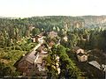
 The Biela between Ottomühle and Schweizermühle |
||
| Data | ||
| Water code | DE : 537132 | |
| location | Czech Republic ; Saxony , Germany | |
| River system | Elbe | |
| Drain over | Elbe → North Sea | |
| source | In the sandstone cliffs of Eiland 50 ° 48 ′ 2 ″ N , 14 ° 3 ′ 5 ″ E |
|
| Source height | approx. 520 m nm | |
| muzzle | In Königstein in the Elbe coordinates: 50 ° 55 '10 " N , 14 ° 4' 28" E 50 ° 55 '10 " N , 14 ° 4' 28" E
|
|
| length | approx. 18.6 km | |
| Discharge at the Bielatal 1 A Eo gauge: 37.61 km² Location: 7.8 km above the mouth |
NNQ (08/11/2004) MNQ 1965/2010 MQ 1965/2010 Mq 1965/2010 MHQ 1965/2010 HHQ (08/13/2002) |
99 l / s 197 l / s 349 l / s 9.3 l / (s km²) 3.92 m³ / s 24 m³ / s |
| Right tributaries | Cunnersdorfer Bach | |
| Small towns | Koenigstein | |
| Communities | Rosenthal-Bielatal | |


The Biela ( Bělá in Czech ) is a left tributary of the Elbe in the Elbe Sandstone Mountains .
Course and origin
The river, first mentioned in 1412 as the Bela , rises as Hammerbach at an altitude of 520 meters in the sandstone cliffs of Eiland (Czech Ostrov ) in Bohemian Switzerland (source: 50.080 ° N; 14.051 ° E) , flows in a northerly direction and already reaches a few kilometers of the Saxon area . There the Hammerbach joins the Dürren Biela, which rises on the Hohe Schneeberg , near the village of Sněžník (Schneeberg). The river flows in a northerly direction towards the Elbe until it makes a turn to the northeast in a wide loop just before the mouth. After 18 kilometers, the Biela flows into the Elbe on the left at 115 m above sea level in Königstein .
geomorphology
As a result of the elevation of the Erzgebirgsscholle , which also tilted the western part of the Elbe Sandstone Mountains , the Biela shows a significant difference in altitude of around 400 meters from the source to the mouth. The gradient is responsible for increased erosion , which led to the formation of bizarre sandstone rocks on the valley slopes.
Water condition
For a long time the Biela is a near-natural stream with a sandy bottom and clear water. The banks are built only in the local areas. The brook meanders in places in the sole notch valley it has formed. In the Biela floodplain, birch and black alder break forests have developed in places.
Bielatalbahn
In July 1901 the company for trackless railways Max Schiemann & Co. of the Dresden engineer Max Schiemann opened one of the world's first trolleybus routes, the Bielatalbahn , in the Bielatal . The 2.8-kilometer route led from Königstein via Hütten to the then Königsbrunn spa , also known as the Königsbrunn cold water sanatorium . Due to a lack of profitability, the line was closed again in September 1904.
Mills and hammer huts
In the past, the water power of the Biela was used by numerous mills and hammer mills . The valley gained importance in the past as a site for smelting plants for the magnetite extracted around Berggießhübel . The Bielatal was preferred as a hut location because the river has a high and relatively even water drainage. The oldest known facility up to now was the Hammerhütte Brausenstein, which was mentioned in a document as early as 1410 as a successor property. The Brausenstein blast furnace, built around 1700, is today the only surviving material evidence of the production technology of hammer metallurgy in the entire area of the so-called Pirnisch Eisen . Overall, the following hammer huts existed along the Biela from the source to the mouth (operating times in brackets):
- Eiland ( Ostrov u Tisé ) (before 1515 to around 1650)
- Rosenthal-Bielatal: Ottomühle (1548 former grain mill, today an inn & hostel)
- Rosenthal-Bielatal : Oberhütte (before 1452–1726, later the cold water sanatorium Schweizermühle )
- Rosenthal-Bielatal: Brausenstein (before 1410–1750)
- Rosenthal-Bielatal: Neidberg (before 1470–?)
- Rosenthal-Bielatal: Reichstein (1494–1705)
- Hütten : Middle Reichhammer (before 1445–1680)
- Hütten: Unterer Reichhammer (before 1445–1640)
- Hütten: Greifenhammer (before 1445–1649)
- Huts: Alte Gießhütte (1541 to after 1586)
Most of the plants had to stop operating at the end of the 17th and beginning of the 18th century due to the devastation of the forest and the increasing prices of charcoal . Today the Louisenthal paper mill , a subsidiary of the Giesecke & Devrient Group, produces banknotes and securities at the Alte Gießhütte site in Hütten .
After Schober there were the following mills in the Bielatal:
- Worm or worm mill
- Otto mill
- Swiss mill
- Parisius mill
- Brausensteiner Mill
- Reichsteiner Mill
- Hofemühle Hermsdorf
- Paper mill huts
- Schinkemühle huts
- Zeibigmühle huts
- Reicheltmühle Koenigstein
- Hofemühle Koenigstein
- Obermühle or Hintermühle Königstein
- Königstein bee mill
- Nieder- or Brückmühle Königstein
as well as at the Cunnersdorfer Bach
- Obermühle Cunnersdorf
- Mittelmühle Cunnersdorf
- Cunnersdorf ham mill
- Hüttenhofmühle Cunnersdorf
and at the Leupoldishainer Bach
- Leupoldishainer Mill Leupoldishain
- Nikolsdorf Mill Nikolsdorf
Hammer mills and mills on the Biela and its tributaries
Swiss mill around 1900

Otto mill (front right)

Brausenstein blast furnace


Flood
In the past, the valley of the Biela was repeatedly hit by floods, often in connection with Vb weather conditions , which discharged as heavy rain over the Eastern Ore Mountains. On November 15, 1552, 107 people are said to have died in the floods of a sudden flood of the Mühlwasser (Biela) in the Königstein area. Another flood destroyed numerous mills and hammer mills on May 28, 1617. A bridge and seven houses were destroyed in Königstein. During the flood on 29./30. In July 1897, numerous bridges and weirs were destroyed, and large sections of the valley road were destroyed. A man was killed in huts. The flood of the century in August 2002 caused damage of € 24 million in the Biela catchment area.
Climbing sport
The erosion on the valley slopes, which in some cases gave rise to bizarre sandstone cliffs, is responsible for the development of the popular Bielatal climbing area . The current climbing guide lists 239 climbing peaks in the German part of the Biela valley alone, with several hundred trails of all levels of difficulty, further climbing peaks can be found in the Bohemian part of the valley.
Large parts of the Bielatalfelsen have been moved to great depths and tilted. The formation of the tectonic clefts reaching up to 45 meters in depth can also be traced back to this process of rock dissolution. The most famous of these caves is the Benno cave , which is accessible to visitors , but is only a little more than 13 m deep.
_Panorama_(01-2).jpg)
See also
Individual evidence
- ↑ Length of the brook at OSM
- ↑ Hydrological Handbook. (PDF; 637 kB) Part 3 - Main aquatic values. Free State of Saxony - State Office for Environment and Geology, p. 63 , accessed on December 25, 2017 .
- ^ Gunter H. Schmidt: Vom Pirnischen Eisen. From the history of the old hammers and huts in the Pirna area. Pirna 1984, p. 11
- ^ Gunter H. Schmidt: Vom Pirnischen Eisen. From the history of the old hammers and huts in the Pirna area. Pirna 1984, p. 82
- ^ Manfred Schober: Mills in Saxon Switzerland
- ^ Anonymous: The great water shortage in Saxony in 1897. Described according to reports by eyewitnesses. Reprint of the original edition from 1897, Husum 2002, p. 7ff.
- ^ Saxon State Office for Environment and Geology: Event analysis of floods in August 2002 in the rivers of the Eastern Ore Mountains. Management report. Dresden 2004, p. 6
literature
- Carl Merkel: Biela or description of western Saxon-Bohemian Switzerland. A paperback for friends of the great outdoors. Bischofswerda 1825
- Gunter H. Schmidt: From the Pirnischen Eisen. From the history of the old hammers and huts in the Pirna area. Pirna 1984
- Harald Schurz : On the trail of the old ironworks and hammers in the Bielatal. in: Working group Saxon Switzerland in the Landesverband Sächsischer Heimatschutz eV [Ed.]: Communications. Issue 2. Pirna 2005, pp. 26-28
- Roland H. Winkelhöfer: Through caves in Saxon Switzerland. DER CÖHLENFORSCHER publishing house, Dresden 2010