
Cross-border mining nature trail
The cross- border mining nature trail (Příhraniční naučná hornická stezka) Graupen (Krupka) - Geising - Altenberg - Zinnwald - Bohemian Zinnwald (Cínovec) - Eichwald (Dubí) is a 40 km long mining trail in the Upper Eastern Ore Mountains . It connects seventy material witnesses (especially museums, monuments, visitor mines, artificial ponds and trenches, heaps and tourist attractions) of the history of mining and settlement. The nature trail thus describes the development history of what was once the most important tin mining area in Central Europe. We recommend purchasing a hiking map for hiking, which contains detailed maps as well as brief descriptions of the route points and the opening times of the museums.
_2006-06-28.jpg)
Geographical location
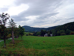
The nature trail is about 45 km south of Dresden in the upper Eastern Ore Mountains. It is located directly on the Czech border and leads from Graupen (Krupka) via Obergraupen (Horni Krupka), the Mückenberg (Komáří hůrka), Voitsdorf (Fojtovice) to Fürstenau (hiking trail in the small border traffic ). From Fürstenau the path continues via Löwenhain , Geising , Altenberg to Zinnwald . Graupen (Krupka) is reached again via the old border crossing on the B 170 via Vorderzinnwald (Prední Cínovec). The nature trail thus cuts through the source area of the Weißen Müglitz .
Route points
Pearl barley (krupka)

- 01 - The chairlift to the Mückenberg (Komáří hůrka) is the longest chairlift without an intermediate station in the Czech Republic . At the time of its construction, it was even the longest chairlift in Central Europe . The cable car was built from 1950 to 1952 under a Swiss license and is 2,348 m long.
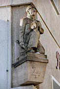
- 02 - The Calvary (Kalvárie) is a rock hill above the map Mariaschein (Bohosudov). In connection with the pilgrimage tradition to the Mariaschein pilgrimage church, a baroque chapel was built here in the middle of the 18th century . Since 1761 there has been an artistically crafted figure of Christ inside.
- 03 - The pilgrimage church of Our Lady of Sorrows in Mariaschein (Bohosudov) probably dates back to the Hussite battle near Aussig (Ústí nad Labem) in 1426. The current baroque building goes back to the redesign by the builders Giulio Broggio and Octavio Broggio . It is one of the most beautiful sacred buildings in the Czech Republic.
- 04 - The St. Anna cemetery church was built in 1516 in a simple style with great sympathy from the Graupener citizens. Your equipment includes u. a. a rare depiction of Martin Luther from the 16th century.
- 05 - The Spitalkirche (Heilig-Geist-Kirche) was formerly connected to the city hospital . It was first mentioned in a document in 1454 as an already existing church. After a fire (1538) it was rebuilt in 1556–1642.
- 06 - Graupen Castle (Hrad Krupka) was a strategically important castle, which protected the mines , the city and the old trade route to Saxony . It was probably built around 1300. It was first mentioned as an already existing castle in a deed in 1330. In the Hussite Wars, the complex was destroyed in 1429 and then rebuilt between 1434 and 1440. A late Gothic renovation took place in 1471–1482 . In the Thirty Years War it was again destroyed. The Bergamtshaus was built on the courtyard between 1695 and 1697. The castle itself had already been abandoned and fell into disrepair.
- 07 - The city church of the Assumption of Mary is the city parish church of Graupens . Its origin dates back to the 2nd half of the 14th century. In 1429 it was destroyed in the Hussite War and rebuilt from 1430 to 1440. After a city fire (1479) it was rebuilt in the late Gothic style for the second time within a short period of time in 1479–1488 and later redesigned in baroque style.
- 08 - The ringing tower , a free-standing tower with a stone substructure and a clapboard roof, is one of the few originally preserved mining bell towers in Europe . It was built in the early 15th century. It was given its current form around 1600. The bell tower signaled the miners that the shift was about to begin or end.
- 09 - The historic market square of Graupen has an elongated shape. The listed building ensemble was created in the Middle Ages by widening the former Kolditz-Straße. Graupen itself was established as a miners' settlement around 1230, became a free mining town in 1300 and a royal free mining town in 1547.
- 10 - The Graupen Museum was founded in 1919 by the local museum association and was originally located in the house of the former school. Today the collections (inter alia on mining and natural history) are housed in a town house from the Renaissance period .
- 11 - The gallery of the “Alter Martin” visitor mine was one of the most important tunnels in the Graupen district when it was in operation. He opened up the north-western part of the Luxer Ganges (Czech: "Lukaš"). With a length of about 2 kilometers, it is the longest tin-bearing ore vein in the Czech Republic.
- 12 - The miners' settlement of Obergraupen (Horni Krupka) below the Mückenberg was founded in 1370. It was created when the miners in search of another tin - soaps up the valley covered the mountains.
- 13 - The St. Wolfgang Chapel is located about 300 meters west of the Mückenberg at an altitude of 774 meters. The original chapel , dating from 1360 , was dedicated to St. Wolfgang, the patron saint of miners. It was destroyed in the Thirty Years War and rebuilt in the baroque style in 1692–1700.
Mosquito turrets on the Mückenberg

Pilgrimage Church of Mariaschein

View to Graupener Castle

"Alter Martin" visitor mine


_Blick_zur_Burg.jpg)

Mückenberg (Komáří hůrka)

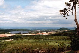
- 14 - The Mückenberg (807 m above sea level ) is one of the highest mountains in the Eastern Ore Mountains on the territory of the Czech Republic . At the turn of the 12th to the 13th century, the area around Graupen was one of the most important tin mining areas in Europe. The search for further tin ore deposits brought miners to the Erzgebirgskamm am Mückenberg in the 14th century. Mining on the Mückenberg was first mentioned in a document in 1416.
Fürstenau

- 15 - The settlement area Fürstenau was probably created during the first clearing time of the eastern Ore Mountains , in the second half of the 13th century as a rural settlement. The church, visible from afar, with its pointed steeple, was built in 1885–1887 as a new building for the dilapidated old church from around the 14th century.
- 16 - The silver mine was created in the hope of finding silver , copper and lead ores in the 17th century. The tunnel was operated several times for a short time, but always without result. The oldest written evidence of the mine comes from 1687.
Geising
The mountain settlement of Geising dates back to the 14th century. An iron ore mine was mentioned here in 1375 and a forge in 1449. The mining itself was less significant in the place than in neighboring Altenberg and Zinnwald. However, the ores extracted in these two locations were processed in Geisinger Hüttengrund, as Altenberg and Zinnwald lacked the necessary water to operate the wet pounding works and ore washing . Active mining in Geising was stopped in the middle of the 19th century. The opening of the Müglitztalbahn brought the city new development impulses in tourism from 1890 onwards. Today, the Geisingen city center is a historical and well-preserved mining settlement and is largely a listed building.
- 17 - Hüttenteich : The Hüttenteich was created in 1755–1757 by damming the Hüttenbach. It served as a water reservoir for driving the water wheels in the Geisinger Erzwäschen , wet pounding works and smelting works . After mining stopped, the water was used to power sawmills and lathes for local turners . In 1952, a natural ice rink for speed skating competitions was set up on the site . Today the area is used as an outdoor swimming pool and leisure center.
- 18 - Ice rink : The ice rink was built in 1950 as a natural ice rink . It was the first of its kind in the Ore Mountains and was located next to the former Geisinger Schanzen and the newly built sports hall. The stadium was modernized in the 1990s and later covered. It is used as an artificial ice rink in winter. It is also used as a venue for Geisingen concerts.
- 19 - Evangelical Church : The Evangelical Church has already been mentioned. In 1484 the foundation stone was laid for a late Gothic new building, which was consecrated in 1513 by the abbot of the Altzella monastery . The church, which had become too small, was replaced by a new building in 1689–1694. Its interior was decorated with tin from the Eastern Ore Mountains and houses, among other things, a valuable altar with miner's chandeliers.
- 20 - Ratskeller : The house on the former Neumarkt was built after 1700 by the later miner Grundig by rebuilding two dilapidated houses. After Grundig's death (1729) Rudolf von Bünau became the owner. He used the house from 1736 as the seat for the vassal mining office of his rule Lauenstein, which had existed since 1475 . With the end of Bünau's rule on Lauenstein, the mining office also changed hands in 1823, but retained its function. It was only dissolved in 1851 in the course of declining mining.
- 21 - String maker house : The string maker house was originally built around 1480. The current shape comes from a renovation in 1686, during which the half-timbered upper floor and the Renaissance seat niche portal were created. In the hall of the house there is a hanging scale from 1692 and a relief picture with two miners. The respected tin merchant Wendisch once lived here. Between 1692 and 1902 the house served as a workshop for pewter casters. The name was derived from a long-time owner family.
- 22 - City Hall : In contrast to many city hall buildings in the area, the new building from 1910 was not built in the classical style, but adapted to the character of the city with its rich historical building fabric.
- 23 - Zwitterstock-Tiefer-Erbstollen : This 1,978 m long tunnel, which was driven between 1491 and 1543 to a depth of 133 m under the bed of the Altenberg Roman shaft , served to drain the Altenberg pits. It was created on the initiative of Elector Friedrich the Wise . The cities of Freiberg, Dresden and Leipzig as well as the monasteries and cathedral chapters Freiberg, Meißen and Altzella had to take over the financing. The construction of the tunnel was pushed forward on both sides. However, they did not meet at the same height, so that there is an approx. 3 m high waterfall inside the mountain. In addition, a plaque reminds of the visit to the tunnel by Prince Friedrich August in 1822. The Erbstollen drained the Altenberg pits until 1982.
- 24 - Atonement Cross : The atonement cross located at the western exit of the village bears the representation of a sword bent at the tip. It probably dates from the pre-Reformation period and was probably erected around the beginning of the 16th century.
- 25 - House "Anno 1497" : The house "Anno 1497" is considered the oldest preserved house in Geising. This is evidenced by the date 1497 carved on the door stone. According to unsecured traditions, the house is said to have been built by a member of the Kölbel family. A renovation carried out in 1768 fundamentally changed the upper floor. Today the house houses a restaurant called "Anno 1497".
- 26 - Tiefenbach waterfall : In 1953, a large rinsing dump was built in the Tiefenbach valley for the intensified mining industry after 1945. By relocating the stream around the rinsing dump , an artificial, 20 m high, imposing waterfall was created, which can be reached via a path.

View from the Kohlhaukuppe
Hüttenteichbaude and Geisingberg

Tiefenbach waterfall


Altenberg
In the first half of the 15th century, miners from Graupen pushed further and further from the south to the heights of the Eastern Ore Mountains in search of further tin deposits. They discovered the Altenberg deposit between 1436 and 1440, which soon led to the founding of the mining town. Tin mining determined the development of the place for a period of 550 years. Research has shown that the Altenberg deposit is the most important tin deposit in Europe. The dismantling was stopped here in 1991 due to a lack of profitability. Since the 15th century, a total of 106,000 tons of tin (in concentrate) have been extracted, including around 39,000 tons between 1947 and 1991. The long-standing mining has left numerous objects in the city and the surrounding area, of which the pinge is the largest monument.
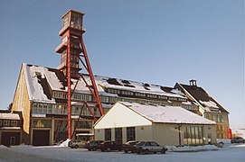
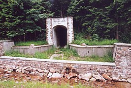
- 27 - Mining Museum Altenberg : The mining museum is the former “IV. Zwitterstock union laundry ”, whose roots go back to the 16th century. It is the last remaining ore wash of an extensive system of earlier processing plants that were located in the valley of the Tiefenbach between Altenberg and Geising. The museum opened in 1957. It shows the historical processing of the tin ore based on the original operating principles with stamping mill and long-pusher hearth . In 1971 the museum was expanded to include a show tunnel. In the "Neubeschert-Glück-Stollen" excavated in 1802, workplaces are recreated which document the mining and mining technology of the past 500 years. In 1994 the museum was expanded to include an open space that v. a. Shows mining equipment from the last 50 years of mining.

Mining museum
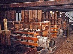
Stamp mill in the mining museum
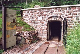
Oral hole of the "Neubeschert Glück Stollen"

in the "Neubeschert Glück Stollen"
_2006-06-28.jpg)
_2006-06-28.jpg)
_2006-06-28.jpg)
_2006-06-28.jpg)
_2006-06-28.jpg)
- 28 - Mining memorial stone : According to legend , in 1458 a charcoal burner found "clearer" tin while clearing his kiln . He had unexpectedly erected his pile on a mighty flat vein. The heat of the kiln had melted tin from the stones he used as a base. In memory of the 400th anniversary of the first ore discovery, the memorial stone was erected in 1858. Today we know that mining began between 1436 and 1440. The memorial stone was originally located 200 m further west of the current location in the fracture area of the Pinge. That is why it was moved to its current location at the mining museum.
- 29 - Weather shafts : The two through bay building protected wells Weather "Überhauhen 20" (1966) and "Überhauhen 32" (1974) were used for ventilation in the last period of Altenberger mining. They supplied the pit with fresh air and removed pollutants such as rock dust, explosive gases and ionizing radiation , which are caused by radon and radon derivatives. The city of Altenberg is currently (status 10/2006) working on a project to make this radiation usable through radon cures . The two buildings are among the few surviving weather shaft buildings in the Ore Mountains.
- 30 - Pulverhaus : The powder house is not far from the weather shaft "Überhauhen 20". The use of gunpowder for drilling and blasting work in Altenberg has been proven since 1668, but due to the high costs, this extraction method only gained acceptance slowly. In 1793 the massive powder house was built at a safe enough distance from the city area. It was used to safely store gunpowder until the second half of the 19th century.
- 31 - Markscheidestein : A copy of a Markscheidestein erected in 1811 is located between the Pinge and the Geisingberg . It shows the mine field boundary between the mining companies "Union Rothe-Zeche-Fundgrube" and "Union Zwitterstocks Deeper Erbstolln". It was set up after the settlement of a dispute between these two companies and separated the fields with the respective mining authorization.
- 32 - Zwitterweg : The Zwitterweg is an earlier road that was used for the transport of the tin-containing rock, which the miner also called the Zwitter . It led from the “Rothzechner Treibeschacht” for processing to the Rothzechner Pochwäschen near Geising .
- 33 - Rothzechner Treibeschacht : In 1472 miners struck gold in the pits at the so-called “Neufang” east of today's Pinge . In contrast to the compact hermaphrodite, mining on ore veins was predominant there. The Rothzechner drive shaft was sunk from 1793 and was until 1866 the main shaft of the mining company "Union Rothe-Zeche-Fundgrube". Then it served as an escape and weather shaft . The shelter that exists today was built in 1954.
Arno-Lippmann-Schacht
View of the Pinge , in the background the Geisingberg
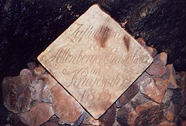
Commemorative plaque for the war year 1813
_2005.jpg)

_2006-06-28.jpg)
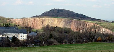
- 34 - Altenberger Pinge : A large part of the tin ore in Altenberg does not occur as a dike , but as a continuously finely mineralized stick . That is why the miners use the method of expansion construction by means of fire for mining . In the process, however, the mining area was undermined to such an extent that the remaining pillars could not withstand the pressure of the overlying overburden. From 1545 the first widenings broke and a subsidence field, called pinge in mining, developed on the surface . There were further breaks until 1619, some of which were provoked by the mine owners. The largest break occurred in 1620. It destroyed 36 pits and left a 2-hectare collapse funnel. The continued dismantling resulted in controlled subsequent breaks. Today the Pinge covers an area of 12 hectares at a depth of 150 m and a diameter of 450 m. The pinge is one of the most important national geotopes in Germany.

- 35 - Meridian stone : The meridian stone available as a copy represents the zero point of a local coordinate network for the mapping of the Altenberg mine systems. With its help, the compass needle deviation caused by the migration of the magnetic pole could be determined. The stone was also the reference point for the local height measurement.
- 36 - Cannonball : In the course of the retreat of allied Russian, Prussian and Austrian troops after the Battle of Dresden , it occurred in the vicinity of Altenberg on 29./30. August 1813 to violent fighting with the advancing French troops. The city was largely destroyed and the powder house (see route point no. 30) was blown up. The inhabitants fled u. a. into the mines. To commemorate the fighting, a howitzer's ball was built into a retaining wall.
- 37 - Bergmannsbrunnen : The Bergmannsbrunnen was inserted into a retaining wall by French prisoners of war in 1941/42. His relief shows three miners at work underground. The insignia of the Altenberg mining industry can be seen under the relief .
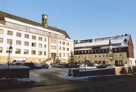
- 38 - City center of Altenberg : The old Altenberg city center was largely destroyed by Soviet troops in the last days of the Second World War . Air attacks and arson took place between the 7th and 10th centuries. May 1945 over 140 buildings in ruins. The reconstruction in the early 1950s offered the opportunity to design a completely new city center. The new residential and administrative buildings around the central place of the miner (including mine administration, town hall since 1994) combine the modernity of the time with numerous Ore Mountains and mining details.

Saxon post mile column (1722)

Relief at the miner's well
City center, on the left the town hall
Detail of a house in the city center
_2005.jpg)
_2005.jpg)
_2005.jpg)
_2005.jpg)
_2005.jpg)
- 39 - Post mile pillar and milestone : On Bundesstrasse 170 there is a Saxon post mile pillar built in 1722 . In their immediate vicinity there is a royal Saxon station stone built in 1860/61. Both stones were used to mark postal rates.
- 40 - Römerschacht : At the beginning of the 19th century, new shaft breaks in the area of the pinge made it necessary to sink a new main shaft. Therefore, from 1837, the shaft named after the mountain commissioner Jobst Christoph von Römer was sunk. It was the last main shaft of the Altenberg Zwitterstock that was sunk directly into the deposit. In 1850, the mining began from the 237 meter deep shaft, with which the productivity could be increased significantly. The Römerschacht was used for ore mining until the Arno-Lippmann-Schacht opened in 1963 (see route point 49), after which it was used for ventilation until 1992 . The characteristic headframe had to be demolished in 1989 due to its dilapidation.
- 41 - Max-Nacke-Gedenkstein : The memorial stone, erected in 1964, commemorates the famous native singer and folk poet Max Nacke (born April 26, 1883, † August 8, 1958). Coming from a miner's family, Nacke was the founder of the nationally known Nacke trio.
- 42 - Church of Altenberg : The old church, built in 1878, was destroyed in the last days of the Second World War (see route point 38), the ruins were removed in the 1950s. It was not until 1984 that the decision to build a new church was made. This was inaugurated in December 1991 after two years of construction. With its 34 m high church tower it is a new landmark of the city.
- 43 - Skier memorial: The memorial today at the train station was inaugurated in October 1931. The original location was next to the primary school. The monument is intended to document the importance of Altenberg as a winter sports center in the Eastern Ore Mountains.
- 44 - Train station : Altenberg has been the terminus of the Müglitztalbahn leading to Heidenau since 1923 . The station building was built in the late 1930s when the line was converted from narrow gauge to standard gauge . It is considered the most beautiful station building of the Müglitztalbahn.
- 45 - Gallows ponds : The large and small gallows ponds were built in the middle of the 16th century (probably 1550–1553). The water of the storage basin supplied u. a. the driving skills , served the dewatering and supplied the wet pounding works with a sufficient and continuous amount of water. The at 790 m above sea level. NN located ponds are the highest artificial ponds in the Ore Mountains. The name comes from a gallows that used to stand here.
- 46 - Neugraben : The 7 km long Neugraben, together with the cross ditch (see route point 47), forms part of the 30 km long artificial ditch system, which was created for the water supply to the gallows ponds (see route point 45). The tributary established in 1550/54 collects the surface water flowing off from the Kahleberg and the Georgenfelder Hochmoor .
View of the gallows ponds
Marrow stone
The Aschergraben near Altenberg


.JPG)
- 47 - Cross ditch : The 3 km long cross ditch was also created in 1559/60 to supply water to the gallows ponds (see route point 45).
- 48 - Walkteiche : The artificial ponds , also known as “felt ponds” , were probably created as early as 1450. Their water was used as impact water to drive the mining facilities.
- 49 - Arno-Lippmann-Schacht : The continued dismantling of the fracture masses of the pinge (route point 34) inevitably expanded and deepened it. In order to be able to achieve the long-term mining target of 1 million t of raw ore per year, it was necessary to sink a new production shaft at a suitable distance from the hermaphrodite, which is at risk of breaking. Therefore, from 1952 a new central shaft was sunk directly on the B 170. This 296.7 m deep shaft replaced the Römerschacht (route point 40) in 1963 and was named after the Zinnwald anti-fascist Arno Lippmann in 1966. The Lippmann shaft remained in operation until the mining industry was closed in 1991. During this time 19 million tons of raw ore were extracted from it. In the course of the renovation of the Altenberg mining facilities, the tunnel was sealed, the central building with the 40 m high winding tower is now used commercially as part of the "Europapark Altenberg".
- 50 - Black pond : The black pond was created in the first period of Altenberg tin mining in the 15th century. It was used to supply the Erzwäschen with water.
- 51 - Aschergraben : The artificial moat , built between 1452 and 1458, is one of the technical masterpieces from the early days of Altenberg mining. The 7.4 km long trench led with a gradient of up to 0.6% impact water from the ridge area west of Zinnwald to the Altenberg stamping works and smelting works.
- 52 - Goethe Monument : Between July 10 and 12, 1813, Johann Wolfgang von Goethe went on an excursion to Zinnwald and Altenberg. After examining the Zinnwald dump, he walked the path along the Aschergraben to Altenberg on July 11th. Goethe himself wrote about it: We now hiked the mountain ditch, which directs the water from these heights, as it comes from the stamp mills, to Altenberg. As usual, it stretches along the ridge and the path is very pleasant because it always goes through forest. The monument was erected in 1913 to commemorate Goethe's visit to the Aschergraben.
- 53 - Historic bobsleigh run : The natural ice bobsled run built in 1907/08 below the Aschergraben and extended to up to 2,200 m in 1910/12 was used for competitions until 1930.
Zinnwald-Georgenfeld
Mining activities on the ridge of the Osterzgebirge can be traced back to the year 1378. It was Graupener miners who discovered the tin deposits stored here and built them. They also gave the entire mountain area, which stretched northwest from Graupen to Moldau (Moldava), the name Cynwald . Later this name was transferred to the immediately neighboring mining towns of Saxon Zinnwald (today Zinnwald-Georgenfeld) and Bohemian Zinnwald (today Cínovec). At these two locations, mining was finally stopped in the Saxon part in 1945/46 and in the Bohemian part in 1990. The mining of the neighboring Altenberg was never able to reach the size of the mining industry because of the smaller ore deposits and the political division of the deposit.
Mouth hole of the "deeper help God tunnel"

Remnants of the processing plants of "Stahlwerke Becker AG"

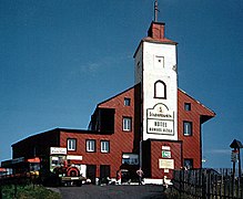
Zinnwald visitor mine

former museum hut house
_2006-06-28.jpg)
_2006-06-28.jpg)
_2006-06-28.jpg)
,_Museum_Huthaus.jpg)
- 54 - The sand dumps were created from 1917 onwards as slopes of residual materials from ore mining.
- 55 - The deeper help God tunnel was driven forward 1801–1868. As the deepest tunnel in the area, it drained the pits below the "Tiefen-Bünau tunnel" (route point 57).
- 56 - Stahlwerk Becker AG from Willich took over the conveying and processing plants in 1915 and carried out extensive expansion work. The processing was mechanized and the extensive use of electrical energy was introduced. Along the road to Geising some (unused) buildings from the former processing plant are still preserved.
- 57 - The Zinnwald visitor mine emerged from the "Tiefen Bünau tunnel" that was excavated around 1550. The tunnel, named after the lords of Bünau , was used for drainage and was used as a road and transport route. In 1992 a spatially extensive visitor mine was opened here. A nearly three-kilometer circular trail incurred by the fire set in tin mining augmentations , which are among the most accessible of its kind in the Erzgebirge.
- 58 - The Pels laundry and sand dumps were created through the mining activities of the metal traders Siegfried and Albert Pels from Hamburg. In 1904 they founded a new exploration in the grace of God. In addition to the sinking of the Rosa Pels shaft and the expansion of the Josef gallery, a new ore processing facility was built in a modern design at the time.
- 59 - Gasthof Sächsischer Reiter : The inn, built in 1697 in a central location, was the most famous stop in Zinnwald. The most famous guest was Goethe , who stayed here while visiting the pewter mines of Altenberg and Zinnwald from July 10th to 12th, 1813. A memorial plaque on the house reminds of his stay. The inn has been empty since 1990 and is increasingly falling into disrepair.
- 60 - Haspelkaue on the Commun shaft : On the access path to the “Huthaus” museum (route point 61) is the Commun shaft, which was sunk in the Middle Ages and is 29.7 m deep down to the “Oberen-Bünau-tunnel”, an inheritance ditch from the 16th century. A replica of a bucket with a hand reel was built above the shaft in 1985 . The Zinnwald mining industry used such shaft chews until 1922.
- 61 - former Huthaus Museum : The local history and mining museum was located in a building erected as a forge in 1756 , which has been used as a hut house by the Vereinigt Zwitterfeld Fundgrube since 1842 . After the merger of the Zinnwalder collieries, the building came into the possession of the Union of Zwitterfeld and Erbstolln in 1853 , which converted it into the central administration building and named it Reicher Trost after a nearby pit . The building has been a listed building since 1913 . In 1983 the local history museum was set up here. The exhibition mainly provided information about the development of tin mining and the everyday life of miners. The museum was closed in 2010 due to low visitor numbers.
- 62 - Evangelical Church : The Protestant exiles who fled the Bohemian part of Zinnwald for reasons of faith in the 17th and 18th centuries did not have a place of worship in Zinnwald itself. The Protestant community of Zinnwald-Georgenfeld belonged to the Geisingen parish until the beginning of the 20th century. Only in 1908/09 was a church built in Zinnwald itself as a counterpart to the Catholic church in Bohemian Zinnwald. Three years later, the parish of Geising gained its independence. The architectural style of the church, with its walls, the massive tower and the far lowered roof, adapts to the harsh climate on the Ore Mountains ridge.
- 63 - Boundary stone from 1673 : In front of the Huthaus Museum (route point 61) is the original of a boundary stone, which marks the point where the domains of von Bünaus on Lauenstein (Bünau coat of arms with the leopard heads), von Sternbergs in Graupen (Krupka) (coat of arms marked with the gold star) and the electoral office in Altenberg (Saxon coat of arms with cursory swords) ( Dreiherrenstein ). The Zinnwald deposit extended over these three domains, with about two thirds being accounted for by the Bohemian part. The boundary stone was set up in connection with measurements for the construction of the Georgenfeld refugee settlement (route point 64). The "division" of the Zinnwald deposit into several domains prevented large-scale production and was a major reason why mining in Zinnwald never reached the order of magnitude of the production in neighboring Altenberg.
- 64 - The establishment of the Georgenfeld refugee settlement was approved by Elector Johann Georg II of Saxony in 1671 at the request of the Altenberg Office . This allowed Protestant exiles from the neighboring Bohemian parts of Zinnwald to settle on the St. Georgenfelde along the border. The majority of the religious refugees continued to work in the Bohemian mines.
Bohemian - tin forest
,_D_und_CZ_Kirche.jpg)
- 65 - The military shaft was created in 1915 through the expansion of the “Köppenschacht” (“Köpfenschacht”) with the aim of modernizing and centralizing the mining facilities of the Bohemian Zinnwald. After dismantling was stopped in 1990, the daytime facilities were demolished in 2011.
- 66 - The Catholic Church was founded as an independent parish in October 1728 in the course of the Counter Reformation.
- 67 - The long pond was artificially created in 1787 as a water reservoir for the Bohemian ore processing.
- 68 - A dead girl was found on the Zinnwalder Berg (880 meters above sea level), also known as the “dead child”, which is why the area used to be called “Am toten Kind”.
Vorderzinnwald (Prední Cínovec)
- 69 - Vorder-Zinnwald was founded in the 15th and 16th centuries. Founded in the 16th century from Graupen .
- 70 - The robbery castle (757 m above sea level) is located on a wooded hilltop on the south-western flank of Lysá hora (Kahler Berg) on the southern slope of the Ore Mountains ridge. The summit is bounded by a ditch, archaeological excavations took place at this point as early as 1904. Excavations from 1976 brought to light other finds such as ceramic shards, iron objects (nails, horseshoes, wedges and arrows) as well as a mold made of red sandstone for pewter rods. These ceramic finds indicate a settlement period from the 2nd half of the 14th century to the beginning of the 15th century.
advancement
The project was funded by:
- EU Community Initiative Interreg III A
- Euroregion Elbe / Labe
- Ostsächsische Sparkasse Dresden
In addition, between 1997 and 2000, around 1.6 million euros were invested in the maintenance and expansion of mining equipment in the upper Eastern Ore Mountains within the framework of the EU programs Interreg II and PHARE / CBC.
literature
- Wolfgang Barsch et al .: The Erzgebirge tin in nature, history, technology. Altenberg 1988.
- Around Altenberg, Geising and Lauenstein (= values of the German homeland . Volume 7). 1st edition. Akademie Verlag, Berlin 1964.
- Martin Hammermüller: Altenberg - Geising - Zinnwald. Series of our little traveling booklet Vol. 27. Leipzig 1954.
- Bernhard Jasmand [Ed.]: Goethe. Excursion to Zinnwalde and Altenberg. Dresden 1949.
- Egbert Kamprath: Altenberg. Pictures of a city. Dresden 1999.
- Heinrich Kromayer: Altenberg-Zinnwalder mining with special consideration of its development since the middle of the last century. unpublished Dissertation. Jena 1925.
- Sächsisches Oberbergamt / Sächsisches Landesamt für Umwelt und Geologie [Hrsg.]: The tin deposit Altenberg. Series Mining in Saxony, Vol. 9. Dresden 2002.
- Christoph Schröder: Description of the Altenberg tin storey by Johann Carl Schütz from the year 1789. Kleinvoigtsberg 1999.
- Rudolf Schumann : Manuscripts of the mining history of the Osterzgebirge. (Ed. by the Knappenverein Altenberg eV). Kleinvoigtsberg 2003.
- Otfried Wagenbreth et al .: Mining in the Ore Mountains . Technical monuments and history. Ed .: Otfried Wagenbreth, Eberhard Wächtler . 1st edition. German publishing house for basic industry, Leipzig 1990, ISBN 3-342-00509-2 , p. 504 .
Web links
General
- Homepage Cross-border mining nature trail (with interactive maps)
- Ulrich Haag: "Mining without borders - the cross-border mining educational path Krupka - Geising - Altenberg - Zinnwald / Cinovec - Dubi" ( Memento from October 5, 2007 in the Internet Archive )
- Elbe-Labe Euroregion
Route points in Graupen (Krupka)
- City of Krupka (Czech)
- Krupka Castle (Czech) (route point 6)
- Visitor mine "Alter Martin" Krupka (Czech) (route point 11)
- Mückenberg (Czech) (route point 14)
Route points in Geising
- City of Geising
- Hüttenteich (route point 17)
- Ratskeller (route point 20)
- Atonement Cross (route point 24)
- House "Anno 1497" (route point 25)
Route points in Altenberg
- Mining Museum Altenberg (route point 27)
Route points in Zinnwald
- Zinnwald visitor mine (route point 57)
Notes and sources
- ↑ Jasmand 1949, p. 8