
Georgenfelder Hochmoor
|
Georgenfelder Hochmoor nature reserve
|
||
 Entrance to the nature reserve |
||
| location | Saxony , Germany | |
| surface | 11 ha | |
| Identifier | D 46 | |
| WDPA ID | 9363 | |
| Geographical location | 50 ° 44 ' N , 13 ° 45' E | |
|
||
| Setup date | 1961 | |

The Georgenfelder Hochmoor is a high moor in the Ore Mountains not far from Zinnwald-Georgenfeld . It is part of a larger moor complex that is located to the south, especially on the other side of the state border in the Czech Republic and has been known as "The Sea" since ancient times. The Georgenfelder Hochmoor is one of the oldest nature reserves in Saxony .
geography
location
Zinnwald-Georgenfeld, located directly on the German-Czech border , is about 45 kilometers south of Dresden and four kilometers south of Altenberg . The on the ridge plateau of the Osterzgebirge in 780 to 880 m above sea level. NN lying scattered settlement is the highest place in the eastern Ore Mountains. The Georgenfelder Hochmoor is part of this community.
The nature reserve covers about 11 hectares and is located at an altitude of 875 m above sea level . It is only the small western tip of an extensive moor area between the German and Czech Lugsteins.

Georgenfelder Hochmoor nature reserve

Bohlenweg in the Georgenfelder Hochmoor, immediately to the right of the path is the German-Czech border

Still waters in the Georgenfelder Hochmoor, in the background the transmission tower on the Lugstein can be seen
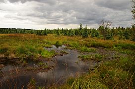
Still waters in the nature reserve Georgenfelder Hochmoor

Open meadow area with cotton grasses
.jpg)
.jpg)
.jpg)


Origin, age and profile
The formation of the raised bog dates back to the Elster Ice Age . At that time , the maximum extent of the inland glaciation extended to the Feuersteinlinie , which runs from Tharandt - Rabenau - Freital - Kreischa - Weesenstein - Cottaer Spitzberg in the district of Saxon Switzerland-Eastern Ore Mountains .
The local mountain ridge wore a permanent snow cap . When this cap melted, small lakes formed in the hollows that had no drains. In the warm period that followed the Ice Age, vegetation formed on the edge of these waters. The reeds and horsetail formed the first humus and initiated the formation of bog. Falling leaves , pollen, and blown grass collected in the water . Thousands of years later, the pollen trapped in the bog still allows an exact determination of the vegetation and climate prevailing at that time .
The following dry and warm climatic period allowed these reed bogs to dry out. Individual trees, especially birches , settled in these nutrient-rich areas. This period was followed by a cool, humid period with little sunshine. The enormous rainfall increased the water balance immensely, which is why species of peat moss settled very quickly , which owing to their rapid growth displaced the trees and ultimately suppressed them completely. The dead trees were hermetically sealed under the moss. Today this layer is also known as old forest peat . The peat moss dies from below and continues to grow indefinitely upwards. This created a thick layer of peat. The surface of this vegetation is strongly curved towards the middle, which is why it is called a raised bog. The geographical location of this Moores has thus the term high not moor in common, since it is also in the lowlands are raised bogs.

The subsequent moderately dry climatic period resulted in renewed tree cover in the area. The bog pine settled there . The pitted mosses formed the older moss peat . Afterwards it became cool and damp again, the mosses replaced the trees. These dead trees are now known as the younger forest peat layer.
In our current temperate and dry climate, trees such as bog pines settled again.
In the course of time, several moors have formed on the eroded plateaus of the Ore Mountains . These usually also form the watersheds .
Half-ripe moss peat forms a layer of 8 cm in 100 years. During this time, ripe moss peat forms a layer two to three centimeters thick. The Georgenfelder Hochmoor is around 5 meters thick, so its age can be assumed to be around 10,000 years.
Another moor area in the immediate vicinity is the Fürstenauer Heide NSG .
Today's vegetation
The water balance of the area was disturbed by the intensive peat cut, which resulted in the death of some plant species. Today the cranberries and trunks from the northern European tundra still settle. The bog pine is predominant, but some white birch and spruce have also settled. The bog pine comes from the mountain pine that lives in the high mountains. In the Georgenfeld high moor it is usually found as a knee-high shrub, mountain pine or curved pine; with these growth forms it has adapted perfectly to the rough climate of this mountain range. Blueberries, heather and lingonberries can be found on the dried up areas. The cotton grass, on the other hand, has colonized the damp areas.
The following plants can also be found in the nature reserve: sedges, peat moss, cotton grass, sundew and butterwort.
Protected plants

( Czech ), Latin
- Marsh pine, Pinus uncinata
- Downy birch Betula pubescens
- Dwarf birch (Bříza zakrsla)
- Peat moss Sphagnidae
- Blueberry (borůvka černá)
- Swamp porst Rhododendron tomentosum
- Cutting cotton grass (suchopýr pochvatý)
- Narrow-leaved cottongrass (suchopýr úzkolistý)
- Round-leaved sundew (rosnatka okrouhlistá)
- Spotted orchid
- Cranberry (Brusinka)
- Bogberry or dark berry
- Cranberry
- Heather
- Marsh violet , Viola palustris
- Pipe grass
- European seven star
- Arm-flowered sedge
meaning
The moor fulfills the same task as the glaciers in the high mountains, it absorbs the abundant water from the snowmelt and heavy downpours and slowly releases it again during the dry season. The Georgenfelder Hochmoor is able to absorb 1300 liters of water per square meter. It feeds the Warmbach to the northwest . In the heyday of mining, many kilometers of artificial trenches were dug to the moors to meet the immensely increasing demand for water. The artificially created gallows pond in Altenberg was created on a moor very similar to the Georgenfeld high moor. As a result of the intensive peat digging for fuel production, large bog areas have dried out and have been transformed into heather areas.
Development and protection position

The area was purchased in 1926 on an initiative of the Saxon Heritage Protection Association and declared a nature reserve. The senior teacher Marschner particularly highlighted himself in this purchase and the botanical research. The Saxon botanist Hofrat A. Naumann, associate professor of botany at the University of Veterinary Medicine in Dresden , also undertook intensive research in the Georgenfeld raised bog. The moor was made accessible through the creation of a long boardwalk.
The Georgenfelder Hochmoor is now the core area of a total of 35 hectares that is protected as a Natura 2000 area. The moor itself is designated as a nature reserve to an extent of 12.45 hectares. The protection status is based on the fact that the Georgenfeld high moor is the only larger ridge high moor in the Eastern Ore Mountains and forms the habitat for numerous endangered animal and plant species.
The management of the moor is carried out by a non-profit GmbH on behalf of the city of Altenberg. The facility is open between Easter and October (as of 2014). In 2014 the Georgenfelder Hochmoor had 17,500 visitors (2013: 15,000 visitors).
literature
- Green League Eastern Ore Mountains: NSG Georgenfelder Hochmoor . Series of nature reserves in the Eastern Ore Mountains, Dippoldiswalde 2015 ( digital copy )
- A. Naumann: From the history of our moors. In: Messages from the Saxon Homeland Security Association. Issue 1/2, 1927.
- Karl Tröger: Protection of our Georgenfeld high moor . District Commission for Friends of Nature and Homeland in the German Cultural Association, Dippoldiswalde district.
- Günter Weise: The Georgenfelder Hochmoor. A journey through its flora. In: Local history sheets of the Dresden district. 1956.
Web links
- Raised bog information
- Information on the Georgenfelder Hochmoor
- Information on the Natura 2000 area Georgenfelder Hochmoor
Individual evidence
- ↑ Borovice blatka in the Czech language Wikipedia
- ↑ Bříza pýřitá in the Czech language Wikipedia
- ↑ A. Naumann (PDF)
- ↑ More visitors to the raised bog. In: Saxon newspaper. (Dippoldiswalde edition) from November 26, 2014.


At the gallows pond Altenberg | Mountain meadows in the Eastern Ore Mountains and Fürstenau Heath | Dresden Elbe Valley slopes | Geisingberg | Georgenfelder Hochmoor | Gimmlitztal | Gimmlitzwiesen | Bullfinch catch | Border meadows Fürstenau and Fürstenauer Heide | Holy Halls | Stumbling block | Hochstein - Karlsleite | Hofehübel Bärenfels | Luchberg | Märzenbecherwiesen in Polenztal | Low mountain range around Oelsen | Middle Seidewitztal | Müglitzhang near Schlottwitz | Pfaffenstein | Rabenauer reason | Schwarzbachtal | Reasons to save at Dohna | Trebnitzgrund | Unger | Weicholdswald | Weißeritztal slopes | Weißeritzwiesen Schellerhau | Wesenitzhang near Zatzschke | Windberg