
Windberg (Freital)
| Windberg | ||
|---|---|---|
 |
||
| height | 353 m | |
| location | Free State of Saxony , Germany | |
| Mountains | Döhlen basin | |
| Coordinates | 50 ° 59 '49 " N , 13 ° 39' 39" E | |
|
||
| rock | Conglomerate with coal seam | |
| Age of the rock | Rotliegend | |

The Windberg (353 m above sea level ) is located in the urban area of Freital near Dresden in the Free State of Saxony and is considered the city's local mountain . The mountain is the namesake of the Windbergbahn , the first German mountain railway .
Surname
There are currently only various hypotheses on this. By folk etymological derivation and changes, vineyards or pastures are conceivable, but the hypothesis of a derivation from Windenberg or Wendenberg seems more likely . The Sorbs living in this area can be assigned to the Wends , to which a considerable part of the toponyms of this area can be traced back.
Geomorphology and natural features
The Windberg has a distinctive silhouette that can be seen from afar. The narrow north-westerly rise is followed by a long, broad and densely forested plateau. The mountain has been designated as a nature and landscape protection area since 1967 because of its near-natural forest cover and the rich flora and fauna. The tectonic rift cave Windbergspalte , located on the northern flank of the mountain, is the deepest cave in Saxony with a depth of 44 meters. A genetically similar crevice zone is located on the southern flank, but this is not passable for humans.
Flora and fauna
The slopes of the ridge on the northwestern edge of the Eastern Ore Mountains flank of the Windberg are planted with a large-scale and supraregional significant stock of sessile oak and beech forests and provide a habitat for a large number of endangered animal species. Bats and numerous species of birds use the extensive forest biotopes. The strictly protected greater mouse-eared ( Myotis myotis ), the endangered stag beetle ( Lucanus cervus) and the priority species of the Habitats Directive counting Spanish flag (Euplagia quadripunctaria) occur in the natural habitats of the wind mountain. The Windberg is also of particular interest to avifaunists. Besides black woodpecker ( Dryocopus martius ), gray-headed woodpecker ( Picus canus ), red-breasted flycatcher ( Ficedula parva ) colonize Honey Buzzard ( Pernis apivorus ) and Dove ( Columba oenas ) the ecologically valuable landscape area. The inconspicuous smooth snake ( Coronella austriaca ) and widespread sand lizard ( Lacerta agilis ) occur in the warm upper slope with the dry formation of the grove-sessile oak forest.
Mining
_Huthaus_Windbergschacht_(01-2).jpg)
The mountain itself was shaped by the coal mining of the 19th century. On the long flanks of the mountain with its full plateau-like shape are numerous heaps , but also naturally formed depressions and fractures. In the vicinity of the mountain there are numerous former mining tunnels , for example the Segen-Gottes-Schacht , the Neuhoffnungsschacht , the Glückauf-Schacht , the Marienschacht and the Augustusschacht .
On the summit plateau of the Windberg itself was the Windbergschacht , which was operated by the Potschappler Aktienverein from 1845. The shaft was sunk to a depth of 412 meters. In 1857 it was connected to the Windbergbahn , in 1881 the operating time ended. The hut house, which is currently used as an animal shelter, was preserved from the once structurally extensive shaft system. On the eastern Windberg plateau (formerly also Kieferberg) there is a memorial in memory of the victims of the firedamp explosion in the Segen-Gottes- und Neuhoffnungsschacht of 1869 .
Paths to the summit
The ascent from the south towards Niederhäslich and from the north towards Burgk leads over steep hiking trails through beech , especially hornbeam , and oak forests . Coming from the east in the direction of Bannewitz , you can get to the King Albert Monument , which is located high above Freital , without having to negotiate major differences in altitude .
view
From the Windberg you have a view to the south, west and north. Over the Weißeritztal lying at the foot of the mountain with the city of Freital, formed in 1921/24 from six communities with its numerous railway and industrial facilities, the view extends to the Tharandt forest , the Eastern Ore Mountains and the Dresden Elbe valley .
Others
- The typical northern silhouette of the Windberg is visible on numerous cityscapes of Dresden . A more recent example is the cityscape from 1756 in the Panometer with the virtual location of the Catholic Court Church .
- The King Albert monument is located on the Windberg.
- The traditionally well-attended cross-country run "Around the Windberg" has taken place on the Windberg every year since 1950.
gallery

The Windberg on a drawing from 1799

Detail from an overview map from 1895 with Windberg

Topographic map of the Windberg from 1930 with elevation profile
historical map of the Windbergbahn with the Windberg in the right part of the picture

View from Freital- Wurgwitz to the Windberg

Weinbergschlösschen Jochhöh in Pesterwitz with the Windberg in the background

King Albert Monument (state before renovation)
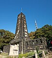
King Albert Monument after renovation (2011)


_K%C3%B6nig-Albert-Denkmal_(02-2).jpg)
Individual evidence
- ↑ Saxon cave cadastre no.5047 / EG-12
- ^ Karl Mannsfeld and Olaf Bastian: Saxon Landscapes: Between Dübener Heide and Zittauer Gebirge . Ed .: Sächsische Landesstiftung Natur und Umwelt, Naturschutzfond. 1st edition. Edition Leipzig, Leipzig 2012, ISBN 978-3-361-00678-2 , pp. 29 f .
- ^ Dresden regional council: Ordinance of the Dresden regional council establishing the nature reserve "Windberg Freital". November 12, 2001. Retrieved December 10, 2017 .
- ↑ historical view of the Windberg shaft around 1860
literature
- Haus der Heimat Freital (ed.): Der Windberg , Freital 1986.
Web links
- Information about the wind mountain
- The Windberg by Johann Friedrich Wilhelm Wegener, 1850, Staatliche Kunstsammlungen Dresden


At the gallows pond Altenberg | Mountain meadows in the Eastern Ore Mountains and Fürstenau Heath | Dresden Elbe Valley slopes | Geisingberg | Georgenfelder Hochmoor | Gimmlitztal | Gimmlitzwiesen | Bullfinch catch | Border meadows Fürstenau and Fürstenauer Heide | Holy Halls | Stumbling block | Hochstein - Karlsleite | Hofehübel Bärenfels | Luchberg | Märzenbecherwiesen in Polenztal | Low mountain range around Oelsen | Middle Seidewitztal | Müglitzhang near Schlottwitz | Pfaffenstein | Rabenauer reason | Schwarzbachtal | Reasons to save at Dohna | Trebnitzgrund | Unger | Weicholdswald | Weißeritztal slopes | Weißeritzwiesen Schellerhau | Wesenitzhang near Zatzschke | Windberg