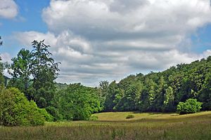
Low mountain range around Oelsen
|
Low mountain range around Oelsen
|
||
|
Nature reserve low mountain range around Oelsen (June 2014) |
||
| location | Saxony , Germany | |
| surface | 5.15 km² | |
| Identifier | D 50 | |
| WDPA ID | 164924 | |
| Geographical location | 50 ° 48 ' N , 13 ° 56' E | |
|
|
||
| Setup date | 2011 | |
The low mountain range nature reserve around Oelsen is located in the area of the town of Bad Gottleuba-Berggießhübel in the Saxon Switzerland-Eastern Ore Mountains district in Saxony .
The nature reserve, which consists of nine sub-areas, extends west of Breitenau and north, east, south and west of Oelsen , both districts of Bad Gottleuba-Berggießhübel. West of the area extends the A 17 , the S 171 and east the north country road L 173. At the northwestern edge extends the 58-66 ha large gottleuba dam , through the western part surfaces flows Gottleuba , a left tributary of the same , at the southern and The state border with the Czech Republic runs along the south-eastern edge .
meaning
The 515 hectare area with the NSG no. D 50 was placed under nature protection in 1990.


