
Bad Gottleuba-Berggießhübel
| coat of arms | Germany map | |
|---|---|---|

|
Coordinates: 50 ° 51 ' N , 13 ° 57' E |
|
| Basic data | ||
| State : | Saxony | |
| County : | Saxon Switzerland-Eastern Ore Mountains | |
| Management Community : | Bad Gottleuba-Berggießhübel | |
| Height : | 334 m above sea level NHN | |
| Area : | 88.72 km 2 | |
| Residents: | 5624 (Dec. 31, 2019) | |
| Population density : | 63 inhabitants per km 2 | |
| Postal code : | 01816 | |
| Primaries : | 035023, 035025, 035032, 035054 | |
| License plate : | PIR, DW, FTL, SEB | |
| Community key : | 14 6 28 020 | |
| City structure: | 12 districts | |
City administration address : |
Königstrasse 5 01816 Bad Gottleuba-Berggießhübel |
|
| Website : | ||
| Mayor : | Thomas Mutze ( Free Voters ) | |
| Location of the town of Bad Gottleuba-Berggießhübel in the Saxon Switzerland-Eastern Ore Mountains district | ||
  |
||

Bad Gottleuba-Berggießhübel is a town with around 5700 inhabitants in the Saxon district of Saxon Switzerland-Eastern Ore Mountains not far from Dresden . It was created in the course of the municipal reform of 1999 through the merger of the health resorts Bad Gottleuba (mud spa) and Berggießhübel (Kneipp health resort) as well as the municipalities of Langenhennersdorf and Bahratal. The town has been the seat of the Bad Gottleuba-Berggießhübel administrative association since January 2000 .
geography
Geographical location
The almost 90 square kilometers large municipal area of Bad Gottleuba-Berggießhübel is located about 45 kilometers southeast of the center of the Saxon capital Dresden . It includes large parts of the central Gottleubatal and parts of the catchment areas of Bahra , Seidewitz and Bahre . The city is located in the Elbe Valley Slate Mountains , a transition zone between the northeastern foothills of the Eastern Ore Mountains and the southwestern foothills of the Elbe Sandstone Mountains . The central part around the towns of Bad Gottleuba and Berggießhübel on the Gottleuba rivers have altitudes between 300 and 450 m above sea level. NN on. The lowest point of the community is in the Gottleubatal at 211 m above sea level. NN , the highest is 644 m above sea level. NN the Oelsener Höhe , located on the border with the Czech Republic .
geology
The location of the city in the transition area between the Eastern Ore Mountains and the Elbe Sandstone Mountains and in the area of the Central Saxon Disturbance suggests a complicated structure of the bedrock. In the south-western part, up to a line north of Hartmannsbach and Hellendorf, there is the "Freiberg gray gneiss ", the character rock of the Eastern Ore Mountains . Because of the Elbe River Valley Schiefergebirges closes up to a line north of Berggiesshuebel and Bahra the narrow strip with its Paleozoic (kambroordovizischen) rock groups, including a turmalinführender granite (from the Tremadocian ) grünschieferfazielle phyllite (from the Tremadocian partially mylonitisiert ), quartzites , conglomerates , Marbles and limestones . At the immediate transition to the Erzgebirge Gneiss, the granite is shaped in the form of a resistant chain of Härtlingsberg mountains (including Hüttenleite, Tannenbusch, Helleberg). Between Berggießhübel, Markersbach and Bahra, the penetration of granite into the limestones of the metamorphic zone of the Paleozoic Era caused the Berggießhübel magnetic iron ore deposits to arise . North of Berggießhübel and east of the Bahra, the rocks of the Elbe Valley Slate Mountains come into contact with the sandstone cover of the Elbe Valley Cretaceous Zone .
Community structure
Bad Gottleuba-Berggießhübel extends in the south from the Czech border and the district of Oelsen over the southeastern villages of Markersbach and Hellendorf, the southwestern Hartmannsbach, Breitenau, Börnersdorf and Hennersbach to Bad Gottleuba and Berggießhübel in the center and Zwiesel, Bahra and Langenhennersdorf in the north .
(in brackets: area code)
|
|
|
history

The settlement of the region has been practiced by the Bohemian kings since 1140. A major reason for this was the location on the trade routes that led, for example, from Halle (Saale) via Gottleuba to Aussig (Ústí nad Labem) ( Kulmer Steig , Königsweg, Salzstraße ).
On behalf of the ruling Bohemian dukes and kings, the development of the region was largely shaped by aristocratic families on Liebstadt , Weesenstein , Dohna and Pirna . They used locators who in turn recruited settlers and organized the settlement of the region. The names of these locators are still reflected today in the names of the villages in the region. The villages are all row villages with forest hooves . The settlers came from Thuringia , Hesse and Franconia , in the upper Eastern Ore Mountains there were also colonists of German origin from northern Bohemia.
A second period of settlement began in the region around 1240. Colonization was promoted by King Wenceslaus of Bohemia (1230–1253) primarily because of the ore discoveries in the Ore Mountains . In 1241 German farmers from the Egerland found tin crystals under the Mückenberg (near today's Zinnwald-Georgenfeld ) . The find was of such importance that the price of tin on the world market fell by half.
Later in the Middle Ages the affiliation of the places changed several times between the Bohemian Kingdom and the Mark of Meissen .
Oils
In 1429 the Hussites moved through the regions and destroyed oil. It was only rebuilt at the end of the 15th century. In the intervening period, only the " desert village " was mentioned .
.jpg)
.JPG)
.jpg)


The first written mention concerns Oelsen. As early as 1169, the appropriation of a forest near this village (silva iuxta Olesnice) from Duke Przemysl Vladislav II (1158–1173) to the Johanniter was notarized. The originally Czech name means "alder bush" (Czech: olešná). The founding of Oelsen is considered to be one of the oldest colonizing activities of the Johanniter in the eastern Ore Mountains.
In 1459 the demarcation between Bohemia and Saxony was re-regulated by a treaty between the Bohemian king and the Saxon rulers, Elector Friedrich and Duke Wilhelm ( Treaty of Eger ). With this, for example, Lauenstein , Königstein , Dippoldiswalde and also Gottleuba and Oelsen came to Saxony. This borderline is still essentially valid today.
In 1517, the von Bünau knight family , a widely branched knight family, for example on Liebstadt or Weesenstein, acquired the manor and village of Oelsen. Thus Oelsen belonged to the Lauenstein lordship .
The church in Oelsen, first mentioned in a document from the Archdiocese of Prague in 1358 , was furnished with valuable sandstone reliefs by Lorenz Hornung around 1620 .
After 245 years of ownership, the Bünaus sold Oelsen to bourgeois owners in 1762. In the sixth coalition war in 1813, Oelsen was embroiled in the bitter fighting between the Russians and the French. There was considerable damage; Ten farms were ruined, three burned down completely, the fields could not be tilled, the population suffered from hunger and disease.
In 1921, Oelsen began supplying electricity.
At the end of the Second World War , around 150 concentration camp prisoners were housed in Oelsen because of the evacuation of the large concentration camps . After the war, many expellees from the Sudetenland and Silesia came to Oelsen . The population therefore rose in 1945 to almost double the pre-war number.
In the years that followed, the town's infrastructure was gradually improved: bus connections from 1956, road construction in 1965/66 as part of the construction of the Gottleuba dam .
On January 1, 1996, Oelsen was incorporated into the city of Bad Gottleuba.
Population development in Oelsen
|
|
Oelsengrund
The demolition of the houses took place in connection with the construction of the dam, as they were in its catchment area.
Little love
Kleinliebenau was a district right on the border, it was demolished as a water catchment area as part of the dam construction.
Markersbach and Hellendorf (Bahratal)
The founding of the forest hoof village Markersbach (Marquardi villa) could also go back to the Johanniter, but is not clearly documented. The name was first mentioned in a document in 1363 and probably comes from a ruling dynasty ( Markwart (inger) or Marquart) who had made a special contribution to the introduction of German culture in Bohemia. The Waldhufendorf Hellendorf (Heldisdorf) was first mentioned in 1379. Both places are of Bohemian origin and are located in the Bahra Valley .
In the Middle Ages, the Kleppisch and Cratza hammer mills were located here, processing the iron ore extracted from Berggießhübel.
The small village church of Markersbach has a culturally and historically valuable mechanical slider chest organ by Christian Gottfried and Wilhelm Leberecht Herbrig from 1842.
Like Oelsen, the residents of both places suffered hardship and misery, destruction and looting during the Napoleonic War of 1813. Both places received a school in the 19th century (1837 and 1858). In 1927 the new school in Markersbach was inaugurated.
The Buschbach and Mordgrundbach retention basins built in the 1960s serve to prevent floods such as those that occurred here in 1897 and 1958.
On January 1, 1970, both places were merged to form the municipality of Bahratal (not to be confused with the directly neighboring municipality of Bahretal). In 1976 the border crossing to Petrovice (Peterswald) was reopened.
In the Saxon municipal area reform of January 1, 1999, Bahratal was incorporated into the city of Bad Gottleuba-Berggießhübel.

View of Markersbach

Memorial stone to the 1936 Olympic torch at the Bahratal border crossing

Herbrig organ in Markersbach
_2006-08-24.jpg)
_2006-03-24-2.jpg)

|
Population development in Markersbach
|
Population development in Hellendorf
|
Hartmannsbach

Hartmannsbach is not part of Bad Gottleuba-Berggießhübel in terms of the political structure of the community. It belongs to Bad Gottleuba, but historically it can be viewed separately.
The place is a row village (Waldhufen-Flur) and is located southwest of Gottleuba. The place was first mentioned as Hartmanspach in 1412. The name varied only slightly over the next few centuries: Hartmansbach, Harttenßbach, Hartenspach, Hartzbach, Harczbach, Hartzschbach, Hartmanstorff. The place consisted of Oberhartmannsdorf and Niederhartmannsdorf, the Ehrlich and Fischermühle and the Hammergut Haselberg.
The owners included well-known names in the region, such as Nickel Karras , von Torgaw, von Czickow, von Bernstein, von Bünau , von Mecsch or Metzsch . The place should initially have belonged to the Burgraviate of Dohna, later, after the defeat of the Donins in the Dohna feud, to the Margraviate of Meißen ("Dreßdenische pflege", "pflege zcu Donyn", "pflege zcu Pirne"). According to its owners, Hartmannsbach was partly included in the manors Giesenstein, Borthen and Röhrsdorf , Ottendorf Castle, Liebstadt and Weesenstein and finally also to the town of Gottleuba.
The jurisdiction has been demonstrable since 1485. According to a regulation from the year 1511, the beer of the Kretscham was obtained from Bärenstein and Altenberg.
Hartmannsbach is first parish to Ottendorf (evidently 1548). In 1576, however, the place already belonged to Gottleuba. This emerges from complaints from Haubold von Bernstein in Ottendorf, the Ottendorf pastor and the parishioners.
In 1840 Hartmannsbach consisted of 23 farm estates , a hereditary dish , two grinding and cutting mills (Fischer and Ehrlichmühle), seven garden foods and a few other houses . In the lower jurisdiction with services and taxes, it is subordinate to the heir, feudal lord and court lord of the Giesenstein manor, chamberlain of Globig.
The Hammergut Haselberg is also part of Hartmannsbacher Flur.
On January 1, 1936, the Hartmannsbach community was incorporated into the town of Gottleuba.
Hartmannsbach population development
|
|
Hennersbach

_2006-06-21.jpg)
Hennersbach is located about 7 kilometers southwest of Gottleuba in a small western bank of the Seidewitz . Starting from the Hennersbacher Mühle located on the Seidewitz (450 meters above sea level), the courtyards of the short row village extend to a height of about 500 meters above sea level.
The history of the small village goes back to the 14th century. It was first mentioned in a document as "Heinrichspach" in 1403. Other forms of name have been passed down as "Heynerspach" (1501) and "Haynerspach" (1516). The small, only 2.4 km², block-like forest hoof corridor is wedged between the significantly larger corridors of the neighboring villages of Breitenau, Börnersdorf, Döbra and Waltersdorf. This indicates that Hennersbach is a post-establishment. The small size of the corridor prevented a significant growth of the village, which in 1551 had only twelve possessed men and 14 residents (approx. 70 inhabitants). The population remained largely constant for centuries. In 1764 there were ten possessed men and four cottagers , in 1871 there were 137 inhabitants, in 1925 there were 116 inhabitants. The village currently has around 50 residents.
The economic basis of the place was agriculture for centuries. The Hennersbacher Mühle, built in 1605 as a grinding and grist mill, was shut down in 1948. Due to its small size, there was neither a school nor a church in Hennersbach. The Hennersbach children attended school in Liebstadt until a school was established in the nearby Börnersdorf in the 17th century. In terms of church, Hennersbach was tied to Liebstadt as well as to Döbra and Börnersdorf. Lauenstein and Liebstadt acted as market places for Hennersbach .
Hennersbach was lordly bound to the Lauenstein manor, which was under the von Bünau family from the 16th century to 1823 . On the administrative side, Hennersbach belonged to the Pirna office. With the end of patrimonial jurisdiction , the place was subordinated to the Lauenstein court office in the middle of the 19th century, and later to the Dippoldiswalde district administration. On November 1, 1934, Hennersbach was incorporated into Börnersdorf, which in turn came from the Dippoldiswalde district to the Pirna district in 1952 . Hennersbach has belonged to Bad Gottleuba since January 1st, 1997.
Bad Gottleuba

_Oberreit_1821.jpg)
.JPG)
_2006-07-24.jpg)
_2006-07-24.jpg)
_Postdistanzs%C3%A4ule.jpg)
The former mountain town of Gottleuba, located on the river of the same name, was first mentioned in 1363 as Gotlavia . The name changed several times over the years, including Gothlewen (1374), Gotleeb (1378), Gotelobe (1386), Goteleybe (1405) and Gottlewbe (1453).
However, there are indications that the place is much older than it was first mentioned. This is how the parish (church) located here was named as early as 1352. Parts of the tower of the church, which was probably originally used as a fortification, as well as the imperial eagle used in the city arms indicate that the place was founded before 1294. At that time the region around Gottleuba was administered as an imperial fief by the Burgraves of Dohna . Karlheinz Blaschke gives Gottleuba a population of 250 around 1300, which already indicates a well-developed community, which was probably founded by the Donins . This is also indicated by the sale of the place to King Wenceslaus of Bohemia in 1298 together with Pirna , since the sold areas were taken back in 1405 by the Meissen margrave of Jan von Wartenberg auf Tetschen as a pledge.
The construction of the settlement is to be seen in connection with a fortification that was built in the area of the church and cemetery. Below this area was a ford through the Gottleuba, which the Kulmer Steig used to cross the river on its route across the Eastern Ore Mountains to Bohemia.
Another fortification was located near the village of Erdmannsdorf, southeast of Bad Gottleuba. This village was first mentioned as Ertmansdorf in 1379 , but as early as 1206 noble court witnesses were mentioned as Lords de Ertmaresdorf . In 1379 the village came into the possession of Thimo von Colditz auf Graupen (today Krupka). Today the place no longer exists, as it was completely lost in the Hussite War in 1429 and most of its arable land fell to Gottleuba. To Erdmannsdorf included a castle, of which today only the name of the mountain Wachstein ( 524 m above sea level. NN ) or the popularly called Desolate castle testifies named rocky wilderness. The name of the stream Ratzschbach (Czech: hradschin = castle) south of the Wachstein is reminiscent of the earlier castle complex, of which the remains of the wall could still be seen in the middle of the 19th century. These fortifications served as a Meissen counterpart to the Bohemian fortifications (manor) in Oelsen. Both systems were necessary as quarters for the carters and animals of the merchant wagons that moved from Pirna and Dohna via Erdmannsdorf and Oelsen into Bohemia.
The decisive factor for the establishment of the settlement was not the carters, but ore finds made in the area. The mining background of the village is undisputed, as Gottleuba was a city without arable land. She received arable land only after she acquired the fields of the aforementioned Erdmannsdorf in the 15th century. Gottleuba's floor plan, with its irregular structure, also points to a rapidly developing settlement whose economic base lay in mining and not in agriculture or trade.
Iron-containing rock as well as some copper and silver were found at the northern end of the Erdmannsdorfer Flur. These finds attracted miners from Freiberg and Ehrenfriedersdorf but also from northern Thuringia and the Harz Mountains . As early as 1386 a sovereign bailiff regulated the mining conditions. The last mine (mining of silver ore) was not closed until 1889.
Gottleuba received town charter in 1463, but was mentioned as the steady Goteloybe as early as 1405 . Shortly before (1459) Gottleuba was added to the Mark Meissen in the aforementioned Bohemian border drawing contract.
The privileged location on the trade routes to Bohemia also promoted handicrafts and trade in Gottleuba. As early as the 16th century, Gottleuba guilds were given special trading rights (for example holding spring and autumn markets, approval of weekly markets ).
Wars, diseases, major city fires (1746 and 1865) and the flood disasters of 1552, 1897, 1927 and 1957 repeatedly brought major setbacks to the city.
The spa and bathing activities began in Gottleuba in 1881 (the first spa guests came as early as 1861). The basis for this was the existing moorland and the use of an iron spring. The first healing spring became known in 1828. 1909–1913 the State Insurance Institution of Saxony built a sanatorium , which gave Gottleuba the reputation of a Saxon bathing town. The sanatorium was designed as a now rare architectural monument in a uniform Art Nouveau style by the architects Schilling & Graebner . Gottleuba received state recognition and thus the right to use the name Bad in its name on December 20, 1936 on the basis of Section 9 of the German municipal code of January 30, 1935. On January 1, 1978, Bad Gottleuba became a state-approved health resort . Between 1954 and 1989, around 5000 cures were carried out annually in the clinic sanatorium. Since 1991 the sanatorium has been run by the TRIA Immobilienanlagen- und Verwaltungs-GmbH Berlin under the name of Gesundheitspark Bad Gottleuba .
From 1965 to 1974, the flood protection in the Gottleuba valley that had been required since the beginning of the century was finally implemented by building the dam . The dam is 52 m high and 327 m long, the water surface covers 174 hectares. The dam passed its practical test during the flood of the century in 2002. Nevertheless, damage amounting to 6 million euros occurred in the urban area.
With the completion of the Gottleuba dam in 1976, the almost 71-year long railway era in Gottleuba ended. The extension of the branch line Pirna – Berggießhübel to Gottleuba, which was once opened in 1905, impressed with its romantic route along the Gottleuba.
On January 1, 1999, the towns of Bad Gottleuba and Berggießhübel merged with the communities of Langenhennersdorf and Bahratal to form the new town of Bad Gottleuba-Berggießhübel.
Population development in Bad Gottleuba
|
|
|
Berggießhübel


_Schlo%C3%9F_Friedrichsthal.jpg)
Berggießhübel was first mentioned in 1457 as "Gißhobel, das dorff". A mention of the name "Gißhobel" seven years earlier (1450) in a statement by the bailiff of Pirna probably referred to the Gottleubaer Vogteibergwerk on the Witeberg and referred to the mine corridor. The existence of a settlement on this corridor can be assumed at this point in time, but there is no documentary evidence of this.
There are two explanations for the name: In Hey (The Slavic settlements in the Kingdom of Saxony - 1893) it says: “hubil” means something like elevation or hill; The Old High German “giozo”, Middle High German “gieze” or South German “Gieß, Gießen” means something like water pouring or waterfall and therefore does not come from old foundry huts. This could mean under Gießübel or Gießhübel a casting stone protruding into the air or a water channel. Schmidt, on the other hand, is in the Saxon Homeland Security Association. Volume XVI. 1927 believes that the name means "mountain where ore is melted and poured". It is an assumption that the name already existed in Berggießhübel before mining began. The corridor of the later Berggießhübel was owned by the Bergvogtei Gottleuba, Berggießhübel may not have existed before 1379. It was not until 1457 that it was called “Gißhobel das dorff”, in 1542 there was talk of “stetslein”, and finally in 1548 “stedtlein Bergk Gießhobel”. In this year the city charter was also awarded. Berggießhübel did not become independent in church until 1676.

In the Thirty Years War in 1648 the iron mines and hammer mills came to an almost complete standstill.
In 1717 medicinal water was found while driving a tunnel. The spring (Johann-Georg-Brunnen) founded the Berggießhübler bathing establishment. Five years later, a second source ("Friedrich or Sauerquelle") was discovered. A new bathhouse was built and the town was granted drinking, brewing and hunting rights.
In 1813 French troops occupied the place and caused great damage. The bathing business came to a standstill. In 1822, the bathing business was revived by Friedrich August Freiherr von Leyßer . With the commissioning of the railway line from Pirna via Langenhennersdorf to Berggießhübel on July 17, 1880, the region was further developed. In 1905 the railway continued to Gottleuba.
Since Berggießhübel is located in the very narrow Gottleubatal, it has always been badly affected by the floods of the river. However, the flooding of 1927 was a disaster for the place. On the night of July 8th to 9th, 1927, a huge tidal wave poured over the Gottleuba and neighboring Müglitz valleys. Around 130 people were killed in the Gottleubatal, including 88 in Berggießhübel alone.
Reconstruction has given the city its character since 1928. In 1934, the "Kneipp-Kurbad-Berggießhübel" was founded and the hydrotherapy method according to Pastor Sebastian Kneipp was introduced.
In 1942, the last shift was carried out on the Princess Höhe, shaft 381 of the Oberschlesische Hüttenwerke Gleiwitz, ending a more than 700 year old mining tradition.
After the war, the resumption of spa operations and expansion into the most important Kneipp spa in the GDR began in 1945 . In 1972 Berggießhübel became a state-approved Kneipp spa .
In 1993 the new MEDIAN clinic opened on the grounds of the "Friedrichsthal" estate.
In 1999 the two health resorts Berggießhübel and Bad Gottleuba merged with two other communities to form the town of Bad Gottleuba-Berggießhübel.
In 2006 the Marie-Louise-Stolln visitor mine was opened. The Berggießhübler Knappschaft was founded at Whitsun 2006.
Population development Berggießhübel
|
|
|
Langenhennersdorf and Bahra
_2007-01-26.jpg)
Langenhennersdorf was first mentioned in 1356 as "Hennici villa" and in 1404 was assigned to the Margraviate of Meißen . Half of the place was administered by the Kursächsisches Amt Pirna and the other half by the Cotta manor . Bahra was first mentioned in 1524. The name is derived from the Old High German “bar” (as much as empty) and “para” (as much as nakedness, forest nakedness, aborted forest) and thus means empty area, wasteland or forest nakedness.
Bahra was assigned to the manor Langenhennersdorf in 1548.
In 1649 an operating license for a smelting furnace for iron production was issued . In 1838 Bahra got its own school, while the first school for Langenhennersdorf was mentioned in a document in 1495.
On June 1, 1971, Bahra was incorporated into Langenhennersdorf. On January 1, 1999, as part of the municipal reform, Langenhennersdorf was finally incorporated into the town of Bad Gottleuba-Berggießhübel.
Börnersdorf and Breitenau

The small town of Börnersdorf ( Lage ) is the crash site of a transport plane that allegedly transported Hitler's private property. The Ju 352 went down, the cargo in iron boxes is still partially lost today. In 1983 the news magazine Stern claimed after research on the spot that it had acquired Hitler's diaries, which were in the boxes. But these expensive books soon turned out to be fakes . Not only the international press reported on the Hitler diary scandal. A well-known movie about the affair was made later , in which the crash in Börnersdorf is mentioned.
The municipalities of Börnersdorf and Breitenau (with Oelsengrund, which was incorporated on July 1, 1950) merged on January 1, 1972 to form the municipality of Börnersdorf-Breitenau. On January 1, 1997 Börnersdorf-Breitenau was incorporated into Bad Gottleuba.
Population and size development as a whole city
|
|
|
Overview of the incorporations
| Former parish | date | annotation |
|---|---|---|
| Bad Gottleuba | 01/01/1999 | |
| Bahra | 06/01/1971 | Incorporation to Langenhennersdorf |
| Bahratal | 01/01/1999 | |
| Berggießhübel | 01/01/1999 | |
| Bornersdorf | 01/01/1972 | Merger with Breitenau to form Börnersdorf-Breitenau |
| Börnersdorf-Breitenau | 01/01/1997 | Incorporation to Bad Gottleuba |
| Breitenau | 01/01/1972 | Merger with Börnersdorf to Börnersdorf-Breitenau |
| Hartmannsbach | 01/01/1936 | Incorporation to Gottleuba |
| Hellendorf | 01/01/1970 | Merger with Markersbach zu Bahratal |
| Hennersbach | 1934 | Incorporation to Börnersdorf |
| Langenhennersdorf | 01/01/1999 | |
| Markersbach | 01/01/1970 | Merger with Hellendorf zu Bahratal |
| Oils | 01/01/1996 | Incorporation to Bad Gottleuba |
| Oelsengrund | 07/01/1950 | Incorporation to Breitenau |
Memorials
Bad Gottleuba
- Memorial cross for the victims of the flood disaster of 8./9. July 1927 near the St. Petri Church.
- Cenotaph from 1951 in the Goethepark for the victims of fascism , including Richard Schäfer and Siegfried Rädel .
- Graves and memorial plaques in the Evangelical Cemetery on Hellersdorfer Straße for unknown concentration camp prisoners who were murdered by SS men on a death march from one of the subcamps in April 1945 . Also buried here Hungarian Jews from the central warehouse in Dresden-Reick of Flossenburg .
- Memorial plaque on Richard-Schäfer-Straße 33 residential building in the district in memory of the social democratic city councilor Richard Schäfer, who was murdered in Sachsenhausen concentration camp in 1945 .
Berggießhübel
- Memorial stone for the 88 victims of the flood disaster of 8./9. July 1927 on the spa promenade.
- Reminder and memorial stele for the victims of the Second World War on the spa promenade.
- Cenotaph from 1949 in front of the pharmacy for the victims of fascism
- Memorial plaque on the house at Talstrasse 1, on the street where Paul Linde was arrested on his way to work. The Nazi opponent Linde died in Sachsenhausen concentration camp in 1942 .
Oils
- Memorial stone and grave behind the church on the wall of the cemetery for six (or seven) shot or perished concentration camp inmates on a death march in April 1945 who were interned here and used to build anti-tank barriers .
politics
City council
The city council consists of 16 members.
- Since the local elections on May 25, 2014 , the CDU has had 11 seats, the Left Party 5 seats (+ 1). The free voters no longer had a seat.
- The proportion of votes in this election was 67.1% for the CDU, 29.2% for the Left and 3.7% for the FDP . The turnout was 52.6%.
- In the local elections in 2019, the CDU received 33.2% of the votes cast (6 seats in the council), the LFB 24.6% (4 seats), the AfD 20.7% (2 seats) and the Left 18.2 % of the vote (3 seats). A total of 4671 people were eligible to vote, of which 2948 cast their votes. The turnout was 63.1%.
coat of arms
|
|
Blazon : “The coat of arms is split into green and gold with a shield head in opposing colors. In front the coat of arms of Gottleuba in gold with a red armed black eagle and behind in silver a kneeling miner clad in black for Berggießhübel. In the head of the shield at the gap a fir tree in mixed up colors , on the right three green floating waves and on the left a golden ear . " |
| Justification of the coat of arms: The coat of arms of Berggießhübel was originally in gold with a kneeling tusk in black. |
Culture, education and sport
Attractions

Bad Gottleuba: Post mile column on the market
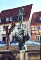
Bad Gottleuba: market fountain with figure "Young man with grapes" (1923)
Bad Gottleuba: health park

Berggießhübel: Friedrichsthal Castle

Berggießhübel: mouth of the "Marie Louise Stolln" visitor mine

Berggießhübel: "Marie-Luise-Stolln" mine

Altar of the church in Breitenau

Langenhennersdorf: Herbrig organ

_2006-03-24.jpg)
.jpg)
_2006-05-04.jpg)
_2006-08.jpg)
_2007-02-10.jpg)


.jpg)
_Traubenbrunnen_Markt.jpg)
Bad Gottleuba:
- Bähr-Mühle: Today the Bähr-Mühle is the only still functioning grain and sawmill in the Gottleubatal. Most of its technical equipment dates from the years 1898 to 1927.
- Evangelical Lutheran Church of St. Petri: The church, originally built as a fortified church, is the oldest surviving structure in the city. The substructure of the tower probably dates from the 13th century, the choir from the 15th century. and the nave is of late Gothic origin (1525). Worth seeing are the valuable ceiling frescoes, which presumably come from the school of Lucas Cranach , the late Gothic, richly structured branch portals and the net and ribbed vaults of the ship.
- Wells of health in the market
- Medianklinik: The Medianklinik is a Germany-wide unique sanatorium complex built between 1909 and 1913 by Schilling & Graebner with 34 Art Nouveau buildings in a 28 hectare park on the slope of the Helleberg. The former largest healing facility in Saxony now includes a rehabilitation center consisting of five specialist clinics and the medical-historical exhibition in the median clinic, which is well worth seeing. The German-Czech Education Center for Rehabilitation and Balneology is also located here.
- Saxon post mile column on the market from 1731, last renewed in 1980
- Plant garden
- Poetenweg Bad Gottleuba - Berggießhübel: The name of the hiking trail goes back to the bathers Gellert and Rabener who stayed here in the 18th century .
- town hall
- Municipal spa park Goethepark
- Gottleuba dam
- Augustusberg hiking area : From 507 m above sea level. NN high sandstone-covered Augustusberg opens up a wide view of the ridges of the Eastern Ore Mountains.
- Wachstein hiking area
Berggießhübel:
- Healing and visitor mine "Marie Louise Stolln": The healing and visitor mine opened in 2006 opens up the Friedrich-Erbstolln (later Marie Luise Stolln), which was used to mine iron ore between 1726 and 1926.
- Erich Mörbitz lookout point
- Evangelical Lutheran Church: The neo-Gothic building from 1876 replaced the church originally built in 1576, which burned down in 1874.
- Forellensteig Berggießhübel – Langenhennersdorf: The hiking trail leads along the Gottleuba to Langenhennersdorf.
- Haus des Gastes: Today's "Haus des Gastes" goes back to the "Johann-Georgen-Bad", built in 1722, the first bathhouse in the city.
- Flood memorial: A memorial in Badstrasse commemorates the victims of the flood disaster of 8/9 July 1927 .
_2007-09-21.JPG)
- Catholic St. Anthony's Church: The church was on July 10, 1993 consecrated and now belongs to the parish of St. Cunegonde in Pirna . Before that, a barrack built in 1928, which has since been demolished, was used as a Catholic church.
- Spa house "Johann-Georgen-Bad"
- Replica of the Saxon post mile column from 1727, destroyed by the floods in 1927, with a piece of coat of arms from Meißen in front of the former train station (original coat of arms in the Lauenstein Castle Eastern Ore Mountains Museum )
- Museum Heimatstube: The small museum provides information about the city's history
- Panorama height with Bismarck tower
- Prinzessinsäule Berggießhübel : The pillar on the road to Bahratal with its crescent sign at the top resembles a post mile pillar , but was erected around 270 years ago as a decorative pillar for the developing bathing industry.
- Palace park of Schloss "Friedrichsthal"
- Seismological observatory of the TU Bergakademie Freiberg with the measuring chamber in Hildebrand Stolln in Berggießhübel
- Atonement cross on Vierzehn-Nothelferweg
- Hochstein and Jagdstein hiking area
- Hiking area Zehistaer walls, rock bridges and Gersdorfer ruins
- Zwieseler Erbstollen (mouth hole): The 1400 m long Zwieseler Erbstollen, excavated in 1825 , was the main drainage system of the Berggießhübel iron ore mines.
- Zwieselmühle: The mill, already mentioned in 1516, was originally an iron hammer mill, from which a sawmill developed in the 17th century.
_2006-08-24.jpg)
Langenhennersdorf:
- Evangelical Lutheran Church: The hall church from the 15th century has a rich late baroque-classicist interior and a culturally and historically valuable mechanical slider-chute organ by Wilhelm Leberecht Herbrig from 1848, which was in the St. Katharinen Church in Helmsdorf ( OT von Stolpen).
- Langenhennersdorfer Wasserfall : Below the former Heringmühle, the hanging valley of the Langenhennersdorfer Bach flows into the Gottleuba in a 9 m high waterfall.
- Labyrinth hiking area near Langenhennersdorf
More Attractions:
- Mining historical hiking trail Berggießhübel – Bad Gottleuba – Schönwald (Krasny Les) - Graupen (Krupka)
- Retention basins Mordgrundbach and Bienhof in the Hellendorf district
- Churches in Markersbach (here: historical organ from the time 1842/43 by Christian Gottfried Herbrig and son); in Oelsen, Breitenau and Börnersdorf
- Saxon post mile pillars on the Old Dresden-Teplitzer Poststrasse in Börnersdorf (half mile pillar and quarter milestone) and Breitenau (full mile pillar, original in the church) and royal Saxon milestones on the new Dresden-Teplitzer Poststrasse (partly stored in the Dohma road maintenance depot )
Culture
One of the main cultural attractions is the annual carnival (since 1953 in Bad Gottleuba), which is carried out by the carnival clubs in Bad Gottleuba and Langenhennersdorf.
There are a number of other cultural events, such as the Poststrasse Festival in Bad Gottleuba, the Advent light festivals in Bad Gottleuba and in Berggießhübel, various shooting festivals organized by the Schützengesellschaft 1856 Berggießhübel e. V., Easter bonfires and maypole setting , local, local, club festivals in the individual districts, main street festival with white water races on the Gottleuba in Berggießhübel, the mill festival of the Bähr mill in Bad Gottleuba, hiking days and solstice celebrations of the volunteer fire brigade and the mountain club 1899 e. V. Berggießhübel as well as a large number of events organized by the health resort development and development association Bad Gottleuba-Berggießhübel e. V.
schools
The city maintains a primary school in Berggießhübel, the second primary school (Langenhennersdorf) was closed in 2005 due to the low number of new schooling. TRIA Immobilienanlagen- und Verwaltungsgesellschaft mbH Berlin leads a government-approved health Park private school as a hospital school . In addition, the Pirna Vocational School Center for Business in Langenhennersdorf maintains a branch office of the vocational school with a vocational special needs section.
In addition, there is the secondary school in Bad Gottleuba, which will be the only secondary or secondary school in the city of Bad Gottleuba from the 2006/2007 school year. The secondary schools in Rosental (2004) and Gersdorf (2006) were closed due to the continuing shortage of students and merged with the Gottleuba school.
Sports
Berggießhübel has an outdoor pool , the leisure and adventure pool "billy". There are also a number of sports clubs, some of which have their own sports facilities, and a skater track in Markersbach. The sports clubs in the city offer a wide variety of opportunities for sports, from football and volleyball to hiking and skating. The Schützengesellschaft 1856 Berggießhübel e. V. has its own shooting range "Am Jagdstein" (for large and small caliber).
science
Since 1957 the Institute for Geophysics of the TU Bergakademie Freiberg in Berggießhübel has been operating a seismological observatory in a disused ore mining gallery . Since 1974 the earthquake station with the identification BRG has been integrated into the worldwide network of seismological stations. More than 10,000 events are registered annually, including microquakes, mountain falls and explosions in the vicinity of up to 500 km. Earthquakes are registered on a global scale. The observatory can be visited after registration.
Economy and Transport
economy
_2005.jpg)
The city's economic focus is on spa and tourism . The spa system established itself in Berggießhübel at the beginning of the 18th century. In 1934 the city became the first official Kneipp spa in Saxony. Today the MEDIAN clinic , a rehabilitation clinic for orthopedics and psychosomatics, continues the spa tradition. The clinic, newly built in 1993, has almost 200 beds and currently employs around 110 people (as of December 2010). In Bad Gottleuba the spa and bathing system established itself at the end of the 19th century. Here, between 1909 and 1913, a spa complex, unique in Germany, was built on the slope of the Helleberg, consisting of 35 Art Nouveau buildings in a 28-hectare park. The Bad Gottleuba health park complex now includes 6 specialist clinics in which up to 650 patients can be cared for. Including the two health clinics, Bad Gottleuba-Berggießhübel had 1,208 guest beds in 2013. In the same year, the municipality recorded 24,459 arrivals and 255,522 overnight stays.
In Berggießhübel in particular, there are some medium-sized production companies that are mainly active in mechanical engineering, medical technology and plastics production. In 2013, the mining and manufacturing sector comprised four companies with 498 employees for the entire Bad Gottleuba-Berggießhübel community. The most important production companies are:
- Eloma GmbH in Berggießhübel (cooking and baking technology, 2012: approx. 200 employees)
- Bergi-Plast GmbH in Berggießhübel (plastics technology and mold making, 2013: approx. 100 employees)
- B. Braun Avitum Saxonia GmbH in Berggießhübel (medical technology, 2014: approx. 200 employees)
- MB Maschinenbau Berggießhübel GmbH in Berggießhübel (mechanical engineering)
There are also a number of retailers, craftsmen and service providers as well as two branches of the Ostsächsische Sparkasse Dresden (Bad Gottleuba, Berggießhübel) and one of the Volksbank Pirna (Berggießhübel). Agriculture is also important in the rural districts. It is operated in particular by the Agrarproduktivgenossenschaft eG Weideland in Oelsen and the Agrargenossenschaft Bielatal eG in Langenhennersdorf.
traffic
_2006-07-24.jpg)
The road-side development and regional connection of the city of Bad Gottleuba-Berggießhübel takes place via the federal motorway 17 (A 17) Dresden - Prague and various state roads . The A 17 Dresden - Prague crosses the western municipal area in the Börnersdorf - Breitenau area. The Bad Gottleuba junction on the S 176 is also located here.
The most important state roads are the S 173, which leads from Pirna via Cotta, Berggießhübel and Hellendorf to the border crossing point Bahratal- Petrovice (Peterswald), the S 174, which goes from Pirna through the Gottleubatal via Berggießhübel and Bad Gottleuba to the S 176 to Breitenau and further on Lauenstein leads as well as the S 176, which connects Pirna with Börnersdorf and Breitenau. In the course of the construction of the A 17, the S 176 was laid as a bypass road from Börnersdorf and Breitenau.
The Gottleubatalbahn operated to Bad Gottleuba until 1976 . The branch line was opened to Berggießhübel in 1880 and extended to Bad Gottleuba in 1905. 1973 the passenger traffic in the Gottleubatal was stopped. Construction material for the Gottleuba dam was still transported until 1976, when the line was dismantled. Today it can be used in sections as a hiking and cycling path while retaining historical railway signs.
The nearest airport is in Dresden-Klotzsche . Sports pilots can also use the Pirna glider airfield in the Pratzschwitz district .
The regional traffic is handled by the regional traffic Saxon Switzerland-Eastern Ore Mountains and the taxi, rental car and bus company Uwe Jurk. The main bus lines served in the municipality are:
- 214 Bad Gottleuba - Oelsen - Breitenau - Bad Gottleuba
- 216 Pirna - Langenhennersdorf - Berggießhübel - Gottleuba - Bahratal
- 218 Pirna - Langenhennersdorf - Bahra - Bahratal
- 219 Pirna - Cotta - Berggießhübel - Gottleuba - Bahratal
Several culturally and historically significant post mile columns remind of the formerly important traffic location on the old and new Dresden-Teplitzer Poststrasse . You are in Bad Gottleuba (distance column), Berggießhübel (distance column), Börnersdorf (half mile column and quarter milestone) and Breitenau (half mile column).
Personalities
- Johann Zacharias Grundig (1669–1720), Kreuzkantor from 1713 to 1720
- Johann Andreas Cramer (1710–1777), well-known metallurgist, spent the last years of his life in Berggießhübel
- Johann Gottlob Lehmann (1719–1767), studied medicine and later geologist, is considered a co-founder of stratigraphy, born in Langenhennersdorf
- August Friedrich Wilhelm Freiherr von Leyßer (1771–1842), Lieutenant General ret. D., Officer of the Legion of Honor, President of the Second Chamber of the Saxon Estates Assembly, Lord of the Castle at Friedrichsthal and Bad Owner
- Christian Friedrich Grimmer (1798–1850), composer and bookseller
- Heinrich Ferdinand Mannstein (1806–1872), singing teacher and writer
- Heinrich Lieber (1840–1916), anti-Semitic member of the Reichstag
- Camillo Schumann (1872–1946), Grand Ducal Saxon music director and court organist, composer and organist, honorary citizen of Bad Gottleuba
- Arthur Mittag (1906–1946), psychiatrist who was involved in euthanasia crimes as part of child euthanasia during the Nazi era
- Fritz Rößler (1912–1987), NSDAP trainer and under the name of Dr. Franz Richter Member of the Bundestag
- Wolfgang Ullmann (1929-2004), German theologian, church historian and politician (Bündnis 90 / Die Grünen)
- Dragan Holcer (1945-2015), Yugoslav football player
- Udo Stimpel (* 1956), soccer player
Famous bathers:
- Christian Fürchtegott Gellert (1715–1769), fable poet
- Gottlieb Wilhelm Rabener (1714–1771), satirist
Wars, floods and other disasters
- Thirty Years War : During the course of the war, the towns and villages in and around the Gottleubatal were repeatedly badly affected by marauding and pillaging troops. The hitherto flourishing iron ore mining came to a standstill as a result of the war, the Hammergüter, like the Kammerhof in Markersbach (1632), was largely destroyed. In 1697, 12 houses in Berggießhübel and 45 in Gottleuba were uninhabited due to the war.
- February 19, 1746: A city fire destroyed 18 houses and 11 barns in Gottleuba.
- October 4, 1865: The center of Gottleuba was almost completely destroyed by a city fire. A total of 100 main and auxiliary buildings fell victim to the flames, only 66 houses and the church remained undamaged.
_2006-07-24.JPG)
- 8/9 July 1927 : One of the most devastating flood disasters in recent German history occurred in the Gottleubatal. A meter high tidal wave destroyed numerous houses and traffic routes, the center of Berggießhübel was almost completely devastated. Around 130 people fell victim to the floods in the entire Gottleubatal, including 88 in Berggießhübel and 15 in Gottleuba, Hartmannsbach and Oelsengrund.
- May 8, 1945: Several buildings were destroyed in an air raid by the Red Army , including the Luther House in front of the church, a house on the market square and a house on the lower main street (then Adolf-Hitler-Strasse). Several residents and soldiers passing through were killed by bombs and gunfire. The soldiers belonged to units of Army Group Center under the command of General Field Marshal Ferdinand Schörner , who wanted to go into American captivity via Bohemia. It is believed that the Soviet Army wanted to meet the Field Marshal General, as he had probably taken up quarters in Bad Gottleuba.
- 12./13. August 2002 : The flood of the century in the summer of 2002 caused no damage comparable to that of 1927 thanks to the flood protection facilities built since the 1950s. The flood damage in the entire city area amounted to 6 million euros.
literature
- About Bad Gottleuba, Berggiesshübel and Liebstadt (= values of the German homeland . Volume 4). 1st edition. Akademie Verlag, Berlin 1961.
- Eastern Ore Mountains (= values of the German homeland . Volume 10). 1st edition. Akademie Verlag, Berlin 1966, pp. 244-257.
- Boris Böhm: 100 years of the Bad Gottleuba health resort. In: Sächsische Heimatblätter . 59 (2013) 4, pp. 380-383.
- Moritz Fischer: Guide through the Gottleubathal . Axt, Dresden 1881. ( digitized version )
- Siegfried Fischer, Annemarie Fischer: History of the city of Bad Gottleuba-Berggießhübel in 11 parts. Dresden 2012. ( digitized version )
- Johann Friedrich Henckel : Giesshübelium Redivivum, The resurgent Berg-Gießhübel… Freiberg 1729. ( digitized version )
- Günter Groß , Rikarda Groß : Breitenau. A border village in the Eastern Ore Mountains. Dippoldiswalde 2014
- Günter Groß , Rikarda Groß: Hennersbach, Börnersdorf, Liebstadt - on the upper reaches of the Seidewitz in the Eastern Ore Mountains. Dippoldiswalde 2017
- Emil Kaulitzsch: Administrative report of the city of Gottleuba for the years 1885 to 1889. At the same time a contribution to the local history of the city of Gottleuba and its surroundings . Leipzig 1890. ( digitized version )
- Bad Gottleuba spa administration (ed.): Gottleubaer Wanderfreund. Bad Gottleuba 1992, 2000.
- Rudolf Landgraf: Berggießhübel hiking guide. A home book. Roßwein 1938.
- Alfred Meiche: Historical-topographical description of the Pirna administration. Dresden 1927. ( digitized version )
- Katja Margarethe Mieth (Ed.): Excellent healing successes: Workers' sanatorium - clinic sanatorium - health park. 100 years of spa time in Bad Gottleuba. Verlag der Kunst, Husum 2014, ISBN 978-3-86530-205-2 .
- Markus Wollmann: Berggießhübel - Bad Gottleuba. (= Brockhaus-Wanderheft. Volume 18). FA Brockhaus, Leipzig 1989.
Web links
- Official web presence of the city administration Bad Gottleuba-Berggießhübel
- Bad Gottleuba-Berggießhübel in the Digital Historical Directory of Saxony
- Kurgesellschaft Bad Gottleuba-Berggießhübel mbH
to Bad Gottleuba:
- Bad Gottleuba health park and other information on the development of the spa system
- Medical history exhibition in the Bad Gottleuba health park
to Berggießhübel:
- Private homepage about Berggießhübel including information on the town's history, spa facilities, mining history and transport
- Visitor mine "Marie-Louise-Stolln" Berggießhübel, among other things, information on the mining history
Individual evidence
- ↑ Population of the Free State of Saxony by municipalities on December 31, 2019 ( help on this ).
- ^ StBA: Changes in the municipalities in Germany, see 1996
- ↑ Herbrig organs. In: www.herbrig-orgeln.de. Retrieved January 13, 2017 .
- ↑ a b c municipalities 1994 and their changes since 01.01.1948 in the new federal states , Metzler-Poeschel publishing house, Stuttgart, 1995, ISBN 3-8246-0321-7 , publisher: Federal Statistical Office
- ↑ a b c d StBA: Changes in the municipalities of Germany, see 1999
- ^ Territorial changes in Germany and German administered areas 1874–1945
- ↑ Incorporation to Gottleuba
- ↑ a b Bad Gottleuba-Berggießhübel in the Digital Historical Directory of Saxony
- ↑ Hennersbach. In: badgottleuba-berggiesshuebel.de. Kurgesellschaft Bad Gottleuba-Berggießhübel, accessed on February 19, 2016 .
- ↑ Lauenstein mansion in the main state archive in Dresden ( page no longer available , search in web archives ) Info: The link was automatically marked as defective. Please check the link according to the instructions and then remove this notice.
- ^ Michael Rademacher: German administrative history from the unification of the empire in 1871 to the reunification in 1990. Dippoldiswalde district. (Online material for the dissertation, Osnabrück 2006).
- ^ StBA: Changes in the municipalities in Germany, see 1997
- ^ Karlheinz Blaschke: The urban system from the 12th to the 19th century. Supplement to map B II 6 of the Atlas of the History and Regional Studies of Saxony, ed. from the Saxon Academy of Sciences and the State Surveying Office of Saxony. Leipzig / Dresden 2003.
- ↑ a b Blaschke 2003, estimated from house numbers from the 16th century
- ↑ a b c Blaschke 2003, calculated from tax lists
- ↑ Number of houses from 1837.
- ↑ a b residents over 10 years
- ↑ a b Number of houses from 1816.
- ^ StBA: Changes in the municipalities, see 1997
- ^ According to Blaschke 2003, German Academy of Sciences in Berlin 1961, Schiffner 1840 and information from the State Statistical Office of Saxony, from 1991: status as of December 31. of the respective year
- ↑ Blaschke 2003, number of houses from 1837.
- ↑ As of October 3, 1990.
- ↑ 2014 municipal council elections - preliminary result , accessed on August 7, 2014.
- ↑ https://wahlen.sachsen.de/Erresult_GR19.php?landkreis=14628&gemeinde=14628020&_ptabs=%7B%22%23tab-stimmengabe%22%3A1%7D
- ↑ Eckart Roloff and Karin Henke-Wendt: From sanatoriums to military hospitals to modern rehab. (The medical history exhibition in the health park) In: Visit your doctor or pharmacist. A tour through Germany's museums for medicine and pharmacy. Volume 1, Northern Germany. Verlag S. Hirzel, Stuttgart 2015, pp. 174-176, ISBN 978-3-7776-2510-2
- ↑ http://www.kath-kirche-pirna.de/ St.-Antonius-Kirche on the Internet presence of the parish of Pirna, accessed on August 3, 2018
- ↑ Internet presence of MEDIAN Klinik Berggießhübel ( memento of the original from December 10, 2011 in the Internet Archive ) Info: The archive link has been inserted automatically and has not yet been checked. Please check the original and archive link according to the instructions and then remove this notice.
- ↑ The Berggießhübler Clinic wants more patients again. In: Saxon newspaper. (Pirna edition), December 23, 2011.
- ↑ Internet presence of the Bad Gottleuba Health Park
- ↑ a b State Statistical Office Saxony - Municipal Statistics Bad Gottleuba-Berggießhübel 2014
- ↑ Berggießhübel company turns up. In: Saxon newspaper. (Pirna edition), June 21, 2012.
- ↑ Bergi-Plast presents its new location. In: Saxon newspaper. (Pirna edition), April 6, 2013.
- ↑ It's getting tight on Ladenberg. In: Saxon newspaper. (Pirna edition), November 15, 2014.
Altenberg | Bad Gottleuba-Berggießhübel | Bad Schandau | Bahretal | Bannewitz | Dippoldiswalde | Dohma | Dohna | Village grove | Dürrröhrsdorf-Dittersbach | Freital | Glassworks | Gohrisch | Hartmannsdorf-Reichenau | Heidenau | Hermsdorf / Erzgeb. | Hohnstein | Klingenberg | Königstein (Saxon Switzerland) | Kreischa | Liebstadt | Wages | Müglitztal | Neustadt in Saxony | Pirna | Rabenau | Rathen | Rathmannsdorf | Reinhardtsdorf-Schöna | Rosenthal-Bielatal | Sebnitz | City of Wehlen | Stumble | Struppen | Tharandt | Wilsdruff