
Ehrenfriedersdorf
| coat of arms | Germany map | |
|---|---|---|

|
Coordinates: 50 ° 39 ' N , 12 ° 58' E |
|
| Basic data | ||
| State : | Saxony | |
| County : | Erzgebirgskreis | |
| Height : | 530 m above sea level NHN | |
| Area : | 15.89 km 2 | |
| Residents: | 4680 (Dec. 31, 2019) | |
| Population density : | 295 inhabitants per km 2 | |
| Postal code : | 09427 | |
| Area code : | 037341 | |
| License plate : | ERZ, ANA, ASZ, AU, MAB, MEK, STL, SZB, ZP | |
| Community key : | 14 5 21 160 | |
| LOCODE : | DE ZEF | |
City administration address : |
Markt 1 09427 Ehrenfriedersdorf |
|
| Website : | ||
| Mayoress : | Silke Franzl | |
| Location of the town of Ehrenfriedersdorf in the Erzgebirge district | ||
  |
||

Ehrenfriedersdorf is a town in the Erzgebirge in Saxony (Germany). The Silberstraße runs through the city .
geography
Ehrenfriedersdorf is located on the upper course in the valley of the Wilisch river at an altitude of around 600 m. In the west are the heights of the Greifensteine and in the east the Sauberg and the Kalte Muff with the Franzenshöhe (703 m).

Neighboring communities
The following communities border Ehrenfriedersdorf (clockwise, starting in the north): Thum , Drebach , Thermalbad Wiesenbad , Tannenberg , Geyer and Zwönitz .
Gripping stones
The Greifensteine are a rock formation in the Ore Mountains in the forest area between the villages of Geyer, Ehrenfriedersdorf, Jahnsbach and Thum in the area of the town of Ehrenfriedersdorf. They reach a height of 732 m above sea level and are considered the highest point on Ehrenfriedersdorfer Flur. The rock group with the natural stage are known nationwide as a natural monument .
Franzenshöhe
The Franzenshöhe is one of the highest points in the city. It is located in a forest (the so-called Huuf-Buhsch ) and can therefore not be seen from various vantage points. The imposing rock formations on the summit are particularly striking.
history

Surname
The linguist Ernst Eichler and the name watchers Hans Walther keep the place for settlement of a Irminfried , the first syllable of the name have to be ren changed, later, the first syllable is as Honorary been interpreted. A name formation from the old high German era (honor) is not to be assumed.
Settlement and mining
Ehrenfriedersdorf, like the rest of the central Ore Mountains, was settled in the 12th century. In the 13th century there was an upswing due to the discovery of tin . In 1339 the settlement was first mentioned as Erinfritstorf . In the middle of the 15th century the place received full city rights and was considered one of the richest in the Ore Mountains.
He owned a savings bank and a district court.
Population development
On October 3rd, 1990 Ehrenfriedersdorf had 6,263 inhabitants. The following population figures refer to December 31 of the respective year:
|
1993 to 1997
|
1998 to 2002
|
2003 to 2007
|
from 2009 on
|
- Source up to 2006: State Statistical Office of the Free State of Saxony
- Source 2007: City of Ehrenfriedersdorf (as of May 31, 2007)

Memorials
- Memorial stone near the sports field in memory of six opponents of the Nazi regime who were murdered in prisons and concentration camps : Max Niklas , Kurt Leupold , Paul Weber , Max Neubert , Richard Bock and Milda Schreyer .
politics
City council
Since the municipal council election on May 26, 2019 , the 16 seats of the city council have been distributed among the individual groups as follows:
The mayoress is the chairman of the city council.
mayor
- 1988–1990: Rolf Neumann
- 1990–1994: Klaus Meinig ( CDU )
- 1994–2015: Frank Uhlig ( SPD )
- since 2015: Silke Franzl
coat of arms
Blazon : “Red-gold divided obliquely on the left; above a gold ring with a blue stone, below crossed blue mallets and iron . "
The city coat of arms shows the signet ring of the Waldenburg rule, to which Ehrenfriedersdorf once belonged. Hammer and mallet are the well-known symbols of the mining industry that shaped the city for centuries.
Town twinning
- Burgkunstadt in the Lichtenfels district, Bavaria
- Podbořany , Czech Republic
Sights, culture and regular events

St. Niklaskirche
The most precious work of art in the St. Niklaskirche is the late Gothic cabinet altar, which was erected here in 1507 and completed by 1512 and which can be changed (closed) twice. The prosperity of the city brought about by mining is visible in the fact that the church could afford to oblige the great master HW ( Hans Witten ) to design the altar. He used linden wood as a material. The altar is made of wood up to the very tip of the blast.
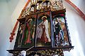
Everyday page

Sunday side

Holiday page


Museums
Is located on the Sauberg in the former tin mine the tin mine Ehrenfriedersdorf , a visitor mine with mineralogical museum. It shows how tin was mined industrially until 1990. The condition of the tunnels corresponds to the status at that time. The visitor mine and museum is part of the Saxon Industrial Museum .
The Ehrenfriedersdorf mining area is a selected site for the proposed candidacy for the UNESCO World Heritage Site of the Ore Mountains Mining Region .
music
In 1973 the Erzgebirgsgruppe Ehrenfriedersdorf was founded, an ensemble that has dedicated itself to cultivating the Erzgebirge dialect and is one of the most popular vocal formations in the region. Numerous radio and television appearances already made the group known nationwide during the GDR era. After the political change, tours to the USA followed .

theatre
At the beginning of the 1990s, the dialect theater at Greifenstein e. V. founded. This theater group took over the tradition of the Mettenspiel at the Mettenschicht , which until then was carried out by the members of the Bergbruderschaft in the buildings of the former Sauberg tin ore mine . The Ehrenfriedersdorfer Mettenschicht is distinguished not only by the memory of the unfortunate miners but also by the folk play, which is performed by the dialect theater.
Regular events
Since around 1991 there have been the annual festivities for moving the maypole and a witch's fire on April 30th on the ski slope at the chicken farm, and on May 1st there is an uphill run by the Ehrenfriedersdorf Association . At Christmas time, the pyramid pushing is celebrated by the residents and guests.
Economy and Infrastructure

From the middle of the 13th century until 1990, tin was mined in Ehrenfriedersdorf. After the German reunification, there was no longer any economic viability. In the following years the mine was rebuilt for visitors. An integrated and scientifically researched healing cave offers numerous therapies, including for respiratory diseases.
The federal road 95 runs through Ehrenfriedersdorf . Between 1906 and 1967/68 the place had a train station and a stop on the narrow-gauge railway Schönfeld-Wiesa-Meinersdorf .
Personalities
literature
- Richard Steche : Ehrenfriedersdorf. In: Descriptive representation of the older architectural and art monuments of the Kingdom of Saxony. 4th booklet: Official Authority Annaberg . CC Meinhold, Dresden 1885, p. 65.
Individual evidence
- ↑ Population of the Free State of Saxony by municipalities on December 31, 2019 ( help on this ).
- ^ Ernst Eichler and Hans Walther : Saxony. All city names and their history , Faber and Faber Verlag, Leipzig 2007, ISBN 978-3-86730-038-4 , p. 56
- ↑ Results of the 2019 municipal council elections
- ↑ Regio ticker events . In: Wochenspiegel of April 30, 2011, p. 2
Web links
- Ehrenfriedersdorf in the Digital Historical Directory of Saxony
- Official presence of the city administration

Amtsberg | Annaberg-Buchholz | Aue-Bad Schlema | Auerbach | Bear Stone | Bockau | Börnichen / Erzgeb. | Breitenbrunn / Erzgeb. | Burkhardtsdorf | Crottendorf | Deutschneudorf | Drebach | Ehrenfriedersdorf | Eibenstock | Parents | Gelenau / Erzgeb. | Geyer | Gornau / Erzgeb. | Gornsdorf | Großolbersdorf | Großrückerswalde | Grünhain-Beierfeld | Grünhainichen | Heidersdorf | Hohndorf | Jahnsdorf / Erzgeb. | Johanngeorgenstadt | Jöhstadt | Königswalde | Lauter-Bernsbach | Loessnitz | Lugau | Marienberg | Mildenau | Neukirchen / Erzgeb. | Niederdorf | Niederwürschnitz | Oberwiesenthal | Oelsnitz / Erzgeb. | Olbernhau | Pockau-Lengefeld | Raschau-Markersbach | Scheibenberg | Schlettau | Schneeberg | Schönheide | Schwarzenberg / Erzgeb. | Sehmatal | Seiffen / Erzgeb. | Stollberg / Erzgeb. | Column green | Tannenberg | Thalheim / Erzgeb. | Thermal bath Wiesenbad | Thum | Selva | Zschopau | Zschorlau | Zwönitz