
Moldava
| Moldava | |||||
|---|---|---|---|---|---|
|
|||||
| Basic data | |||||
| State : |
|
||||
| Region : | Ústecký kraj | ||||
| District : | Teplice | ||||
| Area : | 3242.3046 ha | ||||
| Geographic location : | 50 ° 43 ' N , 13 ° 39' E | ||||
| Height: | 725 m nm | ||||
| Residents : | 192 (Jan. 1, 2019) | ||||
| Postal code : | 417 81 | ||||
| License plate : | U | ||||
| structure | |||||
| Status: | local community | ||||
| Districts: | 2 | ||||
| administration | |||||
| Mayor : | Jaroslav Pok (as of 2013) | ||||
| Address: | Moldava 113 417 81 Moldava |
||||
| Municipality number: | 567728 | ||||
| Website : | www.moldava.cz | ||||
| Location of Moldava in the Teplice district | |||||

|
|||||


Moldava ( German Moldau ) is a municipality in Ústecký kraj in the Czech Republic .
geography
location
Moldava is located in the Eastern Ore Mountains about 25 km northwest of Teplice at 785 m nm In the southeast is the second highest mountain in the Eastern Ore Mountains, the Pramenáč , at 909 m, and the 869 m high Bouřňák in the south . The springs of Freiberg Mulde , Flöha and Wilder Weißeritz are located between Moldava and its district Nové Město . The closest Czech town is Mikulov v Krušných horách on the steep southern slope of the mountains. A border crossing that is closed to trucks leads to Neurehefeld , a district of the city of Altenberg in Saxony .
Community structure
The municipality of Moldava consists of the districts Moldava ( Moldau ) and Nové Město ( New Town also Newenstat or Nova Civitas ). Basic settlement units are Moldava, Nové Město, Oldřiš (Ullersdorf) and Pastviny (Grünwald) .
The municipality is divided into the cadastral districts of Moldava, Nové Město u Mikulova, Oldřiš u Moldavy and Pastviny u Moldavy.
Neighboring places
| Rechenberg bee mill | Hermsdorf / Erzgeb. | Altenberg |
| Osek (Ossegg) |
.svg)
|
Mikulov (Niklasberg) |
| Hrob (monastery tomb) |
history
The first written mention comes from the year 1346 as a glassmaking settlement with a church. During the Thirty Years' War the glassworks ceased to exist and the people devoted themselves to cattle breeding, forestry and fluorite mining. The old Freiberg-Teplitzer Poststrasse from the 18th century led over the Vltava and Neustadt down into the North Bohemian Basin . In 1884 the border station on the rail link from Brüx to Freiberg was built in Moldova . The Freiberg – Moldava line is closed from Holzhau, trains still run from Most . This line, formerly known as the Teplitz Semmering Railway , was built to transport lignite from the Brüx basin to Saxony. The predominantly German-Bohemian population until the end of the Second World War was expelled in 1946 . Today mainly Czechs live here, whose families moved here after the Germans were driven out of the interior.
Development of the population
|
|
|
Mining

In Moldava, silver , lead and copper were already being mined in the 15th century . The mining remained relatively insignificant compared to other mining locations in the Ore Mountains. An intensive exploration for lead and tin has been carried out in and around Moldava since the 19th century .
At the beginning of the 1950s, a minable fluorite and barite deposit was discovered in the valley of the Vltava stream , which was opened up from 1953. The subject of the dismantling was a corridor system about 6 kilometers long and 1 kilometer wide, in which the “Papousek” and “Josef” corridors in particular were up to 6 meters thick. The average fluorite content was 58% calcium fluoride . The largest fluorite crystal found here had an edge length of 29 centimeters. Overall, the Moldava deposit turned out to be the most important fluorite deposit in the Czech Republic.
The development took place through two main production shafts and several drainage tunnels. 8 levels were laid down to a depth of 480 meters. The ascended routes included a length of about 26 kilometers. The annual output rose rapidly and steadily from 249 tons (1957) to around 30,000 tons at the end of the 1980s.
The production was stopped in 1994 due to lack of profitability and the daytime facilities below the church were partially canceled. At that time, the total output from the Moldava deposit was approximately 690,000 tons of fluorite. The deposit has by no means been completely dismantled. The remaining quantities are around 1.5 million tons of fluorite.
gallery

Moldava Church (2012)
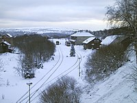
View of the Moldava train station (2006)
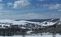
View to the west down the valley
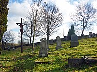
Old cemetery in Moldova


Individual evidence
- ↑ uir.cz
- ↑ Český statistický úřad - The population of the Czech municipalities as of January 1, 2019 (PDF; 7.4 MiB)
- ↑ uir.cz
- ↑ uir.cz
- ↑ uir.cz
- ↑ Historický lexikon obcí České republiky - 1869-2015. (PDF) Český statistický úřad, December 18, 2015, accessed on January 25, 2016 (Czech).
literature
- Jaroslav Hrabánek: The history of mining in the Bohemian Ore Mountains. In: Agricola Research Center Chemnitz. Newsletter. 2007, ISSN 1614-9505 , pp. 5-42, digitized version (PDF).
- Novotná Pokorná: A travel guide through the mining monuments of the Central and Eastern Ore Mountains. Discover cultural heritage. Ústí region, Ústí nad Labem 2013, ISBN 978-80-260-1831-5 , digitized version (PDF).
Web links
- Homepage (Czech, German, English)