Fojtovice
| Fojtovice | ||||
|---|---|---|---|---|
|
||||
| Basic data | ||||
| State : |
|
|||
| Region : | Ústecký kraj | |||
| District : | Teplice | |||
| Municipality : | Krupka | |||
| Area : | 480.9718 ha | |||
| Geographic location : | 50 ° 43 ' N , 13 ° 51' E | |||
| Height: | 720 m nm | |||
| Residents : | 95 (March 1, 2001) | |||
| Postal code : | 417 41 | |||
| License plate : | U | |||
Fojtovice (German Voitsdorf ) is a district of the city of Krupka in the Czech Republic .
Geographical location
Voitsdorf is a village in the north of the Czech Republic. It is 700 m nm high and borders on Fürstenau , Cínovec and Adolfov .
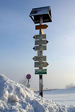
The excursion destination Komáří hůrka (Mückenberg), one of the highest mountains in the Bohemian Eastern Ore Mountains, belongs to Voitsdorf . The mosquito tower can be reached in about three kilometers from the parking lot in Fürstenau (at the customs house) via the hiking crossing. From the Zinnwald / Cínovec border crossing , it is about five kilometers along the border.
history
In the 13th century the place was founded by settlers from Bavaria and Franconia. In 1836 the Graupenbergstraße was built from Mückenberg via Voitsdorf to Müglitz and on to Dresden . From 1880 hat production established itself, since the tin mining was no longer worthwhile. Three hat factories were created, which merged as the United Straw and Felt Hat Factories . A cardboard box factory was also built. In 1883 a school was built in the village.
Construction of a church began in 1912, but was not completed until 1933. This Peter and Paul Church was blown up by the Czechs in 1958. In 1935 the volunteer fire brigade was equipped with an engine sprayer and the transformer house was connected with a high-voltage cable. In 1938 the bus routes to Teplice and Lauenstein were opened. Until then, the population had to walk to the nearest train stations in Mariaschein or Lauenstein.

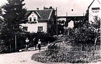
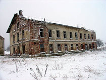
After the Second World War , most of the inhabitants - almost exclusively German Bohemia - were expelled on the basis of the Benesch decrees , and the uninhabited village was largely given up. Most of the houses were demolished, including almost all from the old town center, and the stones were transported to Slovakia as building material . A few houses have been preserved and, together with two newly built apartment blocks, serve as accommodation for some Roma who have moved inland .
Before the destruction of the place there were 136 houses in which 820 inhabitants lived, there was a post office with a telephone connection to Teplice, a bank and a mayor's office. There were also 4 water wheel mills, 1 forge, 6 inns, 2 bakers, 5 shops, 2 textile shops, 3 butchers and 20 bridges over the Müglitzbach in the village .
In 1991 the place had 72 inhabitants. In 2001 the village consisted of 14 houses in which 95 people lived. In 2006 a "Community for the Reconstruction of the Village of Voitsdorf" was founded.
Attractions
- Tourist tin trail , starting at the Krupka Municipal Museum , through Krupka Castle to the Old Martin Mining Museum (Starý Martin), on to Komáří vížka , with a view of České středohoří , downhill over the Chapel of St. Wolfgang ( kaple sv. Wolfganga ) over the hiking crossing to Fürstenau , where it continues on the German side.
- An exhibition in a rustic horse stable on the history of the place, with an extensive collection of pictures of the former Voitsdorf.
Regular events
- The Voitsdorf Christmas Market, for the first time on December 16 and 17, 2006


