
Rauschenbach dam
| Rauschenbach dam | |||||||||
|---|---|---|---|---|---|---|---|---|---|
.jpg) |
|||||||||
|
|||||||||
|
|||||||||
| Coordinates | 50 ° 41 '54 " N , 13 ° 30' 43" E | ||||||||
| Data on the structure | |||||||||
| Construction time: | 1960-1968 | ||||||||
| Height above valley floor: | 42.9 m | ||||||||
| Height above foundation level : | 47.90 m | ||||||||
| Height of the structure crown: | 600.50 m | ||||||||
| Building volume: | 143,700 m³ | ||||||||
| Crown length: | 346 m | ||||||||
| Crown width: | 6.30 m | ||||||||
| Data on the reservoir | |||||||||
| Altitude (at congestion destination ) | 598.25 m | ||||||||
| Water surface | 114.58 ha | ||||||||
| Storage space | 15.2 million m³ | ||||||||
| Total storage space : | 15.9 million m³ | ||||||||
| Catchment area | 70.2 km² | ||||||||
| Design flood : | 41.5 m³ / s | ||||||||
| Particularities: |
Cross-border dam (Germany-Czech Republic); Road bridge over the dam |
||||||||

The Rauschenbach dam is a dam in the Free State of Saxony . The dammed waters are the Flöha and the Wernsbach. It was built from 1960 to 1968 in the upper Flöhatal near Cämmerswalde to provide drinking water. The water is directed via the Freiberg district waterway into the Central Ore Mountains dam system; through further crossings it reaches Chemnitz, Dresden and Freiberg. The backwater of the Flöha (Czech: Fláje ) reaches into the adjacent area of the municipality of Český Jiřetín ( Georgendorf ) in the Czech Republic. The storage area totals 114.58 ha, of which 99.43 ha are on the German side and 15.15 ha on the Czech side.
Dam wall
The dam of the dam is a straight gravity dam made of concrete . As a special design feature, it has a concrete slab on the bottom of the reservoir ( drag plate ), with which the dam is braced by prestressed steel cables. A drivable path leads over the dam.
Construction and Relocation
The foundation stone was laid on October 4, 1963. The building was declared a youth property of the Free German Youth (FDJ) . 184 residents from what was then Cämmerswalder Neuwernsdorf had to be resettled. In the reservoir area of the dam there is also the Neuwernsdorfer water divider , a weir that was the former starting point ( 50 ° 42 ′ 17 ″ N , 13 ° 31 ′ 15 ″ E ) of the water supply system for the Brand-Erbisdorfer and Freiberg mining operations.
The inauguration of the dam took place on October 4th, 1967. Then the storage space was flooded. After the completion of the construction work, one of the most modern holiday homes of the FDGB in the GDR was created from the converted building workers' accommodation . On June 28, 1968 the FDGB vacation home "Paul Gruner" with a capacity of 380 beds was inaugurated. Between 1968 and 1990 it accommodated well over 200,000 vacationers. Today it is used as a retirement and nursing home.
use
Swimming, recreational sports etc. are not allowed in the reservoir due to the location in the drinking water protection area . Fishing is permitted on the mostly flat banks of the water - with the exception of an area around 150 meters wide directly on the dam wall.
Bridge building
Due to the construction of the dam, the state road S 211 running near the border from Neuwernsdorf to Deutschgeorgenthal was flooded. A replacement new building leads in the rear third in an arched course over the dammed water surface. The bridge, which was built between 1963 and 1967, was 252 meters long and 20 meters high and was the first larger prestressed concrete bridge built in the GDR . A special feature of the seven-span structure was its no-frills, slim and elegant design, which was similar to the bridge over the Sylvenstein reservoir built a few years earlier . Due to the poor state of construction and the limited usability, this bridge was blown up on March 14, 2002 and replaced in 2004 by a new building, the shape of which is based on the original bridge. The comparatively long construction period was due to the floods in 2002. During the construction period the storage space was emptied and the dam wall was revised at the same time as the replacement of the bridge. The new bridge was inaugurated on August 24, 2004.
Flood of the century in 2002
In the area of the dam, the annual rainfall in 2008 was 908 mm (average 1991–2000: 957 mm). During the flood of the century , on August 12, 2002, 8 a.m., 188 mm was measured in Cämmerswalde within 24 hours . A fortunate circumstance, however, saved the dam from overflowing. With the construction of the bridge on State Road S 211 in the rear part of the storage space, the storage space was almost empty. During the flood, the dam basin was able to completely absorb the water masses (approx. 11 million m³). In particular in Neuhausen / Erzgeb. prevents major damage. Places further down the valley such as Olbernhau and Pockau , on the other hand, suffered comparatively greater damage, as the Flöha was fed here by other tributaries carrying high water.

Overall view of the dam

View from Schwartenberg to the dam

The dam
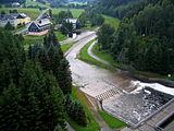
Location Rauschenbach below the dam
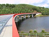
The bridge of the
state road S 211

_2006-07-15.JPG)


See also
literature
- About Olbernhau and Seiffen (= values of our homeland . Volume 43). 1st edition. Akademie Verlag, Berlin 1985.
- Celebration committee 800 years of Cämmerswalde (ed.): Festschrift 800 years of Cämmerswalde. 130 years of the new school , Cämmerswalde 2007
- Hans-Ulrich Sieber (Ed.): Dams in Saxony , Landestalsperrenverwaltung Sachsen, Pirna 1992
Web links
Individual evidence
- ^ Otfried Wagenbreth , Eberhard Wächtler (eds.), A. Becke et al .: Der Freiberg mining. Technical monuments and history . German publishing house for basic industry, Leipzig, 1986, pp. 63, 70
- ↑ Saxon State Office for Environment and Geology