
Arras (Geringswalde)
|
Arras
City of Geringswalde
Coordinates: 51 ° 3 ′ 20 ″ N , 12 ° 54 ′ 0 ″ E
|
||
|---|---|---|
| Incorporation : | January 1, 1999 | |
| Incorporated into: | Geringswalde | |
| Postal code : | 09326 | |
| Area code : | 037382 | |
Location of Arras in Saxony |
||

Arras in the district of Central Saxony is a formerly independent village that was incorporated into Geringswalde on January 1, 1999 .
Geography and traffic
Arras is on Kreisstraße 8270, which connects Holzhausen (on Staatsstraße 200) with Milkau. Roads of local importance connect Arras with Aitzendorf , Geringswalde (both on federal highway 175 ) and Crossen . Arras had a stop on the Waldheim – Rochlitz railway line, which was opened in 1893 and closed in 1998 . Arras is located in the fare zone of the Verkehrsverbund Mittelachsen and has bus connections to Geringswalde, Erlau and Mittweida Monday to Friday .
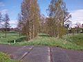
Former Railway line in Arras (2016)
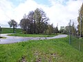
Entrance to the former Arras stop (2016)
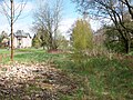
Former Arras stop (2016)

Former Arras stop after all buildings were demolished (2016)

.JPG)
.JPG)
.JPG)
history
The place name is traced back to Flemish settlers who immigrated to the sparsely populated area in the Middle Ages . Its first documentary mention of 1231 is controversial. The place and its inhabitants belonged to the Kriebstein manor in 1551 . In 1696 and 1764, it is documented that it belonged to the Schweikershain manor in the Rochlitz office . During the Wars of Liberation in spring 1813, the residents had to look after 834 soldiers and 751 horses within just four weeks.
The place is dominated by agriculture, but in addition to farmers in Arras there were also numerous craftsmen, in the mid-19th century these were bakers, butchers, blacksmiths, shoemakers, basket makers, wheelwright and tailors.
Web links
- Arras in the Digital Historical Directory of Saxony
Individual evidence
- ^ Arras in the Digital Historical Directory of Saxony
- ↑ Arras | City of Geringswalde. Retrieved March 30, 2019 .