
Administrative community Mittweida
| coat of arms | Germany map | |
|---|---|---|
 Help on coat of arms |
Coordinates: 50 ° 59 ′ N , 12 ° 58 ′ E |
|
| Basic data | ||
| State : | Saxony | |
| County : | Central Saxony | |
| Area : | 55.34 km 2 | |
| Residents: | 16,389 (Dec. 31, 2019) | |
| Population density : | 296 inhabitants per km 2 | |
| License plate : | FG, BED, DL, FLÖ, HC, MW, RL | |
| Association key : | 14 5 22 5119 | |
| Association structure: | 2 municipalities | |
| Association administration address : |
Markt 32, Rathaus Haus 1 09648 Mittweida |
|
| Website : | ||
| Administrative Chairman: | Matthias Damm | |
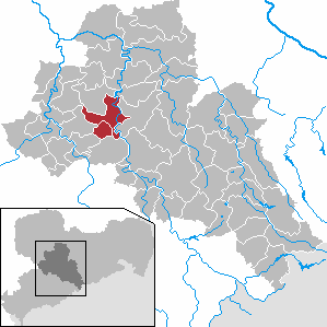
| Location of the Mittweida administrative community in the central Saxony district | ||
  |
||

The Mittweida administrative association is an administrative association in the Free State of Saxony . It is located in the west of the Central Saxony district around the town of Mittweida, about 23 km northeast of Chemnitz . The landscape of the community area is in the Erzgebirge foothills in the central Saxon hill country along the Zschopau valley . The community area can also be reached via the Chemnitz-Ost and Hainichen connections of the federal motorway 4 running south . The Riesa – Chemnitz railway runs through the town of Mittweida.
The municipalities with their districts
- Mittweida with the districts Mittweida (city), Falkenhain, Frankenau, Kockisch, Lauenhain Neudörfchen, Ringethal, Rößgen, Tanneberg, Thalheim, Weißthal and Zschöppichen
- Altmittweida
Individual evidence