Weissbach (Schmölln)
|
Weissbach
City of Schmölln
Coordinates: 50 ° 52 ′ 0 ″ N , 12 ° 19 ′ 2 ″ E
|
||
|---|---|---|
| Height : | 259–292 m above sea level NN | |
| Residents : | 363 (2012) | |
| Incorporation : | March 8, 1994 | |
| Postal code : | 04626 | |
| Area code : | 034491 | |
|
Location of Weißbach in Thuringia |
||
|
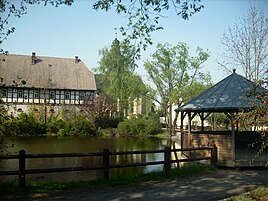
Pond with manor (left) and church (middle)
|
||
Weißbach is a district of the town of Schmölln in the Altenburger Land district in Thuringia .
location
The district of Weißbach is located to the south-west of Schmölln, north of the federal motorway 4 (rest area "Altenburger Land") and can be reached via district roads . The foothills of the Ronneburg arable and mining area extend into the district . Greened erosion channels cheer up the arable area.
history
The district was first mentioned in a document from 1181 to 1214. The manor, first mentioned in the 12th century, was owned by the von Weißbach family until 1570 . This was followed by the von Pflugk and von Schönberg families . In 1598 it was bought by Caspar von Zehmen's family and his descendant sold the Weissbach manor in 1681. Other owners were the von der Planitz and von Pöllnitz families and the previous tenants, Carl Gottfried Friedrich. In the course of the land reform , the manor was expropriated in 1945 and the large barn with horse stable, the stable at the entrance and the brewery were demolished by 1948. The castle was later used as a children's sanatorium, but is now empty.
Weißbach belonged to the Wettin office of Altenburg , which was under the sovereignty of the following Ernestine duchies from the 16th century due to several divisions in the course of its existence : Duchy of Saxony (1554 to 1572), Duchy of Saxony-Weimar (1572 to 1603), Duchy of Saxony-Altenburg (1603 to 1672), Duchy of Saxony-Gotha-Altenburg (1672 to 1826). When the Ernestine duchies were reorganized in 1826, the place came back to the duchy of Saxony-Altenburg. After the administrative reform in the Duchy, Weißbach belonged to the Eastern District (until 1900) and to the Ronneburg District Office (from 1900). From 1918 the village belonged to the Free State of Saxony-Altenburg , which was added to the State of Thuringia in 1920. In 1922 it came to the district of Altenburg .
On July 1, 1950, Brandrübel was incorporated, Selka followed on November 1, 1973. During the second district reform in the GDR in 1952, the existing states were dissolved and the districts re-cut. Thus the community Weißbach came with the district Schmölln to the district Leipzig ; that had belonged to Thuringia since 1990 as the district of Schmölln and became part of the district of Altenburger Land during the Thuringian district reform in 1994 . Shortly beforehand, the community of Weißbach and its two districts were incorporated into the town of Schmölln on March 8, 1994. As of May 1, 2012, 363 people lived in the district. The village is located in rural areas and is characterized by agriculture.
religion
literature
- Christiane Nienhold: ... and in the afternoon we went sailing to Nöbdenitz! Manors in Altenburger Land and their gardens - Part I. Catalog for the exhibition Museum Burg Posterstein 2007, Pöge Druck Leipzig, Posterstein 2007; Pp. 79–81, 116, extensive description of the Weissbach manor
Web links
Individual evidence
- ^ Wolfgang Kahl : First mention of Thuringian towns and villages. A manual. Verlag Rockstuhl, Bad Langensalza, 2010, ISBN 978-3-86777-202-0 , p. 307.
- ^ The Weissbach manor on the Posterstein Castle website
- ^ The Altenburg Office in the book "Geography for all Stands", from p. 201. Retrieved on December 31, 2019 .
- ↑ Adolf Stieler : The locations of the Altenburg office in "Geographical overview of the Saxon-Ernestine, Schwarzburg, Russian and adjacent lands", Gotha 1826, from p. 83. Retrieved on December 31, 2019 .
- ↑ The Eastern District of the Duchy of Saxony-Altenburg in the municipality register 1900. Retrieved on December 31, 2019 .
- ^ The Ronneburg District Office in the 1900 municipal register. Accessed on December 31, 2019 .
- ↑ Weißbach on gov.genealogy.net


