Adolf Stieler
Adolf Stieler (born February 26, 1775 in Gotha ; † March 13, 1836 ibid) was a German cartographer and lawyer who contributed significantly to the development of cartography in Germany . His world atlas laid the basis for Stieler's hand atlas , which was used throughout the 19th and into the middle of the 20th century .
Life
Stieler was born the son of a councilor and mayor. From 1786 to 1793 he attended the Gothaer Gymnasium Illustre and then studied law in Jena and Göttingen . He was employed as a civil servant at the Gothaer Hof in 1796 .
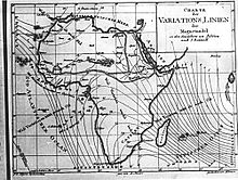
Under Duke Ernst II of Saxony Gotha and Altenburg (1745 / 1772–1804) Gotha had developed into the “Weimar of Natural Sciences”, in which various court officials, in addition to their official duties, also pursued scientific hobbies. Well-known examples are Karl Ernst Adolf von Hoff (1771–1837), the founder of modern geology , and Ernst Friedrich von Schlotheim (1764–1832), who scientifically founded palaeobotany . Stieler was also able to pursue his interests in geography and cartography here and ultimately develop into the founder of atlas cartography in Gotha. On the by Franz Xaver von Zach built observatory Gotha the card designs created at that time in central Europe has been reviewed by Zach himself and judged. This now became aware of the talent of the young Stieler and gave him lessons and suggestions. He also published his first map representations in the General Geographical Ephemeris (Fig.) Published by Friedrich Justin Bertuch (1747-1822) in Weimar . For the same publisher, Stieler drew maps for the great German hand atlas of the time, the general hand atlas of the whole world , as well as for the topographical-military chart of Germany in 204 sections .
Stieler also drew generally recognized maps for other authors, including a map of Germany on a scale of 1: 2,900,000 for the book Das Teutsche Reich before the French Revolution and after the Peace of Luneville by Karl Ernst Adolf von Hoff. Through this work I came into contact with the publisher Justus Perthes , who would last for life.
As early as 1812, Stieler got in touch with Christian Gottlieb Reichard (1758–1837) in order to work with him to design an atlas . The result was presented to the publisher Perthes in 1815. The plan was to create an atlas that would be ... Comfortable format, the greatest possible accuracy, clarity and completeness, but still an appropriate selection, uniform projection and scale, beautiful paper, good printing, careful illumination, affordable price. should distinguish. The first delivery of this atlas appeared in 1817, in 1823 this atlas was temporarily complete with 50 maps (actually only 47 sheets). By then Reichard had contributed around a third of the cards with 16 cards. This Stieler's hand atlas saw numerous editions, which were continued even after Reichard's departure and Stieler's death on March 13, 1836 under the direction of Johann Friedrich von Stülpnagel (1787-1865).
The centenary edition, increased to 108 cards, was published between 1920 and 1925. The atlas was published until 1945. With this, Stieler successfully continued the type of hand atlas that was first developed in Weimar by Adam Christian Gaspari (1752-1830) and Friedrich Justin Bertuch .
Stieler's house was on Karl-Schwarz-Strasse at the corner of Goldbacher Strasse in Gotha. There is still a photo of it from 1858. The successor building, on which there was a memorial plaque, was demolished in autumn 2005.
Literature (selection)
- Jürgen Espenhorst: Andree, Stieler, Meyer & Co. Hand atlants of the German-speaking area (1800–1945) together with forerunners and descendants at home and abroad. Bibliographic manual . Pangea-Verlag, Schwerte 1994, ISBN 978-3-930401-33-8 , pp. 44-137.
- Jürgen Espenhorst: Petermann's Planet. A Guide to German Handatlases And Their Siblings Throughout the World 1800–1950, Vol. 1: The Great Handatlases . Pangea-Verlag, Schwerte 2003, ISBN 978-3-930401-35-2 , pp. 179–346.
- Gottfried Suchy (Hrsg.): Gotha geographers and cartographers. Contributions to the history of geography and cartography . Haack, Gotha 1985. (A text with strong political tones in sections, which is to be understood from the era of the GDR dictatorship. In some parts simply historically incorrect.)
- Steffen Siegel, Petra Weigel: The red pencil of the cartographer. Boundary shifts in “ Stieler's Hand Atlas ” . In: Imagery of Knowledge. Kunsthistorisches Jahrbuch für Bildkritik, Vol. 6 (2008), No. 2: Subject volume “Grenzbilder”, pp. 58–65.
- Friedrich Ratzel : Stieler, Adolf . In: Allgemeine Deutsche Biographie (ADB). Volume 36, Duncker & Humblot, Leipzig 1893, pp. 185-187.
Web links
- 1848 Stieler School Atlas - University of Pennsylvania
- DavidRumsey.com , 1875 Hand-Atlas over all parts of the earth and over the world structure
- 1891 Hand Atlas over all parts of the earth and over the world structure , 95 maps - maproom.org
- Web archive of the large German hand atlases , over 3000 maps - handatlas.de
- Literature by and about Adolf Stieler in the catalog of the German National Library
- Switzerland . Perthes, Gotha 1869 ( digitized version )
Individual evidence
- ↑ 1801 published by Perthes in Gotha, the map by Stieler after p. 276.
- ↑ http://www.gotha.at/Forschung-Stadtgeschichte/ , accessed on November 30, 2017
| personal data | |
|---|---|
| SURNAME | Stieler, Adolf |
| BRIEF DESCRIPTION | German cartographer |
| DATE OF BIRTH | February 26, 1775 |
| PLACE OF BIRTH | Gotha |
| DATE OF DEATH | March 13, 1836 |
| Place of death | Gotha |


