Selka
|
Selka
City of Schmölln
Coordinates: 50 ° 52 ′ 28 " N , 12 ° 18 ′ 30" E
|
||
|---|---|---|
| Height : | 275 (267–281) m above sea level NHN | |
| Residents : | 256 (2012) | |
| Incorporation : | 1st November 1973 | |
| Incorporated into: | Weissbach | |
| Postal code : | 04626 | |
| Area code : | 034491 | |
|
Location of Selka in Thuringia |
||
|
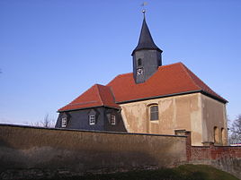
The church
|
||
Selka is a district of the town of Schmölln in the Altenburger Land district in Thuringia .
location
The village is located southwest of Schmölln and also on the Sprotte Valley on the edge of a nature reserve . The district is located in the area of the foothills of the Ronneburg arable and mining area .
Adjacent places are in a clockwise direction beginning in the east Sommeritz and southeast Weißbach as districts of Schmölln as well as west Nöbdenitz , northwest Lohma and north Burkersdorf as districts of Nöbdenitz.
history
The first written mention of the place took place on November 1, 1291. In 1359 Selka was mentioned as a fief of the Weida bailiffs . In the 14th century, the Selka manor was first mentioned, which had developed from a medieval hilltop castle. In 1618 ownership of the manor was divided, resulting in Ober- and Unterselka, the latter as the actual manor. The estate was given a manor house in the 18th century. The castle was rebuilt in the 19th century.
Selka belonged to the Wettin office of Altenburg , which from the 16th century onwards was under the sovereignty of the following Ernestine duchies due to several divisions during its existence : Duchy of Saxony (1554 to 1572), Duchy of Saxony-Weimar (1572 to 1603), Duchy of Saxony-Altenburg (1603 to 1672), Duchy of Saxony-Gotha-Altenburg (1672 to 1826). When the Ernestine duchies were reorganized in 1826, the place came back to the duchy of Saxony-Altenburg. After the administrative reform in the duchy, Selka belonged to the Eastern District (until 1900) and to the Ronneburg District Office (from 1900). From 1918 the village belonged to the Free State of Saxony-Altenburg , which was added to the State of Thuringia in 1920. In 1922 it was first part of the Altenburg district , but was reclassified to the Gera district on January 1, 1927 .
During the second district reform in the GDR in 1952, the existing states were dissolved and the districts were redesigned. Thus Selka came to the Schmölln district in the Leipzig district ; that had belonged to Thuringia since 1990 as the district of Schmölln and became part of the district of Altenburger Land during the Thuringian district reform in 1994 . On November 1, 1973 Selka was incorporated into the municipality of Weißbach , which in turn was incorporated into the town of Schmölln on March 8, 1994. After the reunification, a car dealership opened in the village. In 2012 Selka had 256 inhabitants.
Culture and sights
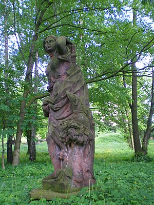
The former neo-Gothic castle from 1869 was blown up on July 20, 1948 on the basis of Order No. 209 of the Soviet Military Administration in Germany . Today only the west wing of the castle from 1739, which served as a widow's seat, still exists. The original allocation plan for the land reform of January 31, 1948 still provided for the preservation of the castle. The demolition stones were used as building materials for new farmhouses a bit away from the village, the so-called settlement. The park with pond is now crossed by a hiking trail. In the park there is still a statue of Diana, the goddess of hunting.
There is a small four-sided courtyard , a former hand-fron estate , located directly at the through-town . All of its buildings are half-timbered. The house is a half-timbered house with a plank room , and there is also an oven extension.
In addition to the former manor, there is the Rock Bock music bar , which has been in existence since 1994 , the restored ruins of the castle's farmyard, which now houses a children's playground, and the listed village church of Selka .
The Landhotel Leedenmühle, a former half-timbered watermill, is located away from the village near the village of Burkersdorf .
Web links
Individual evidence
- ^ Wolfgang Kahl : First mention of Thuringian towns and villages. A manual. Rockstuhl Verlag, Bad Langensalza, 2010, ISBN 978-3-86777-202-0 , p. 262
- ↑ a b Christiane Nienhold, Gustav Wolf, Klaus Hofmann: ... and in the afternoon we went sailing to Nöbdenitz! In: Susann Hesselbarth, Museum Burg Posterstein (Hrsg.): Rittergüter im Altenburger Land and their gardens . Part 1. Self-published, Posterstein 2007, p. 128 .
- ↑ The Selka Manor on the Posterstein Castle website
- ^ Entry on the Selka manor in the private database "Alle Burgen". Retrieved January 17, 2018.
- ^ The Altenburg Office in the book "Geography for all Stands", from p. 201. Accessed on March 26, 2020 .
- ↑ Adolf Stieler : The locations of the Altenburg office in "Geographical overview of the Saxon-Ernestine, Schwarzburg, Russian and adjacent lands", Gotha 1826, from p. 83. Retrieved on March 26, 2020 .
- ↑ The Eastern District of the Duchy of Saxony-Altenburg in the municipality register 1900. Retrieved on March 26, 2020 .
- ^ The Ronneburg District Office in the 1900 municipal register. Accessed on March 26, 2020 .
- ↑ Selka on gov.genealogy.net
- ↑ City portrait: The districts. City administration Schmölln, accessed on May 13, 2019 .


