Sprat (river)
| sprat | ||
|
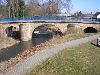
The old bridge over the Sprotte in Schmölln |
||
| Data | ||
| Water code | DE : 56664 | |
| location | Thuringia , Germany | |
| River system | Elbe | |
| Drain over | Pleiße → Weisse Elster → Saale → Elbe → North Sea | |
| source | In four source streams west of Crimmitschau , z. B. near Gera (district Leumnitz ) as Großensteiner Sprotte 50 ° 52 '55 " N , 12 ° 8' 44" E |
|
| Source height | about 309 m (Großensteiner Sprotte) | |
| muzzle | At Saara / Lehndorf in the Pleiße coordinates: 50 ° 56 '17 " N , 12 ° 25' 15" E 50 ° 56 '17 " N , 12 ° 25' 15" E |
|
| Mouth height | about 187 m | |
| Height difference | about 122 m | |
| Bottom slope | about 4.1 ‰ | |
| length | about 30 km | |
| Catchment area | 165.7 km² | |
| Discharge at the Großstöbnitz A Eo gauge : 154.7 km² Location: 4 km above the mouth |
NNQ (1991) MNQ 1983–2015 MQ 1983–2015 Mq 1983–2015 MHQ 1983–2015 HHQ (June 2, 2013) |
68 l / s 228 l / s 662 l / s 4.3 l / (s km²) 11.8 m³ / s 86.8 m³ / s |
| Left tributaries | Litschke | |
| Right tributaries | Lumpitzbach, Koethelbach | |
| Medium-sized cities | Schmoelln | |
The sprat ( Slavic sprotiva - "the stinking") is a tributary of the Pleiße in eastern Thuringia . The upper course of the Sprat consists of four source brooks that arise west of Crimmitschau , namely from
- the northwestern Great Steiner sprat , whose source is in the area of the airfield Gera Leumnitz is
- the Paitzdorfer or Western Sprat , the source of which is near Rückersdorf ,
- the southern Heukewalder sprat , which rises near Nischwitz and
- the eastern Mannichswalder or Postersteiner Sprat , the source of which is near Thonhausen .
Further tributaries of the sprat are the Lumpitzbach, the Köthelbach and the Litschke.
The sprat flows into the Pleiße near Saara and Lehndorf and is about 30 kilometers long over the longest flow path (Großensteiner Sprotte). It is the namesake for the places in the administrative community of Upper Sprottental in the Altenburger Land district .
course
The Großensteiner Sprotte is about 15 kilometers long and thus the longest of the four source streams. It rises on the site of the Gera-Leumnitz airfield, flows through Korbußen, Großenstein , Reichstädt and Löbichau and joins the Mannichswalder Sprat at Burkersdorf , which is about 11 kilometers long.
The Mannichswalder Sprat flows from Thonhausen in a north-westerly direction and takes in the Heukewalder Sprat at Vollmershain , which joins the Heukewalde on the left. Between Posterstein and Nöbdenitz the western Sprat flows towards it, which also joins on the left after it has flowed through the Paitzdorf district of Mennsdorf.
The Mannichswalder Sprotte then flows in a north-easterly direction through the municipality of Nöbdenitz until it merges with the Großensteiner Sprotte near Burkersdorf. From there it flows as sprat further northeast through the town of Schmölln , up to its confluence with the Pleiße north of Saara.
traffic
The Sprotte river valley is partly followed by the railway line from Gera to Altenburg and the federal road 7 .
Web links
Individual evidence
- ↑ a b c d measured with Google Earth
- ↑ Environmental report 1999–2009 ( Memento from June 21, 2015 in the Internet Archive ) Landratsamt Altenburger Land; April 2010; On: altenburgerland.de (pdf; 13.37 MB)
- ↑ Level: Großstöbnitz On: hnz.thueringen.de
swell
- Hydrological manual. (PDF; 115 kB) Part 2 - Area Codes. Free State of Saxony - State Office for Environment and Geology, p. 30 , accessed on December 25, 2017 .
- The Altenburger Land (= values of our homeland . Volume 23). 1st edition. Akademie Verlag, Berlin 1973.
