
Thonhausen
| coat of arms | Germany map | |
|---|---|---|
 Help on coat of arms |
Coordinates: 50 ° 50 ′ N , 12 ° 20 ′ E |
|
| Basic data | ||
| State : | Thuringia | |
| County : | Altenburger Land | |
| Management Community : | Upper Sprottental | |
| Height : | 300 m above sea level NHN | |
| Area : | 9.42 km 2 | |
| Residents: | 525 (Dec. 31, 2019) | |
| Population density : | 56 inhabitants per km 2 | |
| Postal code : | 04626 | |
| Primaries : | 034496, 03762 (Thonhausen) | |
| License plate : | ABG, SLN | |
| Community key : | 16 0 77 047 | |
| Community structure: | 3 districts | |
| Address of the municipal administration: |
Dorfstrasse 42 04626 Thonhausen |
|
| Website : | ||
| Mayor : | André Hupfer | |
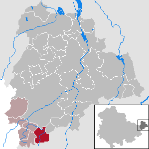
| Location of the municipality of Thonhausen in the Altenburger Land district | ||
  |
||

Thonhausen is a municipality in the south of the Altenburger Land district in Thuringia . It belongs to the administrative community of Upper Sprottental .
geography
Geographical location
The municipality of Thonhausen is located south of the federal motorway 4 in front of the western gate of the city of Crimmitschau at the transition from the Zeitzer-Schmöllner-Lösshügelland to the foothills of the Thuringian Slate Mountains and the Ore Mountains . The Thuringian State Institute for Environment and Geology counts the community in the Ronneburg arable and mining area . The Mannichswalder Sprat flows through Thonhausen . The nearest towns are Crimmitschau (5 km east), Schmölln (7 km north) and Ronneburg (10 km north-west).
Neighboring communities
Neighboring communities are Jonaswalde , Heyersdorf , the town of Schmölln and Vollmershain in the Altenburger Land district and the town of Crimmitschau in the Saxon district of Zwickau .
Community structure
Districts are Thonhausen, Schönhaide and Wettelswalde .
history
The first documentary mention took place in the period from 1181 to 1214. Part of Thonhausen belonged to Sachsen-Altenburg until 1920 and was part of the Ronneburg district office since 1900 . The other part belonged to the Zwickau administration in the Kingdom of Saxony . In 1928 there was an exchange of territory and a border adjustment between the Free State of Saxony and the State of Thuringia . As a result, the splintered areas of the Thuringian part of Thonhausen in Saxony were ceded to Saxony and incorporated into Rudelswalde . The splintered areas of the Saxon part of Thonhausen, however, were combined with the remaining Thuringian part to form one municipality. Both districts and the districts of Schönhaide and Wettelswalde, which were incorporated on July 1, 1950, belonged to the Thuringian district of Altenburg and from July 25, 1952 to the district of Schmölln in the Leipzig district .
church
Population development
The statistics list 568 inhabitants for the Altenburg part of Thonhausen in 1910. Wettelswalde had 123, Schönhaide 120 inhabitants. 110 inhabitants lived in the Saxon part of Thonhausen. In 1933 the places had a total of 868 and in 1939 850 inhabitants.
Development of the population (as of December 31st) :
|
|
|
|
|
- Data source: Thuringian State Office for Statistics
politics


Municipal council
Since the local elections on May 25, 2014 , the local council has been composed as follows:
- Voluntary fire brigade Thonhausen / Schönhaide: 5 seats (67.2%)
- SV 1901 Thonhausen: 2 seats (19.4%)
- Thursday Club: 1 seat (13.4%)
The turnout was 65.6% (+ 8.0% p).
mayor
The 1994 election was won by Birgitt Richter from the CDU in the first ballot with 98.1% of the vote. André Hupfer has been mayor since 1999, elected in the first ballot in 1999 with 98.2%, 2004 with 97.7% (in this election for the CDU), 2010 with 93.5% and 2016 with 90.6% of the votes has been.
coat of arms
The coat of arms of the municipality consists of three fir trees (in the background) and a half-timbered house (in the foreground).
Culture and sights
- see also: List of cultural monuments in Thonhausen
Economy and Infrastructure
The Schönhaide district is located directly at the Schmölln motorway junction of federal motorway 4 . Via the junction, the L 1361 state road leads from Schmölln to Crimmitschau and Neukirchen / Pleiße , which was completely rebuilt in two stages in the municipality and bypasses the localities. The Saxon state road S 61 branches off from the L 1361 to the center of Crimmitschau. The community is part of the Central German Transport Association and is accessible via the bus routes 354 Thonhausen – Heyersdorf – Crimmitschau / Gößnitz – Schmölln, 355 Schmölln – Untschen – Thonhausen and 357 Schmölln – Selka – Weissbach – Brandrübel – Schönhaide – Thonhausen – Nischwitz THÜSAC local passenger transport company connected. The nearest train stations are five kilometers away in Crimmitschau on the Leipzig – Hof railway line and in Nöbdenitz on the Gößnitz – Gera railway line .
Web links
Thonhausen (Saxon Ant.) In the Digital Historical Directory of Saxony
Individual evidence
- ^ Population of the municipalities from the Thuringian State Office for Statistics ( help on this ).
- ^ Geomorphology Altenburger Land. TLUG Jena, accessed on September 30, 2012 .
- ^ Wolfgang Kahl: First mention of Thuringian towns and villages. A manual. Verlag Rockstuhl, Bad Langensalza 2010, ISBN 978-3-86777-202-0 , p. 285.
- ^ Municipal directory Germany 1900 - Duchy of Saxony-Altenburg - District Office Ronneburg. Retrieved September 30, 2012 .
- ↑ Rudelswalde in the Digital Historical Directory of Saxony
- ^ Map with the exchange areas between Saxony and Thuringia in 1928
- ↑ 2014 municipal council elections on the website of the Regional Returning Officer Thuringia , accessed on August 4, 2014
- ↑ Results of the mayoral election on the website of the Regional Returning Officer Thuringia , accessed on August 1, 2016
Altenburg | Dobitschen | Fockendorf | Gerstenberg | Goehren | Göllnitz | Göpfersdorf | Gößnitz | Haselbach | Heukewalde | Heyersdorf | Jonaswalde | Kriebitzsch | Langenleuba-Niederhain | Löbichau | Lödla | Lucka | Mehna | Meuselwitz | Monstrous | Nobitz | Ponitz | Poster stone | Rositz | Schmölln | Starkenberg | Thonhausen | Treben | Vollmershain | Windischleuba