
Poster stone
| coat of arms | Germany map | |
|---|---|---|
 Help on coat of arms |
Coordinates: 50 ° 52 ' N , 12 ° 15' E |
|
| Basic data | ||
| State : | Thuringia | |
| County : | Altenburger Land | |
| Management Community : | Upper Sprottental | |
| Height : | 250 m above sea level NHN | |
| Area : | 5.53 km 2 | |
| Residents: | 467 (Dec. 31, 2019) | |
| Population density : | 84 inhabitants per km 2 | |
| Postal code : | 04626 | |
| Area code : | 034496 | |
| License plate : | ABG, SLN | |
| Community key : | 16 0 77 041 | |
| LOCODE : | DE PO5 | |
| Community structure: | 2 districts | |
| Address of the municipal administration: |
Dorfstrasse 12 04626 Posterstein |
|
| Website : | ||
| Mayor : | Stefan Jakubek | |
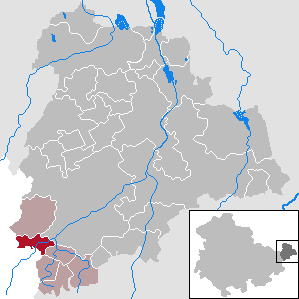
| Location of the community of Posterstein in the Altenburger Land district | ||
  |
||


Posterstein is a municipality in the Altenburger Land district in Thuringia . It is a member and seat of the administrative community of Upper Sprottental .
geography
Geographical location
The western sprat flows through the municipality and merges with the Mannichswalder sprat to the northeast of the municipality. According to the natural structure of the state of Thuringia, the municipality is assigned to the edge of the Altenburg loess area ( Ronneburg arable and mining area ). Most of the municipality's area is used for agriculture, there are only smaller forest areas in the north of the municipality on the left bank of the Western Sprat and in the west of the municipality. The nearest towns are Ronneburg (3 km west), Schmölln (5 km north-east) and Crimmitschau (7 km south-east).
geology
In the so-called fracture field of Posterstein , faults run through the series of layers of Silurian , Devonian and Carboniferous as well as volcanic breakthroughs of porphyry , diabase and melaphyre . A widely perceptible earthquake last occurred in this fault zone in 1872.
Neighboring communities
Neighboring communities are Heukewalde , Löbichau , Vollmershain and the town of Schmölln in the Altenburger Land district and Paitzdorf and the town of Ronneburg in the Greiz district .
Community structure
Districts are Posterstein and Stolzenberg .
history
Posterstein was first mentioned in a document on April 14, 1191. In the 15th century the Puster family owned the castle "Stein" , from which the present name comes. At the end of the 13th century , the governors of Weida succeeded in gaining feudal rule over Posterstein. When the Reuss parent company split in 1305 into Reuss older line ( Plauen ) and Reuss younger line ( Greiz ), Posterstein remained under the rule of the younger line. The Russians opposed the efforts of the Wettin Margraves of Meissen to expand their rule in the Pleißenland . In order to counter the pressure of the margraves, the bailiffs offered the rule of Posterstein to the king of Bohemia as a fief. Margrave Friedrich the Serious then complained to the emperor. The feudal rule was controversial until the 17th century . In the period after the Vogtland War (1354–1359), a large part of the Posterstein estates came under Meißner rule, while Posterstein itself remained Vögtisches (Reussian) fiefdom.
Posterstein belonged to the Wettin office of Altenburg , which was under the sovereignty of the following Ernestine duchies from the 16th century due to several divisions in the course of its existence : Duchy of Saxony (1554 to 1572), Duchy of Saxony-Weimar (1572 to 1603), Duchy of Saxony-Altenburg (1603 to 1672), Duchy of Saxony-Gotha-Altenburg (1672 to 1826). When the Ernestine duchies were reorganized in 1826, the place came back to the duchy of Saxony-Altenburg. After the administrative reform in the duchy, Posterstein belonged to the Eastern District (until 1900) and to the Ronneburg District Office (from 1900). From 1918 the village belonged to the Free State of Saxony-Altenburg , which was added to the State of Thuringia in 1920. In 1922 it came to the district of Gera .
On July 1, 1950, the previously independent community of Stolzenberg was incorporated. In 1952, Posterstein came from the Gera district to the Schmölln district , through which it came to the Altenburger Land district in 1994. During the second district reform in the GDR in 1952, the existing states were dissolved and the districts were redesigned. Thus, the Posterstein community came from the Gera district to the Schmölln district in the Leipzig district , which had belonged to Thuringia since 1990 as the Schmölln district and which became part of the Altenburger Land district during the Thuringian district reform in 1994 . Since October 12, 1994, the community of Posterstein has belonged to the administrative community of Upper Sprottental .
After the Second World War, uranium ore mining developed by SDAG Wismut in the region around Ronneburg . Between 1956 and 1960, the "Stolzenberg opencast mine" was driven between the A4 federal motorway in the north and the Stolzenberg district in the south. Between 1974 and 1977 the Stolzenberg opencast mine was tipped with material from the depths of the shafts in Beerwalde and covered with cultivated soil. As part of the renaturation, the Stolzenberg dump was partially profiled between 1977 and 1979 and the slopes flattened.
Population development
In 1910, Posterstein and Stolzenberg lived together 436 inhabitants, in 1933 there were 432 inhabitants.
Development of the population (as of December 31st) :
|
|
|
|
|
- Data source: Thuringian State Office for Statistics
politics
Municipal council
Since the local elections on May 25, 2014 , the local council has been composed as follows:
- Citizens' initiative of the SPD - 4 seats (50.8%)
- Per country and people - 2 seats (49.2%)
The turnout was 63.9% (-4.2% p).
mayor
Mayor has been Stefan Jakubek since August 1, 1992, who was elected either for the SPD or the SPD's citizens' initiative in the mayoral elections until 2004. He was last confirmed in office on June 5, 2016 with a majority of 93.0% without opposing candidates and a voter turnout of 54.3% (- 0.3% p).
Culture and sights
- see also: List of cultural monuments in Posterstein
- The most striking building is the Postersteiner Burg , which, when illuminated at night, is easily recognizable from the BAB 4 north of the community . A castle church also belongs to the castle . The late Gothic church is decorated with lavish wood carvings from 1689 by the otherwise unknown artist Johannis Hopf.
- Rittergut Posterstein southwest of the castle: The historic mansion, which has been vacant for years, is to be fundamentally renovated in 2016 and 2017 with investment costs of 3.4 million euros. Eight apartments and two holiday apartments and rooms for day care for the elderly are to be built in the building.
Economy and Infrastructure
The district road K 503 connects Posterstein and Stolzenberg with Nöbdenitz and the state road L 1081, which in turn leads to federal road 7 and to the Ronneburg junction of the BAB 4. The community is part of the Central German Transport Association and is connected to the 355 Schmölln – Untschen – Thonhausen bus of the THÜSAC local passenger transport company , which runs on weekdays except Saturdays . The closest connection to local rail transport is two kilometers northeast in Nöbdenitz.
Personalities
- Veit Ulrich von Beulwitz (1899–1934), politician ( NSDAP ) and high-ranking SA leader, killed in the " Röhm Putsch "
Web links
Individual evidence
- ^ Population of the municipalities from the Thuringian State Office for Statistics ( help on this ).
- ↑ Wolfgang Kahl: First mention of Thuringian cities and villages up to 1300 . Verlag Rockstuhl, Bad Langensalza 2001, ISBN 3-934748-58-9 , p. 48 .
- ↑ Thomas Bienert: Medieval castles in Thuringia . Wartberg Verlag, 2000, ISBN 3-86134-631-1 , p. 22 .
- ^ The Altenburg Office in the book "Geography for all Stands", from p. 201
- ^ The locations of the Altenburg district from p.83
- ↑ The eastern district of the Duchy of Saxony-Altenburg in the municipal directory 1900
- ^ The district office of Ronneburg in the municipality register 1900
- ^ Posterstein on the website of the Posterstein community
- ^ The Stolzenberg opencast mine on the website of the Ronneburg Mining Association
- ^ Municipal directory Germany 1900 - Duchy of Saxony-Altenburg - District Office Ronneburg. Retrieved October 25, 2012 .
- ↑ Michael Rademacher: German administrative history from the unification of the empire in 1871 to the reunification in 1990. City and district of Gera. (Online material for the dissertation, Osnabrück 2006).
- ↑ 2014 municipal council elections , accessed on August 4, 2014.
- ↑ A village celebrates its mayor in Posterstein. Ostthüringer Zeitung, local part Altenburg, accessed on October 25, 2012 .
- ^ Results of the mayoral election. Regional Returning Officer Thuringia, accessed on August 1, 2016 .
- ^ Friedrich Ludwig Müller (Ed.): Curiosities from the monument landscape . Of earthly and heavenly creatures. tape 1 . Monuments publications, Bonn 1998, ISBN 978-3-936942-69-9 , p. 24, 26 (96 pp.).
- ↑ Thuringian General of August 18, 2016
Altenburg | Dobitschen | Fockendorf | Gerstenberg | Goehren | Göllnitz | Göpfersdorf | Gößnitz | Haselbach | Heukewalde | Heyersdorf | Jonaswalde | Kriebitzsch | Langenleuba-Niederhain | Löbichau | Lödla | Lucka | Mehna | Meuselwitz | Monstrous | Nobitz | Ponitz | Poster stone | Rositz | Schmölln | Starkenberg | Thonhausen | Treben | Vollmershain | Windischleuba