
Lödla
| coat of arms | Germany map | |
|---|---|---|

|
Coordinates: 51 ° 0 ' N , 12 ° 23' E |
|
| Basic data | ||
| State : | Thuringia | |
| County : | Altenburger Land | |
| Management Community : | Rositz | |
| Height : | 200 m above sea level NHN | |
| Area : | 4.32 km 2 | |
| Residents: | 706 (Dec. 31, 2019) | |
| Population density : | 163 inhabitants per km 2 | |
| Postal code : | 04617 | |
| Primaries : | 03447, 034498 (Unterlödla and Wieseberg) | |
| License plate : | ABG, SLN | |
| Community key : | 16 0 77 027 | |
| Community structure: | 4 districts | |
| Address of the municipal administration: |
Hirtenweg 3 OT Oberlödla 04617 Lödla |
|
| Website : | ||
| Mayor : | Torsten Weiß ( CDU ) | |
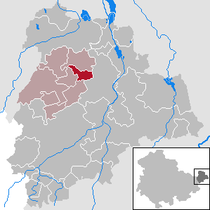
| Location of the community Lödla in the Altenburger Land district | ||
  |
||

Lödla is a municipality in the administrative community Rositz in the Thuringian district of Altenburger Land . It is located about 4 km west of the district town of Altenburg .
geography

Lödla is located in the Altenburg-Zeitzer Loess hill country . The Gerstenbach , a tributary of the Pleiße, flows through the village . Neighboring communities are (clockwise) Rositz , the city of Altenburg , Göhren and Monstab .
Community structure
The municipality of Lödla is made up of the districts Oberlödla and Unterlödla . The settlements Rödigen , Wieseberg and Wilhelm-Pieck-Siedlung are located in the Oberlödla district .

history
The municipality of Lödla in the Thuringian district of Altenburg was created on July 1, 1950 through the merger of the municipality of Oberlödla with its district Rödigen with the municipality of Unterlödla, whereby Oberlödla remained the main town of the new municipality. During this time, Wieseberg was also reclassified from Lossen to Lödla. After the land reform , the Wilhelm-Pieck-Siedlung was built east of Oberlödla on the disused Herzog-Ernst-Schacht . It consisted of ten new farmer positions. The farmers founded a type I LPG as early as 1952 , which later joined the type III in Monstab . In the course of the territorial reform in the GDR, Lödla was assigned to the Altenburg district in the Leipzig district in 1952 . In 1953 lignite mining ended in the Oberlödla district. In 1966 a new kindergarten was built in the main town of Oberlödla.
With the re-establishment of the federal states in 1990, Lödla and the Altenburg district were reassigned to the Free State of Thuringia . Since the district reform in Thuringia in 1994, Lödla has belonged to the Altenburger Land district. In the immediate vicinity of the Wilhelm-Pieck-Siedlung , the now almost fully occupied industrial area of the community of Lödla was built. It is located directly on the B180 in the immediate vicinity of the outskirts of Altenburg and employs around 200 people.
Development of the population
(December 31st) :
|
|
|
|
|
- Data source: Thuringian State Office for Statistics
traffic
The north-eastern edge of Oberlödla is affected by the federal highway 180 . The Zeitz – Altenburg railway line, which also runs north-east of the local edge, has been closed. The nearest train station is now in Altenburg . There is also a connection to the Central German S-Bahn .
Personalities
- Karl von Poellnitz (1896–1945), botanist, manor owner of Oberlödla and honorary member of the "Natural Research Society of the Osterland"
politics
mayor
The SPD politician Sabine Franke was the mayor until the election on June 5, 2016 . Since then, Torsten Weiß, who is a candidate on the CDU list, has been the incumbent. With a turnout of 72.0% (+ 23.8% p) and a majority of 55.1%, he prevailed over his competitor Ramona Meuschke from the SPD.
Municipal council
Since the local elections on May 25, 2014 , the local council has been composed as follows:
- CDU / Voting Group Lödla - 3 seats (40.1)
- SPD - 4 seats (48.2%)
- Independent voter community Lödla (UWL) - 1 seat (11.7%)
The turnout was 62.7%.
Web links
Individual evidence
- ^ Population of the municipalities from the Thuringian State Office for Statistics ( help on this ).
- ↑ Lödla on gov.genealogy.net
- ^ The Altenburger Land (= values of our homeland . Volume 23). 1st edition. Akademie Verlag, Berlin 1973.
- ↑ VG Rositz website
- ↑ Results of the mayoral elections on the website of the Land Returning Officer Thuringia , accessed on July 31, 2016
Altenburg | Dobitschen | Fockendorf | Gerstenberg | Goehren | Göllnitz | Göpfersdorf | Gößnitz | Haselbach | Heukewalde | Heyersdorf | Jonaswalde | Kriebitzsch | Langenleuba-Niederhain | Löbichau | Lödla | Lucka | Mehna | Meuselwitz | Monstrous | Nobitz | Ponitz | Poster stone | Rositz | Schmölln | Starkenberg | Thonhausen | Treben | Vollmershain | Windischleuba