
Linda b. Weida
| coat of arms | Germany map | |
|---|---|---|

|
Coordinates: 50 ° 48 ' N , 12 ° 11' E |
|
| Basic data | ||
| State : | Thuringia | |
| County : | Greiz | |
| Management Community : | Wish village / Elster | |
| Height : | 320 m above sea level NHN | |
| Area : | 8.84 km 2 | |
| Residents: | 443 (Dec. 31, 2019) | |
| Population density : | 50 inhabitants per km 2 | |
| Postal code : | 07580 | |
| Area code : | 036608 | |
| License plate : | GRZ, ZR | |
| Community key : | 16 0 76 043 | |
| Address of the municipal administration: |
Kirchweg 4 07580 Linda b. Weida |
|
| Website : | ||
| Mayor : | Alexander Zill (Fire Brigade / SV Linda) | |
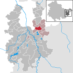
| Location of the community Linda b. Weida in the district of Greiz | ||
  |
||

Linda b. Weida is a municipality in the Thuringian district of Greiz . It belongs to the administrative community Wünschendorf / Elster .
geography
Geographical location

Linda is located in the Ronneburg arable and mining area . The community area is mainly used for agriculture, only in the south there are smaller forest areas and a water reservoir that drains to the Fuchsbach and on to the White Elster . The Wipse runs on the northern edge of the municipality, which rises not far from the municipality boundary in Erlicht and flows into the Elster at Gera-Liebschwitz . The regional watershed between the White Elster and the Pleiße is located in the northeastern municipality . The nearest towns are Ronneburg (6 km north), Berga / Elster (7 km south), Weida (10 km south-west) and Gera (city center; 12 km north-west).
Neighboring communities
Neighboring communities are Berga / Elster (city), Braunichswalde , Endschütz , Gauern , Hilbersdorf and Rückersdorf in the district of Greiz and the independent city of Gera . Gera only borders indirectly with the Kleinfalke district .
Community structure
Linda owns a single district with Pohlen , which was incorporated on March 1, 1970.
history
Linda was first mentioned in 1307 in a document from the Cronschwitz monastery . During the Thirty Years War , Swedish troops burned ten houses in April 1640. In 1865 a cholera epidemic ravaged the place. Around 1900 there was the "Bad Linda", known as the "mineral and mud bath". Mineral and medicinal water deposits were probably discovered in Linda around 1800, as well as moors. Both were used for healing purposes. In 1920 the buildings for bathing were sold to the Erfurt General Local Health Insurance Fund, which used them as a convalescent home. During the GDR era, there were children's and old people's homes in the buildings. Until 1918 the village belonged to Sachsen-Altenburg and from 1900 it belonged to the district office of Ronneburg . In 1922 it went to the district of Gera . In 1952, Linda briefly belonged to the Schmölln district , but went to the Gera-Land district that same year .
Religions
Linda belongs to the diocese of Dresden-Meißen . The Evangelical Lutheran parish Linda belongs to the parish area Großenstein-Soon Park in the church district Altenburger Land of the Evangelical Church in Central Germany . The Evangelical Church is essentially of Romanesque origin. The exterior of the church is characterized by various modifications.
Population development
In 1910 there were 447 inhabitants in Linda, in 1933 there were 467 inhabitants. For Pohlen, exactly 100 inhabitants are given in the same year.

Development of the population (as of December 31st) :
|
|
|
|
|
- Data source: Thuringian State Office for Statistics
politics
Municipal council

The municipal council was determined by a majority vote in the local elections on May 26, 2019 . The six community council members are united in the joint list of the Linda sports group and the Linda volunteer fire department. The turnout was 79.2%, which is 12.5% higher than in 2014.
mayor
The mayoral election in 1994 was won by Adele Stephan from the CDU with 81.5% of the valid votes. In the runoff election on June 27, 1999, she was defeated by Rainer Merkel, who received 68.0% of the vote. Rainer Merkel joined the CDU in 2004 and was confirmed in office with 84.6% of the votes. In the election on June 6, 2010, Alexander Zill (SG Linda / FFW Linda) prevailed against Rainer Merkel with 69.9% of the votes in the first ballot. The incumbent Alexander Zill took office again on June 5, 2016 and was confirmed in office with 95.3% of the votes. The turnout was 65.0%.
Economy and Infrastructure
Linda lies on the national road L 1082 of Rückersdorf according Pohlen. In Pohlen, the road continues as L 2321 to Gera-Unterröppisch . The L 2336 connects Linda with Berga. District roads connect Pohlen with Endschütz and Rußdorf , a narrow local road with a concrete road leads from Linda to Braunichswalde. On working days except Saturdays, the bus route 219 Gera – Wünschendorf – Linda – Wolfersdorf – Seelingstädt operated by RVG Regionalverkehr Gera / Land . Since 1956, the Seelingstädt – Paitzdorf line of the Wismut-Werkbahn has been running through the municipality. Since the end of travel on the Wünschendorf – Werdau railway line , the closest access to local rail transport is in Wünschendorf / Elster .
Web links
Individual evidence
Auma-Weidatal | Bad Köstritz | Berga / Elster | Bethenhausen | Bocka | Brahmenau | Braunichswalde | Caaschwitz | Crimla | End contactor | Gurgling | Greiz | Grossenstein | Harth-Pöllnitz | Hartmannsdorf | Hilbersdorf | Hirschfeld | Hohenleuben | Dog heads | Crouch | Basket feet | Power Village | Kühdorf | Langenwetzendorf | Langenwolschendorf | Lederhose | Linda b. Weida | Linden Cross | Mohlsdorf-Teichwolframsdorf | Münchenbernsdorf | Paitzdorf | Pölzig | Reichstädt | Ronneburg | Rückersdorf | Saara | Schwaara | Schwarzbach | Seelingstädt | Teichwitz | Weida | Weißendorf | Wish village / Elster | Zedlitz | Zeulenroda shoot
- ^ Population of the municipalities from the Thuringian State Office for Statistics ( help on this ).
- ^ Postcard sent in 1902
- ↑ Presentation by TU Freiberg , accessed on October 26, 2018
- ^ A b Register of municipalities in Germany 1900 - Duchy of Saxony-Altenburg - Ronneburg district office. Retrieved September 24, 2012 .
- ↑ parish Linda on EKMD
- ↑ Local election results 2014