
Power village
| coat of arms | Germany map | |
|---|---|---|

|
Coordinates: 50 ° 53 ' N , 11 ° 55' E |
|
| Basic data | ||
| State : | Thuringia | |
| County : | Greiz | |
| Height : | 270 m above sea level NHN | |
| Area : | 41.24 km 2 | |
| Residents: | 3726 (Dec. 31, 2019) | |
| Population density : | 90 inhabitants per km 2 | |
| Postal code : | 07586 | |
| Primaries : | 036606, 0365 (pottery) | |
| License plate : | GRZ, ZR | |
| Community key : | 16 0 76 089 | |
| LOCODE : | DE KFF | |
| Address of the municipal administration: |
Straße der Einheit 63 07586 Kraftsdorf |
|
| Website : | ||
| Mayor : | Bernd Becker | |
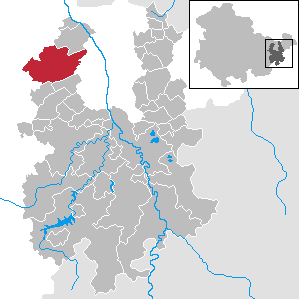
| Location of the municipality of Kraftsdorf in the district of Greiz | ||
  |
||

Kraftsdorf is a Thuringian municipality in the district of Greiz near Gera . An important branch of the economy is the manufacture of sausage products.
geography
The actual power village and the districts of Töppeln, Niederndorf, Harpersdorf and Oberndorf are located in the Erlbach valley . Rüdersdorf, Grüna, Pörsdorf and Mühlsdorf are located on a plateau north of the Erlbach Valley. Kaltenborn lies south of it in a side valley. It has a train station on the Weimar – Gera railway line and the “Hermsdorf-Ost” and “Rüdersdorf” motorway exits on federal motorway 4 .
Neighboring communities
Neighboring communities are Bad Köstritz , Hartmannsdorf , Lindenkreuz and Saara in the district of Greiz, Bad Klosterlausnitz , the city of Hermsdorf , Reichenbach , St. Gangloff and Tautenhain in the Saale-Holzland district and the independent city of Gera .

Community structure
The unified community Kraftsdorf consists of four localities with a total of ten villages:
- Kraftsdorf village
- Harpersdorf
- Power village
- Oberndorf
- Village of Niederndorf
- Rüdersdorf village
- Grüna
- Rüdersdorf (with Stübnitz )
- Töppeln village
history
Kraftsdorf was first mentioned in a document in 1256, when Margrave Heinrich von Meißen transferred the two villages of Kraftsdorf and Hermsdorf to the Lausnitz monastery . Kraftsdorf was divided into an Altenburg and a Russian part until 1920.
The Altenburg part belonged to the Wettin district office of Eisenberg , which was under the sovereignty of various Ernestine duchies due to several divisions in the course of its existence . The Russian part belonged to the rule of Gera of the Principality of Reuss younger line . From 1920 both districts belonged to the Free State of Thuringia.
In 1876 the Weimar-Gera railway line was inaugurated and the Kraftsdorf train station went into operation. As a result, the stonemasonry in the sandstone took a great boom. Its products were used in the construction of the Göltzschtal bridge . On October 1, 1922, the two separate districts were merged (Altenburg part with 142 people, Russian part with 644 people) 1919 census results
Otto Vestewig (1909–1944) from Kraftsdorf was executed as a Wehrmacht deserter on April 28, 1944 for "desertion" in the Brandenburg-Görden prison.
In 1936 the Wehrmacht established the air ammunition facility 5 / IV (Muna) in the forest near Oberndorf , and later prisoners from the Buchenwald concentration camp were also used. Up to 500 prisoners were housed in the camp, who drove aisles into the forest and erected wooden pillars to store bombs. 400 prisoners were herded on two death marches in 1945. A memorial stone in the park of the Stadtroda State Hospital has been commemorating her since 1985 .
Religions

Four religious communities are known in the community. The largest group is the Ev.-Luth. Parish. It includes the church in Kraftsdorf and the churches in Harpersdorf, Niederndorf, Mühlsdorf, Pörsdorf, Rüdersdorf and Reichhardtsdorf. The districts of Kaltenborn and Grüna also fall into the pastoral care district. Christian Kurzke has been the pastor of the parish since May 2006. Parish seat of the parish is Rüdersdorf. Other religious communities are the Evangelical Free Church, the Roman Catholic Church and the New Apostolic Church. The church of the New Apostolic Church can be found in the district of Oberndorf and that of the Roman Catholic Church. St. Josef parish in neighboring Hermsdorf.
Incorporations
On January 1, 1997, the previously independent communities Kraftsdorf (since July 1, 1950 with Harpersdorf and Oberndorf), Niederndorf (since July 1, 1950 with Kaltenborn), Rüdersdorf (since July 1, 1950 with Grüna) and Töppeln ( since July 1, 1950 with Mühlsdorf and Pörsdorf) merged into a unified municipality.
Population development
Development of the population (as of December 31st):
|
|
|
|
|
- Data source: Thuringian State Office for Statistics
Culture and sights
The football club Kraftsdorfer SV 03 has a football pitch with a home for athletes. At the end of the 2007/2008 season, the football team was promoted to the regional class East (7th division). Furthermore, TSV 1880 Rüdersdorf can be found in the district of Rüdersdorf, which has a sports facility with a sports center, outside cabin, training and sports field. In the community there is a maypole setters association in almost every district.
Economy and Infrastructure
economy
Starting November 16, 2010, the largest open space solar park in Thuringia will be built in the district of Rüdersdorf on behalf of Solaris Kraftwerk GmbH , under the patronage of the Thuringian Ministry of Construction and using Chinese PV modules. The cost of the system is just under 20 million euros, the annual output is given as 7 million kilowatt hours.
traffic

The Federal Motorway 4 with the Rüdersdorf junction and the Weimar – Gera railway with the Kraftsdorf station , the Töppeln station and the former Oberndorf block run through the area of the Kraftsdorf community .
The stations / stops (now only required maintenance ) are every hour by the commuter train line RB 21 Weimar - Jena West - Jena Göschwitz - Stadtroda - Hermsdorf-Klosterlausnitz - Gera main station to the region and the transfer stations to long-distance and regional transport tethered . The Geraer Verkehrsbetriebe maintains line 20 from Gera-Untermhaus to Harpersdorf. The end of the line is the sports hall in Harpersdorf. There is also a regular regional bus connection from Gera via Kraftsdorf to Hermsdorf.
education
The municipality of Kraftsdorf has 4 kindergartens with after-school care, a primary school and a sports hall. In June 2007, the conversion of the former Harpersdorf regular school into a primary school was ceremoniously completed. Before that, the primary school was housed in Töppeln.
natural reserve
At the end of 2009, the Weimar State Administration prohibited the construction of three wind turbines near Rüdersdorf and in January 2010 the construction of seven wind turbines (planned height 150 m) near Kraftsdorf. The reason was: incompatibility with nature conservation , especially bird and bat protection.
Personalities
The painter Kurt Günther (1893–1955) lived in Kaltenborn from 1932.
Individual evidence
- ^ Population of the municipalities from the Thuringian State Office for Statistics ( help on this ).
- ↑ Heimatgeschichtlicher Wegweiser to Places of Resistance and Persecution 1933–1945 , Volume 8 Thuringia; Edited by TVVdN-BdA and the German Resistance Study Group 1933–1945 ; Hamburg undated, ISBN 3-88864-343-0 , p. 115
- ^ StBA: Changes in the municipalities, see 1997
- ↑ Construction of wind farms prohibited . Thuringian newspaper, January 21, 2010
Web links
- www.kraftsdorf.de - website of the municipality
- www.landkreis-greiz.de - Information on the municipality of Kraftsdorf on the official website of the district of Greiz
Auma-Weidatal | Bad Köstritz | Berga / Elster | Bethenhausen | Bocka | Brahmenau | Braunichswalde | Caaschwitz | Crimla | End contactor | Gurgling | Greiz | Grossenstein | Harth-Pöllnitz | Hartmannsdorf | Hilbersdorf | Hirschfeld | Hohenleuben | Dog heads | Crouch | Basket feet | Power Village | Kühdorf | Langenwetzendorf | Langenwolschendorf | Lederhose | Linda b. Weida | Linden Cross | Mohlsdorf-Teichwolframsdorf | Münchenbernsdorf | Paitzdorf | Pölzig | Reichstädt | Ronneburg | Rückersdorf | Saara | Schwaara | Schwarzbach | Seelingstädt | Teichwitz | Weida | Weißendorf | Wish village / Elster | Zedlitz | Zeulenroda shoot
Village Kraftsdorf with Harpersdorf , Kraftsdorf and Oberndorf | Village of Niederndorf with Kaltenborn and Niederndorf | Village of Rüdersdorf with Grüna and Rüdersdorf (with Stübnitz ) | Village of Töppeln with Mühlsdorf , Pörsdorf and Töppeln