
Harpersdorf
|
Harpersdorf
Community Kraftsdorf
Coordinates: 50 ° 52 ′ 39 ″ N , 11 ° 56 ′ 49 ″ E
|
|
|---|---|
| Height : | 246 m |
| Incorporation : | July 1, 1950 |
| Postal code : | 07586 |
| Area code : | 036606 |
 Location of Harpersdorf in Kraftsdorf
|
|
 |
|
Harpersdorf is a district of Kraftsdorf in the Greiz district in Thuringia .
geography
Harpersdorf is located east of Kraftsdorf and has a similar geographic location to the core community. The place is on the state road 1070 and on Erlbach . It is flanked to the north by federal motorway 4 . The Gera- Hermsdorf federal railway line also runs through the corridor . Seen from afar is the Tümmelsberg with a peak altitude of 361.5 meters above sea level. In Harpersdorf the Tesse flows into the Erlbach , a tributary of the White Elster whose course the main road follows.
history
The village was first mentioned on April 13, 1333. In 1818 the Harpersdorf village church was consecrated, which was destroyed in a bomb attack in 1945 and rebuilt in 1946.
On July 1, 1950, the farming villages of Oberndorf and Harpersdorf were incorporated into Kraftsdorf. Harpersdorf remained the school location. Harpersdorf is the focus of the EU-funded village renewal program, through which extensive modernization measures were financed, especially in 2013.
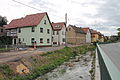
Erlbach

church

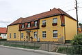
school
Inn


Individual evidence
- ^ Wolfgang Kahl : First mention of Thuringian towns and villages. A manual. Rockstuhl Verlag, Bad Langensalza, 2010, ISBN 978-3-86777-202-0 , p. 110
- ↑ Harpersdorf on the website of the Kraftsdorf community. Accessed January 31, 2012
- ↑ Free State of Thuringia: Funding priorities in the village renewal program in 2013. (PDF) Archived from the original on January 5, 2014 ; accessed on June 3, 2017 .
Web links
Village Kraftsdorf with Harpersdorf , Kraftsdorf and Oberndorf | Village of Niederndorf with Kaltenborn and Niederndorf | Village of Rüdersdorf with Grüna and Rüdersdorf (with Stübnitz ) | Village of Töppeln with Mühlsdorf , Pörsdorf and Töppeln