
Tautenhain
| coat of arms | Germany map | |
|---|---|---|
 Help on coat of arms |
Coordinates: 50 ° 55 ' N , 11 ° 55' E |
|
| Basic data | ||
| State : | Thuringia | |
| County : | Saale-Holzland district | |
| Fulfilling municipality : | Bad Klosterlausnitz | |
| Height : | 330 m above sea level NHN | |
| Area : | 8.96 km 2 | |
| Residents: | 922 (Dec. 31, 2019) | |
| Population density : | 103 inhabitants per km 2 | |
| Postal code : | 07639 | |
| Area code : | 036601 | |
| License plate : | SHK, EIS, SRO | |
| Community key : | 16 0 74 098 | |
| Association administration address: | Markt 3 07639 Bad Klosterlausnitz |
|
| Website : | ||
| Mayor : | Daniel Steuer | |
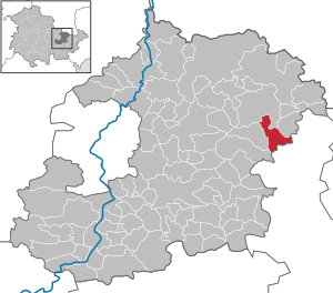
| Location of the municipality of Tautenhain in the Saale-Holzland district | ||
  |
||

Tautenhain is a municipality in the east of the Saale-Holzland district in the Free State of Thuringia . The fulfilling municipality is Bad Klosterlausnitz . It is one of the woodland communities that gave the district part of its name.
geography
Neighboring communities
Neighboring communities are Bad Klosterlausnitz , the city of Eisenberg , Silbitz and Weißenborn in the Saale-Holzland district and the city of Bad Köstritz (OT Reichardtsdorf) and Kraftsdorf in the district of Greiz .
history
The place was first mentioned on January 13, 1284. Above the sky ground 2 km east of the place on the Burgstädel was a castle. It was probably a high medieval manor house.
Tautenhain belonged to the Wettin district office of Eisenberg , which was under the sovereignty of various Ernestine duchies due to several divisions in the course of its existence . In 1826 the place came with the southern part of the Eisenberg district office and the city of Eisenberg from the Duchy of Saxony-Gotha-Altenburg to the Duchy of Saxony-Altenburg . From 1920 he belonged to the Free State of Thuringia.
On the way to the battle of Jena and Auerstedt in 1806 - coming from Köstritz - Napoleon's troops marched through the village who had left a defective cannon. The inn "Zur Kanone" is named after this.
Tautenhain was a climatic health resort until 1974. The stationing of missile troops of the NVA in the nearby forest on 135 hectares was the reason to withdraw the visit of vacationers to the place. The units of the 3rd Missile Brigade were stationed here from May 1975 to 1990.
From around 1960, the district institute for agriculture and later a follow-up facility with experts, technicians and laboratory assistants were active in the village. In 1962, after the university reform, the agricultural library was moved to Tautenhain after the agricultural faculty in Jena was dissolved. On December 31, 1991, the Tautenhain facility was wound up and the library relocated back to LUFA Jena, based in Zwatzen.
Population development
Development of the population (December 31) :
|
|
|
|
|
- Data source: Thuringian State Office for Statistics

Culture and sights
The Johanniskirche was built in 1743.
The annual maypole-setting is local tradition, as is the children's maypole-setting.
The Musikverein Tautenhain eV with 16 active musicians is dedicated to brass music.
Individual evidence
- ^ Population of the municipalities from the Thuringian State Office for Statistics ( help on this ).
- ^ Wolfgang Kahl : First mention of Thuringian towns and villages. A manual. 5th, improved and considerably enlarged edition. Rockstuhl, Bad Langensalza 2010, ISBN 978-3-86777-202-0 , p. 282.
- ↑ Michael Köhler: Thuringian castles and fortified prehistoric and early historical living spaces. Jenzig-Verlag Köhler, Jena 2001, ISBN 3-910141-43-9 , p. 77.
- ↑ Tourist Thuringia Saale Valley. Internet, 2011.
- ^ Heike Brückner: History and inventory of the agricultural science library Jena. In: Thuringian State Agency for Agriculture. History booklet. 8 = Thuringian State Institute for Agriculture. Series of publications. Issue 13, 2002, ISSN 0944-0348 , pp. 98-108.
- ^ Karl Egerer: On the history of agriculture in East Thuringia from 1945 to 1989. In: Thuringian State Institute for Agriculture. History booklet. 3 = Thuringian State Agency for Agriculture. Series of publications. No. 5, 1996, pp. 61-107.
Web links
Albersdorf | Altenberga | Bad Klosterlausnitz | Bibra | Bobeck | Bremsnitz | Bucha | Bürgel | Crossing the Elster | Dornburg-Camburg | Eichenberg | Eineborn | Eisenberg | Frauenprießnitz | Outdoor orla | Geisenhain | Gneus | Golmsdorf | Gosen | Graitschen at Bürgel | Greater buckedra | Grosseutersdorf | Großlöbichau | Großpürschütz | Gumperda | Hainichen | Hainspitz | Hartmannsdorf | Heathland | Hermsdorf | Hummelshain | Jenalöbnitz | Kahla | Karlsdorf | Little buckedra | Kleinebersdorf | Kleineutersdorf | Laasdorf | Lehesten | Lindig | Lippersdorf-Erdmannsdorf | Löberschütz | Mertendorf | Meusebach | Milda | Möckern | Mörsdorf | Nausnitz | Neuengönna | Oberbodnitz | Orlamünde | Ottendorf | Petersberg | Poxdorf | Rattelsdorf | Rauda | Rauschwitz | Rausdorf | Reichenbach | Reinstädt | Renthendorf | Rothenstein | Ruttersdorf-Lotschen | Scheiditz | Schkölen | Grinding trips | Schlöben | Schöngleina | Schöps | Side rod | Serba | Silbitz | Stadtroda | St. Gangloff | Sulza | Tautenburg | Tautendorf | Tautenhain | Animal snail | Tissa | Trobnitz | Trockenborn-Wolfersdorf | Unterbodnitz | Waldeck | Walpernhain | Waltersdorf | Weissbach | Weißenborn | Wichmar | Rooms | Zollnitz