
Side rod
| coat of arms | Germany map | |
|---|---|---|

|
Coordinates: 50 ° 48 ' N , 11 ° 37' E |
|
| Basic data | ||
| State : | Thuringia | |
| County : | Saale-Holzland district | |
| Management Community : | Southern Saale Valley | |
| Height : | 325 m above sea level NHN | |
| Area : | 4.02 km 2 | |
| Residents: | 196 (Dec. 31, 2019) | |
| Population density : | 49 inhabitants per km 2 | |
| Postal code : | 07768 | |
| Area code : | 036424 | |
| License plate : | SHK, EIS, SRO | |
| Community key : | 16 0 74 089 | |
| LOCODE : | DE DTA | |
| Association administration address: | Bahnhofstrasse 23 07768 Kahla |
|
| Website : | ||
| Mayor : | Werner Klüger | |
| Location of the municipality Seitenroda in the Saale-Holzland district | ||
  |
||

Seitenroda is a municipality in the south of the Saale-Holzland district in Thuringia and part of the administrative association Südliches Saaletal .
Geography and geology
Seitenroda is about 2 km east of Kahla and east behind the Leuchtenburg . The steadily ascending and winding L1062 leads past the castle and directly through the village to the east to Eineborn with connection to the federal motorway 9 near Hermsdorf . The hilly area of the village covers 405 hectares. Shell limestone and colored stone weathered soils predominate. With the exception of the valleys, these areas are remote from the groundwater. The hills and steeper slopes are forested and provided with rainen.
history
Seitenroda was first mentioned in a document in 1280. The settlement of the village probably went hand in hand with the construction of the Leuchtenburg; the documented first mentions of the village and castle are close to each other. The castle was first mentioned in a document in 1221.
→ See also Seitenroda village church
photos

View of Seitenroda from the Leuchtenburg

Seitenroda with Leuchtenburg
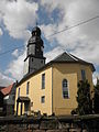
Church in Seitenroda

Half-timbered yard in Seitenroda


Individual evidence
- ^ Population of the municipalities from the Thuringian State Office for Statistics ( help on this ).
- ^ Wolfgang Kahl : First mention of Thuringian towns and villages. A manual. 5th, improved and considerably enlarged edition. Rockstuhl, Bad Langensalza 2010, ISBN 978-3-86777-202-0 , p. 262.
- ↑ Municipality of Seitenroda on the website of the administrative association Südliches Saaletal. Accessed on September 2, 2011.
Web links
Albersdorf | Altenberga | Bad Klosterlausnitz | Bibra | Bobeck | Bremsnitz | Bucha | Bürgel | Crossing the Elster | Dornburg-Camburg | Eichenberg | Eineborn | Eisenberg | Frauenprießnitz | Outdoor orla | Geisenhain | Gneus | Golmsdorf | Gosen | Graitschen at Bürgel | Greater buckedra | Grosseutersdorf | Großlöbichau | Großpürschütz | Gumperda | Hainichen | Hainspitz | Hartmannsdorf | Heathland | Hermsdorf | Hummelshain | Jenalöbnitz | Kahla | Karlsdorf | Little buckedra | Kleinebersdorf | Kleineutersdorf | Laasdorf | Lehesten | Lindig | Lippersdorf-Erdmannsdorf | Löberschütz | Mertendorf | Meusebach | Milda | Möckern | Mörsdorf | Nausnitz | Neuengönna | Oberbodnitz | Orlamünde | Ottendorf | Petersberg | Poxdorf | Rattelsdorf | Rauda | Rauschwitz | Rausdorf | Reichenbach | Reinstädt | Renthendorf | Rothenstein | Ruttersdorf-Lotschen | Scheiditz | Schkölen | Grinding trips | Schlöben | Schöngleina | Schöps | Side rod | Serba | Silbitz | Stadtroda | St. Gangloff | Sulza | Tautenburg | Tautendorf | Tautenhain | Animal snail | Tissa | Trobnitz | Trockenborn-Wolfersdorf | Unterbodnitz | Waldeck | Walpernhain | Waltersdorf | Weissbach | Weißenborn | Wichmar | Rooms | Zollnitz