
Jenalöbnitz
| coat of arms | Germany map | |
|---|---|---|

|
Coordinates: 50 ° 57 ' N , 11 ° 42' E |
|
| Basic data | ||
| State : | Thuringia | |
| County : | Saale-Holzland district | |
| Management Community : | Dornburg-Camburg | |
| Height : | 208 m above sea level NHN | |
| Area : | 3.96 km 2 | |
| Residents: | 157 (Dec. 31, 2019) | |
| Population density : | 40 inhabitants per km 2 | |
| Postal code : | 07751 | |
| Area code : | 03641 | |
| License plate : | SHK, EIS, SRO | |
| Community key : | 16 0 74 043 | |
| Address of the municipal administration: |
Dorfstrasse 8 07751 Jenalöbnitz |
|
| Website : | ||
| Mayor : | Joachim Geyer | |
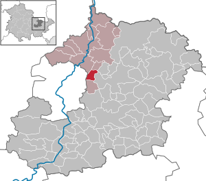
| Location of the community Jenalöbnitz in the Saale-Holzland district | ||
  |
||

Jenalöbnitz is a municipality in the north of the Saale-Holzland district and part of the Dornburg-Camburg administrative community .
geography

Adjacent communities are Golmsdorf in the north-west, Löberschütz in the north, Graitschen in the north-east, the city of Bürgel in the east, Großlöbichau in the south and the independent city of Jena in the west.
Early history
It is believed that the valley was first settled in the Stone Age . Excavations on the Old Gleisberg have found finds from around 1500 BC. BC brought to light, which are assigned to the Celts . At the same time, agricultural properties are suspected in the valley. A real village settlement probably only took place through the Teutons. From the 5th century AD, the ancestors of today's Thuringians settled on the area. However, it has not yet been proven whether there were Thuringian settlements on today's Jenalöbnitz corridor. In the immediate vicinity of the village, water was found at the Bornloch, where there was also an escape cave. After the Thuringian Empire was smashed in the 6th century, the groups living between the Saale and the Oder emigrated, and this was probably at the same time as the migrating Slavs . This process can be observed above all in the Saale area. The first inhabitants, definitely Slavic, have been handed down by documents from the imperial monasteries of Fulda and Hersfeld . Jenalöbnitz can be assumed to have come into being at this time. So far, however, it is not clear whether the name originally referred to Oberlöbnitz or Niederlöbnitz (today's Jenalöbnitz). Kirchberg Castle was first mentioned in a document in 937 . Jenalöbnitz was safely on a connecting road between the royal castles of Kirchberg and Dornburg , which ran over the Sattelpass at the rear of Jenzig . Therefore, it is not unlikely that the place already existed then.
First mention
W. Kahl reports that it was first mentioned in a document on September 6, 1185. However, the first mention of the place dates from 1220. In a document from November 9, 1220, a Bruno de Lubenescz appears as a witness. The place itself is first mentioned in a document dated March 29, 1395. The works of Gotthard Neumann and Hans-Joachim Stoll provide more precise information about the status of the archaeological investigations and date the oldest part of the tower hill castle to the colonization period. The Niederlöbnitz, which still existed at the end of the 14th century, was sold to the Brückenhofsstiftung of the city of Jena, through which the name Jena-Löbnitz prevailed in the following period. In what is now the Jenalöbnitz district, in addition to the two villages of Oberlöbnitz and Niederlöbnitz, there was also the now desolate Raßdorf or Rathsdorf. The oldest mentions of residents can be found in the local history of Jenalöbnitz.
The Church of St. Catherine dates from the 14th century.
Web links
- Website about Jenalöbnitz. Retrieved June 16, 2019 .
Individual evidence
- ^ Population of the municipalities from the Thuringian State Office for Statistics ( help on this ).
- ^ Conference - rivers and river valleys as economic and communication routes
- ^ Wolfgang Kahl : First mention of Thuringian towns and villages. A manual. 5th, improved and considerably enlarged edition. Rockstuhl, Bad Langensalza 2010, ISBN 978-3-86777-202-0 , p. 134.
- ^ Seminar for Prehistory and Early History at the FSU Jena. Retrieved June 16, 2019 .
Albersdorf | Altenberga | Bad Klosterlausnitz | Bibra | Bobeck | Bremsnitz | Bucha | Bürgel | Crossing the Elster | Dornburg-Camburg | Eichenberg | Eineborn | Eisenberg | Frauenprießnitz | Outdoor orla | Geisenhain | Gneus | Golmsdorf | Gosen | Graitschen at Bürgel | Greater buckedra | Grosseutersdorf | Großlöbichau | Großpürschütz | Gumperda | Hainichen | Hainspitz | Hartmannsdorf | Heathland | Hermsdorf | Hummelshain | Jenalöbnitz | Kahla | Karlsdorf | Little buckedra | Kleinebersdorf | Kleineutersdorf | Laasdorf | Lehesten | Lindig | Lippersdorf-Erdmannsdorf | Löberschütz | Mertendorf | Meusebach | Milda | Möckern | Mörsdorf | Nausnitz | Neuengönna | Oberbodnitz | Orlamünde | Ottendorf | Petersberg | Poxdorf | Rattelsdorf | Rauda | Rauschwitz | Rausdorf | Reichenbach | Reinstädt | Renthendorf | Rothenstein | Ruttersdorf-Lotschen | Scheiditz | Schkölen | Grinding trips | Schlöben | Schöngleina | Schöps | Side rod | Serba | Silbitz | Stadtroda | St. Gangloff | Sulza | Tautenburg | Tautendorf | Tautenhain | Animal snail | Tissa | Trobnitz | Trockenborn-Wolfersdorf | Unterbodnitz | Waldeck | Walpernhain | Waltersdorf | Weissbach | Weißenborn | Wichmar | Rooms | Zollnitz