
Meusebach
| coat of arms | Germany map | |
|---|---|---|
 Help on coat of arms |
Coordinates: 50 ° 49 ' N , 11 ° 44' E |
|
| Basic data | ||
| State : | Thuringia | |
| County : | Saale-Holzland district | |
| Management Community : | Hills / valleys | |
| Height : | 260 m above sea level NHN | |
| Area : | 6.12 km 2 | |
| Residents: | 91 (Dec. 31, 2019) | |
| Population density : | 15 inhabitants per km 2 | |
| Postal code : | 07646 | |
| Area code : | 036428 | |
| License plate : | SHK, EIS, SRO | |
| Community key : | 16 0 74 056 | |
| Address of the municipal administration: |
Dorfstrasse 27 07646 Meusebach |
|
| Website : | ||
| Mayor : | Jürgen Holtz | |
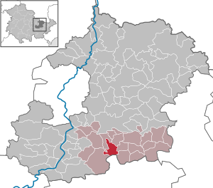
| Location of the municipality of Meusebach in the Saale-Holzland district | ||
  |
||

Meusebach is a municipality in the south of the Saale-Holzland district and part of the Hügelland / Täler administrative community . The place Meusebach has the nickname "village without sparrows". The name is based on a legend in which two sparrows are first brought to the village as a wedding present. They multiply so strongly that they threaten the harvest by pecking away the seeds . A hunter then freed the village from the sparrows by sowing two truckloads of spruce and beech seeds, by the same number of sparrows banished be.
geography
Meusebach is located in a winding side valley, with only one access road.

history
The place was first mentioned in a document on December 8, 1271.
In the Middle Ages, Meusebach owned a fortified replacement living space in the courtyard of a church, about 3 km southeast of today's location. The desert church was surrounded by a rampart and a moat. Remnants of the wall are still present within the wall, and a spring version is still recognizable.
Attractions
The sights in and near Meusebach are well signposted and instructively presented on display boards
- Preserved and restored half-timbered houses
- Old forester's house : on the foundations of the headquarters of the von Meusebach family. From 1543 the official seat of the electoral game masters. Burned down in 1547, current construction from 1657. Until 1952, district forester's house, then used by the community for cultural purposes. Privately owned since 1998 and well renovated.
- 250-year-old tulip tree : in front of the south gable of the old forester's house. It is 22 m high and is in full bloom at the beginning of June. Natural monument.
- The French cross near Meusebach: in memory of a French soldier who is said to have been slain by the villagers so that he could not betray their hidden village to his pillaging comrades
- The wild master stone
- Industrial monument charcoal burning near Meusebach: until the fall of the Wall , charcoal was produced here for export to the West
- Reconstructed medieval fortified village near Meusebach (operated by the Landsknechtsverein Verlorenes Fähnlein eV)
- Albrechts oak north-west of the village on the access road: natural monument, planted in 1712 in honor of Christian Albrecht von Meusebach
- Desert Church : see above under History
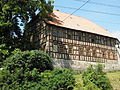
Old forester's house from 1657
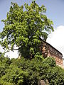
Tulip tree at the forester's house

French cross
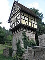
Fortified "medieval village" near Meusebach


Individual evidence
- ^ Population of the municipalities from the Thuringian State Office for Statistics ( help on this ).
- ↑ Kurt Greß: The sparrow ban in Meusebach. Wooden land sagas 1898 . Retrieved December 21, 2017
- ^ Wolfgang Kahl : First mention of Thuringian towns and villages. A manual. 5th, improved and considerably enlarged edition. Rockstuhl, Bad Langensalza 2010, ISBN 978-3-86777-202-0 , p. 41.
- ↑ Sven Ostritz (Ed.): Saale-Holzland-Kreis, Ost (= Archaeological Hiking Guide Thuringia. H. 9). Beier & Beran, Langenweißbach 2007, ISBN 978-3-937517-51-3 , p. 117.
Web links
Albersdorf | Altenberga | Bad Klosterlausnitz | Bibra | Bobeck | Bremsnitz | Bucha | Bürgel | Crossing the Elster | Dornburg-Camburg | Eichenberg | Eineborn | Eisenberg | Frauenprießnitz | Outdoor orla | Geisenhain | Gneus | Golmsdorf | Gosen | Graitschen at Bürgel | Greater buckedra | Grosseutersdorf | Großlöbichau | Großpürschütz | Gumperda | Hainichen | Hainspitz | Hartmannsdorf | Heathland | Hermsdorf | Hummelshain | Jenalöbnitz | Kahla | Karlsdorf | Little buckedra | Kleinebersdorf | Kleineutersdorf | Laasdorf | Lehesten | Lindig | Lippersdorf-Erdmannsdorf | Löberschütz | Mertendorf | Meusebach | Milda | Möckern | Mörsdorf | Nausnitz | Neuengönna | Oberbodnitz | Orlamünde | Ottendorf | Petersberg | Poxdorf | Rattelsdorf | Rauda | Rauschwitz | Rausdorf | Reichenbach | Reinstädt | Renthendorf | Rothenstein | Ruttersdorf-Lotschen | Scheiditz | Schkölen | Grinding trips | Schlöben | Schöngleina | Schöps | Side rod | Serba | Silbitz | Stadtroda | St. Gangloff | Sulza | Tautenburg | Tautendorf | Tautenhain | Animal snail | Tissa | Trobnitz | Trockenborn-Wolfersdorf | Unterbodnitz | Waldeck | Walpernhain | Waltersdorf | Weissbach | Weißenborn | Wichmar | Rooms | Zollnitz