
Lippersdorf-Erdmannsdorf
| coat of arms | Germany map | |
|---|---|---|
 Help on coat of arms |
Coordinates: 50 ° 50 ′ N , 11 ° 48 ′ E |
|
| Basic data | ||
| State : | Thuringia | |
| County : | Saale-Holzland district | |
| Management Community : | Hills / valleys | |
| Height : | 230 m above sea level NHN | |
| Area : | 9.96 km 2 | |
| Residents: | 439 (Dec. 31, 2019) | |
| Population density : | 44 inhabitants per km 2 | |
| Postal code : | 07646 | |
| Area code : | 036426 | |
| License plate : | SHK, EIS, SRO | |
| Community key : | 16 0 74 053 | |
| Community structure: | 2 districts | |
| Address of the municipal administration: |
Lindenstrasse 30 07646 Lippersdorf-Erdmannsdorf |
|
| Website : | ||
| Mayor : | Jochen Suess | |
| Location of the community Lippersdorf-Erdmannsdorf in the Saale-Holzland district | ||
  |
||

Lippersdorf-Erdmannsdorf is a municipality in the southeast of the Saale-Holzland district and part of the Hügelland / Täler administrative community .
geography
The community is located as a two- row village in the Roda valley and is one of the so-called valley villages . The two streets on which the corridors and properties are located run parallel to the creek flowing in the center of the village. The neighboring villages are Ottendorf about 2 km east, Weißbach about 2 km south, the district Erdmannsdorf about 1 km west. The state road L 1062 runs through the village, which joins the state road L 1073 near Tautendorf near the eastbound A 9 and leads to Kahla in the west .
history
The establishment of Lippersdorf took place probably in the 12th century on clearing land by German settlers, whose leader was probably Liebrecht. According to Wolfgang Kahl, the first documented mention of Lippersdorf was on December 29, 1293 and that of Erdmannsdorf on March 31, 1206. However, the Hügelland-Täler administrative community noted on its website that the original document was not found during a search in the Thuringian main state archive and that the first verifiable written mention of Lippersdorf was found in a document by Friedrich des Strengen from 1350 in the Altenburg State Archives. In 1543 the brothers Apel and Kunz von Meusebach bought the villages and manors Lippersdorf and Erdmannsdorf. When the family died out in 1753, the manors fell back to the sovereignty of Saxony-Gotha-Altenburg, and in 1825 to the Duchy of Saxony-Altenburg.
During the GDR era, the nationally owned combine wholesale WtB built and maintained the “ Philipp Müller ” holiday camp in Lippersdorf for the children of its employees .
Attractions
The origins of the church are in the 12th / 13th centuries. Century. The church of St. Nicolai ( Lage → ), patron saint of boatmen, hikers and carters, is mentioned for the first time in the oldest book of the parish, the church accounting book from the years 1541–1663. Structurally, little is left of that old church. The current church was built between 1714 and 1719, the current steeple in 1766.
Pictures from Lippersdorf and Erdmannsdorf 2013
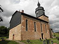
St. Nicolai Church in Lippersdorf

Church in Erdmannsdorf
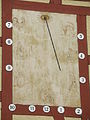
Sundial at the parish hall in Erdmannsdorf
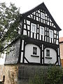
Half-timbered house in Lippersdorf


literature
Leaflet "St. Nicolai Lippersdorf" of the parish (copy 2013 in the church)
Web links
Individual evidence
- ^ Population of the municipalities from the Thuringian State Office for Statistics ( help on this ).
- ^ Wolfgang Kahl: First mention of Thuringian cities and villages , Rockstuhl Publishing House, Bad-Langensalza 2010. ISBN 978-3-86777-202-0
- ↑ Note about the first mention on the website of the administrative community
- ↑ Information on the website of the administrative association
Albersdorf | Altenberga | Bad Klosterlausnitz | Bibra | Bobeck | Bremsnitz | Bucha | Bürgel | Crossing the Elster | Dornburg-Camburg | Eichenberg | Eineborn | Eisenberg | Frauenprießnitz | Outdoor orla | Geisenhain | Gneus | Golmsdorf | Gosen | Graitschen at Bürgel | Greater buckedra | Grosseutersdorf | Großlöbichau | Großpürschütz | Gumperda | Hainichen | Hainspitz | Hartmannsdorf | Heathland | Hermsdorf | Hummelshain | Jenalöbnitz | Kahla | Karlsdorf | Little buckedra | Kleinebersdorf | Kleineutersdorf | Laasdorf | Lehesten | Lindig | Lippersdorf-Erdmannsdorf | Löberschütz | Mertendorf | Meusebach | Milda | Möckern | Mörsdorf | Nausnitz | Neuengönna | Oberbodnitz | Orlamünde | Ottendorf | Petersberg | Poxdorf | Rattelsdorf | Rauda | Rauschwitz | Rausdorf | Reichenbach | Reinstädt | Renthendorf | Rothenstein | Ruttersdorf-Lotschen | Scheiditz | Schkölen | Grinding trips | Schlöben | Schöngleina | Schöps | Side rod | Serba | Silbitz | Stadtroda | St. Gangloff | Sulza | Tautenburg | Tautendorf | Tautenhain | Animal snail | Tissa | Trobnitz | Trockenborn-Wolfersdorf | Unterbodnitz | Waldeck | Walpernhain | Waltersdorf | Weissbach | Weißenborn | Wichmar | Rooms | Zollnitz