
Zollnitz
| coat of arms | Germany map | |
|---|---|---|

|
Coordinates: 50 ° 52 ' N , 11 ° 39' E |
|
| Basic data | ||
| State : | Thuringia | |
| County : | Saale-Holzland district | |
| Management Community : | Southern Saale Valley | |
| Height : | 229 m above sea level NHN | |
| Area : | 4.2 km 2 | |
| Residents: | 892 (Dec. 31, 2019) | |
| Population density : | 212 inhabitants per km 2 | |
| Postal code : | 07751 | |
| Area code : | 03641 | |
| License plate : | SHK, EIS, SRO | |
| Community key : | 16 0 74 114 | |
| LOCODE : | DE ZNZ | |
| Association administration address: | Bahnhofstrasse 23 07768 Kahla |
|
| Website : | ||
| Mayoress : | Ingrid Helmke | |
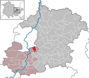
| Location of the municipality of Zöllnitz in the Saale-Holzland district | ||
  |
||

Zöllnitz is a municipality in the south of the Saale-Holzland district and part of the administrative community Südliches Saaletal .
geography
Zöllnitz is located directly south of the independent city of Jena . In the east it is surrounded by the municipality of Laasdorf , in the west by the municipality of Sulza .
history
The first evidence of the existence comes from the year 1343. In this document the purchase of a vineyard near Beutnitz by the pleban Heinrich von “Zilnicz” is certified. The oldest tradition from court owners comes from the period 1421–1425.
→ See Zöllnitz village church
economy
Zöllnitz is home to some smaller industrial areas in the north and west of the municipality. In the west one finds z. B. a branch of the furniture chain Roller, in the northern part next to the FairHotel also a car dealership and some small businesses.
traffic
Zöllnitz is connected to bus lines 427 and 472, which run from Hermsdorf via Stadtroda to the center of Jena. The Neue Schenke station is on the Weimar – Gera railway line on the northeastern municipal boundary . It connects Zöllnitz to the regional rail traffic from Gera via Jena to Erfurt.
The route of the A4 motorway runs between Zöllnitz and Neulobeda and can be reached via the nearby Jena-Zentrum junction .
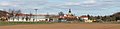
Place view

Street view
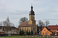
church

Neue Schenke station (2017)


people
Born here
- Louis Schmeisser (1848–1917), weapons designer
Web links
- Official website
- Administrative community Südliches Saaletal
- Link catalog on the subject of Zöllnitz at curlie.org (formerly DMOZ )
Individual evidence
- ^ Population of the municipalities from the Thuringian State Office for Statistics ( help on this ).
- ^ Andrei Zahn: The inhabitants of the offices of Burgau, Camburg and Dornburg. A prayer register from around 1421–1425 (= AMF series of publications. 55, ZDB -ID 2380765-9 ). Printed as a manuscript. Working Group for Central German Family Research, Mannheim 1998.
Albersdorf | Altenberga | Bad Klosterlausnitz | Bibra | Bobeck | Bremsnitz | Bucha | Bürgel | Crossing the Elster | Dornburg-Camburg | Eichenberg | Eineborn | Eisenberg | Frauenprießnitz | Outdoor orla | Geisenhain | Gneus | Golmsdorf | Gosen | Graitschen at Bürgel | Greater buckedra | Grosseutersdorf | Großlöbichau | Großpürschütz | Gumperda | Hainichen | Hainspitz | Hartmannsdorf | Heathland | Hermsdorf | Hummelshain | Jenalöbnitz | Kahla | Karlsdorf | Little buckedra | Kleinebersdorf | Kleineutersdorf | Laasdorf | Lehesten | Lindig | Lippersdorf-Erdmannsdorf | Löberschütz | Mertendorf | Meusebach | Milda | Möckern | Mörsdorf | Nausnitz | Neuengönna | Oberbodnitz | Orlamünde | Ottendorf | Petersberg | Poxdorf | Rattelsdorf | Rauda | Rauschwitz | Rausdorf | Reichenbach | Reinstädt | Renthendorf | Rothenstein | Ruttersdorf-Lotschen | Scheiditz | Schkölen | Grinding trips | Schlöben | Schöngleina | Schöps | Side rod | Serba | Silbitz | Stadtroda | St. Gangloff | Sulza | Tautenburg | Tautendorf | Tautenhain | Animal snail | Tissa | Trobnitz | Trockenborn-Wolfersdorf | Unterbodnitz | Waldeck | Walpernhain | Waltersdorf | Weissbach | Weißenborn | Wichmar | Rooms | Zollnitz