
Frauenprießnitz
| coat of arms | Germany map | |
|---|---|---|
 Help on coat of arms |
Coordinates: 51 ° 1 ′ N , 11 ° 44 ′ E |
|
| Basic data | ||
| State : | Thuringia | |
| County : | Saale-Holzland district | |
| Management Community : | Dornburg-Camburg | |
| Height : | 320 m above sea level NHN | |
| Area : | 18.47 km 2 | |
| Residents: | 834 (Dec. 31, 2019) | |
| Population density : | 45 inhabitants per km 2 | |
| Postal code : | 07774 | |
| Area code : | 036421 | |
| License plate : | SHK, EIS, SRO | |
| Community key : | 16 0 74 019 | |
| Community structure: | 4 districts | |
| Address of the municipal administration: |
Karl-Marx-Strasse 22 07774 Frauenprießnitz |
|
| Website : | ||
| Mayor : | Jürgen Hofmann (since July 1, 2010) | |
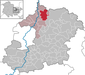
| Location of the community of Frauenprießnitz in the Saale-Holzland district | ||
  |
||

Frauenprießnitz is a municipality in the northeast of the Saale-Holzland district in Thuringia and a member of the Dornburg-Camburg administrative community .
geography
Frauenprießnitz is located northeast of Jena . Districts are Kleinprießnitz , Rodameuschel and Schleuskau .
history
The mention of Hugo von Prießnitz in April 1144 was previously associated with the first mention of both Frauenprießnitz and Prießnitz near Naumburg. Since this document has now been identified as a forgery, it is no longer the first mention. Thus the currently oldest known mention is from 1166. The place name Frauenprießnitz indicates a Slavic foundation. It means “Birkendorf”, the ending “nitz” is translated as Aue. The place got its name from the local nunnery Frauenprießnitz . The tradition that the nunnery emerged from a separation from the Moritz monastery in Naumburg is no longer tenable today.
From 1427 the Tautenburg taverns , a line of taverns from Vargula, were masters of the place . Gift Rudolf the Elder received the place Frauenprießnitz as a fief in 1440. In 1470 the family crypt of the taverns was built in the Cistercian nunnery. The place developed into a small residence in the following period. Since the division of Leipzig in 1485, the dominions of Frauenprießnitz and Tautenburg belong to the Albertine (ducal) line of Saxony, whereby the taverns were feudal men of the duke. From 1494 the name "Frauenprießnitz" is applied to the place. The convent dissolved in the 1520s and, despite efforts, could not be revived until the Reformation in 1539.
Since the Wittenberg surrender in 1547, Frauenprießnitz belonged to the Albertine electorate of Saxony with the rule of Tautenburg . Under Schenk Burkhard, Frauenprießnitz achieved the greatest importance during the rule of the Schenken von Tautenburg. For the construction of the Frauenprießnitz Castle , he ordered the demolition of the destroyed monastery between 1602 and 1605, the building of which was used as a quarry. After his death in 1605, his widow completed the new palace by 1608. During the Thirty Years War , the castle, church and village were cremated in 1638. The incumbent Schenk Christian therefore moved to Tautenburg and died in 1640 as the last offspring of the Thuringian line of Schenken von Tautenburg.
The Elector Johann Georg I of Saxony had given the fallen fiefdom of the Tautenburg lordship with Frauenprießnitz and Niedertrebra to one third each as a new fiefdom in 1640 to those of Werthern , von Döring and von Taube , to whom he had previously assured in writing that they were entitled to it. In 1652 the Saxon elector bought back the Tautenburg estate with Frauenprießnitz from them. He had the inherited ruins rebuilt as a Renaissance castle and set up a domain. The business of the princely chamber estate was managed by an administrator until 1703. In 1720 the former royal privy councilor Erasmus von Maltitz took over the chamber property as a tenant.
Frauenprießnitz belonged since 1652 to the Office Tautenburg which the Albertine 1657 Sekundogenitur -Fürstentum Saxe-Zeitz was sold and in 1718 fell back to the Electorate of Saxony. In 1776 the judicial office was moved from Tautenburg Castle to Frauenprießnitz. The rent office was housed in Frauenprießnitz Castle. In 1780, Tautenburg Castle was demolished for the construction of the new justice and rent office in Frauenprießnitz and the building materials were used there. With the appointment of the Electorate of Saxony to the Kingdom , Frauenprießnitz belonged to the Kingdom of Saxony from 1806 .
With the cession of the royal Saxon office of Tautenburg to Prussia at the Congress of Vienna in 1815 , the office was dissolved. In June 1815 Frauenprießnitz came with the main part of the former office to the Grand Duchy of Saxony-Weimar-Eisenach and in 1822 was affiliated to the Bürgel office. In 1850 the place came to the administrative district Weimar II (from 1868: administrative district Apolda ) of the Grand Duchy. Frauenprießnitz has been part of the Free State of Thuringia since 1920.
After the Second World War , the order 209 of the SMAD ordered the demolition of the castle. Only the main building of the castle, in which a machine-tractor station (MTS) was housed, escaped the demolition measures in 1948 . Everything else - including the beautiful Renaissance-style domain building - was removed and the complex lost its special character.
Personalities
- Georg Berlich (1600–1671), Protestant theologian
- Burchard Berlich (1603–1670), lawyer, professor of law in Jena, civil servant in Dresden
- Frank Mantek (* 1959), national weightlifting coach
- Mario Kanopa (* 1978), footballer
Development of the population
(each December 31st)
|
|
|
|
|
- Data source: Thuringian State Office for Statistics
Attractions
- The former monastery church of St. Mauritius has been reconstructed, has had a new organ since 2009 , built by the local master carpenter Schenke, and is used for musical events such as organ concerts and choir performances. Today it serves as a place of worship for the local Evangelical Lutheran parish.
- Preserved main building of Frauenprießnitz Castle from the 18th century
- In the village, opposite the village pond, there is a stone cross group made of five stones. It was moved there in 1972. Before that, it stood at the fork in the road to Thierschneck and Wetzdorf, where it was relocated during the separation from the Hessenburg parcel. Originally the stones are said to have stood on different locations.

Former rent office
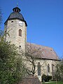
Village church (former monastery)

Interior of the church


Individual evidence
- ^ Population of the municipalities from the Thuringian State Office for Statistics ( help on this ).
- ↑ Thank God Immanuel Merkel: Earth description of the Kingdom of Saxony. Volume 8. 3rd edition. Mostly completely reworked by Karl August Engelhardt from handwritten sources . Barth, Dresden 1811, p. 169 f.
- ^ Karlheinz Blaschke , Uwe Ulrich Jäschke : Kursächsischer Ämteratlas 1790. Scale approx. 1: 200000. Gumnior, Chemnitz 2009, ISBN 978-3-937386-14-0 , p. 34 f.
- ^ Anton Friderich Büsching : New description of the earth. Part 3, Volume 2: Which contains the Swabian, Bavarian, Franconian and Upper Saxon districts. 6th edition. Bohn, Hamburg 1778, pp. 707 and 817 .
- ^ Johann Ludwig Klüber : State Archives of the German Confederation. Volume 1, Issue 2. JJ Palm and Ernst Enke, Erlangen 1816, p. 373 .
- ↑ Bürgel at www.geo.viaregia.org
- ↑ Geographical overview of the Saxon-Ernestine, Schwarzburg, Reussian and adjacent lands. Perthes, Gotha 1826, p. 53 .
- ^ The places of the administrative district Apolda in the municipality register 1900 .
- ↑ Sven Ostritz (Ed.): Saale-Holzland-Kreis, Ost (= Archaeological Hiking Guide Thuringia. 9). Beier & Beran, Langenweißbach 2007, ISBN 978-3-937517-51-3 , pp. 25-26.
Web links
Albersdorf | Altenberga | Bad Klosterlausnitz | Bibra | Bobeck | Bremsnitz | Bucha | Bürgel | Crossing the Elster | Dornburg-Camburg | Eichenberg | Eineborn | Eisenberg | Frauenprießnitz | Outdoor orla | Geisenhain | Gneus | Golmsdorf | Gosen | Graitschen at Bürgel | Greater buckedra | Grosseutersdorf | Großlöbichau | Großpürschütz | Gumperda | Hainichen | Hainspitz | Hartmannsdorf | Heathland | Hermsdorf | Hummelshain | Jenalöbnitz | Kahla | Karlsdorf | Little buckedra | Kleinebersdorf | Kleineutersdorf | Laasdorf | Lehesten | Lindig | Lippersdorf-Erdmannsdorf | Löberschütz | Mertendorf | Meusebach | Milda | Möckern | Mörsdorf | Nausnitz | Neuengönna | Oberbodnitz | Orlamünde | Ottendorf | Petersberg | Poxdorf | Rattelsdorf | Rauda | Rauschwitz | Rausdorf | Reichenbach | Reinstädt | Renthendorf | Rothenstein | Ruttersdorf-Lotschen | Scheiditz | Schkölen | Grinding trips | Schlöben | Schöngleina | Schöps | Side rod | Serba | Silbitz | Stadtroda | St. Gangloff | Sulza | Tautenburg | Tautendorf | Tautenhain | Animal snail | Tissa | Trobnitz | Trockenborn-Wolfersdorf | Unterbodnitz | Waldeck | Walpernhain | Waltersdorf | Weissbach | Weißenborn | Wichmar | Rooms | Zollnitz