
Milda
| coat of arms | Germany map | |
|---|---|---|

|
Coordinates: 50 ° 51 ' N , 11 ° 28' E |
|
| Basic data | ||
| State : | Thuringia | |
| County : | Saale-Holzland district | |
| Management Community : | Southern Saale Valley | |
| Height : | 405 m above sea level NHN | |
| Area : | 22.05 km 2 | |
| Residents: | 742 (Dec. 31, 2019) | |
| Population density : | 34 inhabitants per km 2 | |
| Postal code : | 07751 | |
| Area code : | 036422 | |
| License plate : | SHK, EIS, SRO | |
| Community key : | 16 0 74 057 | |
| Association administration address: | Bahnhofstrasse 23 07768 Kahla |
|
| Website : | ||
| Mayor : | Albert Weiler | |
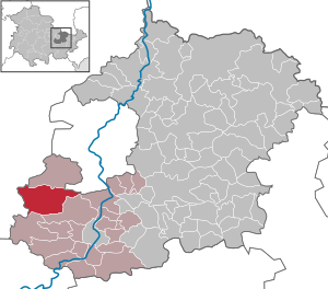
| Location of the municipality of Milda in the Saale-Holzland district | ||
  |
||

Milda is a municipality in the south of the Saale-Holzland district and part of the administrative association Südliches Saaletal . The municipality of Milda includes Milda, Zimmritz , Dürrengleina , Kleinkröbitz and Großkröbitz , Rodias and Plinz .
geography
Milda is the second westernmost place in the Saale-Holzland district. It is 30 kilometers as the crow flies to the district town of Eisenberg . The demarcation lies on a slightly undulating plateau on shell limestone . The arable sites are mostly far from groundwater. The Zettelwitz desert lies in the municipal area .
history

The place name is probably due to the fact that the village is on the plateau, but in a hollow in the headwaters of the Leutra . That would make it of Germanic origin.
The romantic Leutragraben stretches from the village to the former A4 motorway (section Jena-Göschwitz - Schorba). From here the motorway to Maua ran parallel to the Leutra. Since the Jagdberg tunnel went into operation , this section is currently being renatured again. In Maua the Leutra flows into the Saale .
The place was mentioned in documents under the names Immelden (around 1070), Muldau or Muldauw (around 1200), Mylda (1534), Mülda (1750), Milda (1761).
The place was possibly Sorbian or Slavic settled, the place name Shorba and numerous settlement names ending in -itz as well as a Slavic grave discovered in 1932 indicate this .
The place was round with only one entrance between the church and the rectory. Milda belonged as an exclave to the rulership of Kranichfeld , which had changing owners (to Gotha from 1663, to Meiningen from 1826) and was completely surrounded by Weimar and Altenburg.
An outbreak of the plague claimed 99 deaths in 1564, which corresponded to about half of the population. During the Thirty Years' War , on May 6, 1639, the farmers clashed with the Swedes, hence the field name "Mordgraben" south of the village. On September 10, 1793, a fire destroyed almost the entire village.
In April 1945 the place was occupied by the US Army , which was replaced by the Red Army in early July 1945 . From 1952 on, agriculture was forcibly collectivized in the previous farming village .
Population development
In 1693 Milda had 232 inhabitants, including some bearers of the rare name Kornarius, descendants of the scholar Janus Cornarius , who died in nearby Jena in 1558 . Further development of the population:
| year | 1728 | 1843 | 1895 | 1910 | 1936 | 1994 | 1999 | 2005 | 2010 | 2015 |
| Residents | 218 | 231 | 289 | 303 | 282 | 726 | 856 | 828 | 810 | 748 |
politics
Municipal council
The municipal council consists of eight members. Since the local elections on May 25, 2014 , the seats have been distributed as follows (the respective percentage of votes in brackets):
mayor
As elected mayors emerged from the elections of recent years:
- June 12, 1994: Silvia Voigt (CDU) with 82.3% (mayor in )
- June 13, 1999: Roland Dick (CDU) with 40.0%
- June 27, 2004: Albert Helmut Weiler (CDU) with 47.6%
- June 6, 2010: Albert Helmut Weiler (CDU) with 99.5%
- June 5, 2016: Albert Helmut Weiler (CDU) with 98.1%
coat of arms
Description of the coat of arms : “Split of gold and green; a green deciduous tree in front, a golden crane in the back. "
Attractions


- The oldest house is the rectory ( location → ) from 1555, which was the only one (besides five barns) to survive the fire of 1793, but it was in a very poor condition. The rectory was renovated in 2016 and 2017, and the rooms are now partially used by the local kindergarten.
- The St. Jakobus Church , consecrated to St. Jacob , was erected after the fire in 1793 on the site of the previous building with the preservation of its walls from 1794, the consecration was on the 1st Advent in 1796. The church was laid out as a fortified church , the churchyard was strong Walls surrounded by four corner towers. The southeastern stump of the tower and a large part of the 0.90 m thick and up to three meters high wall with paired loopholes that made it possible to shoot crosswise have been preserved. The churchyard fortification connected to an old village gate. The ringing originally comprised three bells from the Ulrich Brothers from Apolda (1796). The two larger bells had to be given in during the First World War . In the 1920s, two new bells were purchased, which had to be returned during World War II . Only in 2017, following a fundraising campaign, the missing two bells were replaced based on the historical model (cast on July 7, 2017 by the Bachert bell foundry in Karlsruhe). A special feature of the outer building is a bricked stone with the inscription "T Hans Merten 1572" right next to the main entrance and a stone with two heads and craftsmen's insignia just below the northern roof. It is no longer possible to conclusively clarify whether these stones come from the previous building or from another source. The church was tiled until 1869, then - including the upper floor of the tower - with slate. In 2003 the tower ball was renewed, 2007-2011 a renovation of the roof beams took place. From the facilities in 1870 added - - two-storey lofts and located at the level of the first gallery are pulpit worth mentioning. The organ by Adam Eifert from Stadtilm (around 1885) with 13 stops, two manuals and a pedal replaced an older one built by Johann Stephan Schmaltz's stepson , Ludwig Wilhelm Hähner from Arnstadt . It is uncertain whether Eifert perhaps only rebuilt the Hahner organ.
- On both sides of the church entrance there are memorial plaques with the names of the soldiers who died and went missing in both world wars.
- Village square with stately oaks and linden trees
- Large pond east of the fortified churchyard, which contributed to its protection. The former pond, which was close to today's road, has meanwhile been filled in. In the meantime, a new pond has been created as part of a compensatory measure for the expansion of the neighboring federal motorway, which is a few meters further north and thus further away from the road. On the area of the former pond there is now a children's playground, which is currently (as of September 2019) being renovated.

Church: historical photo from 1966 (the pond was filled in a little later)

Church and rectory (right)

Church: galleries and pulpit (condition of the choir until 2014)

Church: organ

Church: weather vane from 1795 (with addition from 1882)

Corner tower in the defensive wall of the church in Milda

Churchyard wall with loopholes in Milda

Former rectory in Milda (courtyard side, 2012)


traffic
Milda is a few kilometers away from the federal motorway 4 running north (junction 52, Bucha). Milda is connected to this by state road 2309 , which was fundamentally rebuilt in 2007. Further streets go in the directions of Kahla and Blankenhain .
Web links
Individual evidence
- ^ Population of the municipalities from the Thuringian State Office for Statistics ( help on this ).
- ↑ Elections in the Free State of Thuringia - 2014 municipal council election: Milda , accessed on September 9, 2018
Albersdorf | Altenberga | Bad Klosterlausnitz | Bibra | Bobeck | Bremsnitz | Bucha | Bürgel | Crossing the Elster | Dornburg-Camburg | Eichenberg | Eineborn | Eisenberg | Frauenprießnitz | Outdoor orla | Geisenhain | Gneus | Golmsdorf | Gosen | Graitschen at Bürgel | Greater buckedra | Grosseutersdorf | Großlöbichau | Großpürschütz | Gumperda | Hainichen | Hainspitz | Hartmannsdorf | Heathland | Hermsdorf | Hummelshain | Jenalöbnitz | Kahla | Karlsdorf | Little buckedra | Kleinebersdorf | Kleineutersdorf | Laasdorf | Lehesten | Lindig | Lippersdorf-Erdmannsdorf | Löberschütz | Mertendorf | Meusebach | Milda | Möckern | Mörsdorf | Nausnitz | Neuengönna | Oberbodnitz | Orlamünde | Ottendorf | Petersberg | Poxdorf | Rattelsdorf | Rauda | Rauschwitz | Rausdorf | Reichenbach | Reinstädt | Renthendorf | Rothenstein | Ruttersdorf-Lotschen | Scheiditz | Schkölen | Grinding trips | Schlöben | Schöngleina | Schöps | Side rod | Serba | Silbitz | Stadtroda | St. Gangloff | Sulza | Tautenburg | Tautendorf | Tautenhain | Animal snail | Tissa | Trobnitz | Trockenborn-Wolfersdorf | Unterbodnitz | Waldeck | Walpernhain | Waltersdorf | Weissbach | Weißenborn | Wichmar | Rooms | Zollnitz