
Trockenborn-Wolfersdorf
| coat of arms | Germany map | |
|---|---|---|
 Help on coat of arms |
Coordinates: 50 ° 47 ' N , 11 ° 42' E |
|
| Basic data | ||
| State : | Thuringia | |
| County : | Saale-Holzland district | |
| Management Community : | Hills / valleys | |
| Height : | 300 m above sea level NHN | |
| Area : | 18.79 km 2 | |
| Residents: | 591 (Dec. 31, 2019) | |
| Population density : | 31 inhabitants per km 2 | |
| Postal code : | 07646 | |
| Area code : | 036428 | |
| License plate : | SHK, EIS, SRO | |
| Community key : | 16 0 74 102 | |
| Community structure: | 2 districts | |
| Association administration address: | Pfarrwinkel 10 07646 Tröbnitz |
|
| Website : | ||
| Mayor : | Dieter Hoog | |
| Location of the municipality of Trockenborn-Wolfersdorf in the Saale-Holzland district | ||
  |
||

Trockenborn-Wolfersdorf is a municipality in the south of the Saale-Holzland district in Thuringia and part of the Hügelland / Täler administrative community .
location
The municipality of Trockenborn-Wolfersdorf is located northwest of Neustadt an der Orla , east of Kahla and south of Stadtroda on the state roads 1077 and 1111 in a local forest area on the Ilm-Saale-Platte . There is the headwaters of the Schüsselbach, Grünbach, Zippenbach and the Rotehofbach , which flows into the Roda near Geisenhain .
history
In 1457 Trockenborn and on February 18, 1414 Wolfersdorf were first mentioned in a document. The history of the place was significantly influenced by the forest, water and game. Humans used the natural sources and built their dwellings according to their needs. Examples are the houses in the village and the “Happy Return” hunting lodge. Tourists and those looking for relaxation use the unique in the surrounding area.
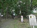
Attractions
- Hunting lodge "Fröhliche Wiederkunft" , Wolfersdorf (built 1548–1551, rebuilt in the 19th century)
- The grave of Duke Ernst II of Saxony-Altenburg (1871–1955), south of the road to the hunting lodge
- The Rieseneck hunting grounds and the Herzogsstuhl
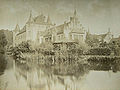
Castle "Happy Return" before 1870 from the west
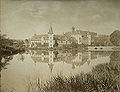
Castle "Happy Return" before 1870 from the east
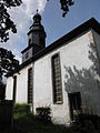
Marienkirche in Trockenborn
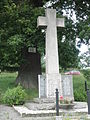
War memorial in front of the Luther Oak
the ducal graves in Trockenborn


literature
- Scheidig, Dieter: The grave of Duke Ernst von Sachsen-Altenburg in Trockenborn-Wolfersdorf, in: Rudolstädter Heimathefte, 2006 (52), issue 9/10, pp. 223–224.
Individual evidence
- ^ Population of the municipalities from the Thuringian State Office for Statistics ( help on this ).
- ↑ http://www.wahlen.thueringen.de/datenbank/wahl1/wahl.asp?wahlart=GW&wjahr=2009&habenErg=GEM&wknr=074&gemnr=74102
- ↑ http://www.wahlen.thueringen.de/datenbank/wahl1/wahl.asp?wahlart=GW&wjahr=2004&habenErg=GEM&wknr=074&gemnr=74102
- ↑ Wolfgang Kahl : First mention of Thuringian cities and villages , Rockstuhl Verlag, Bad-Langensalza, 2010, ISBN 978-3-86777-202-0 , pp. 289 and 319
Web links
Albersdorf | Altenberga | Bad Klosterlausnitz | Bibra | Bobeck | Bremsnitz | Bucha | Bürgel | Crossing the Elster | Dornburg-Camburg | Eichenberg | Eineborn | Eisenberg | Frauenprießnitz | Outdoor orla | Geisenhain | Gneus | Golmsdorf | Gosen | Graitschen at Bürgel | Greater buckedra | Grosseutersdorf | Großlöbichau | Großpürschütz | Gumperda | Hainichen | Hainspitz | Hartmannsdorf | Heathland | Hermsdorf | Hummelshain | Jenalöbnitz | Kahla | Karlsdorf | Little buckedra | Kleinebersdorf | Kleineutersdorf | Laasdorf | Lehesten | Lindig | Lippersdorf-Erdmannsdorf | Löberschütz | Mertendorf | Meusebach | Milda | Möckern | Mörsdorf | Nausnitz | Neuengönna | Oberbodnitz | Orlamünde | Ottendorf | Petersberg | Poxdorf | Rattelsdorf | Rauda | Rauschwitz | Rausdorf | Reichenbach | Reinstädt | Renthendorf | Rothenstein | Ruttersdorf-Lotschen | Scheiditz | Schkölen | Grinding trips | Schlöben | Schöngleina | Schöps | Side rod | Serba | Silbitz | Stadtroda | St. Gangloff | Sulza | Tautenburg | Tautendorf | Tautenhain | Animal snail | Tissa | Trobnitz | Trockenborn-Wolfersdorf | Unterbodnitz | Waldeck | Walpernhain | Waltersdorf | Weissbach | Weißenborn | Wichmar | Rooms | Zollnitz