
Sulza
| coat of arms | Germany map | |
|---|---|---|

|
Coordinates: 50 ° 52 ' N , 11 ° 37' E |
|
| Basic data | ||
| State : | Thuringia | |
| County : | Saale-Holzland district | |
| Management Community : | Southern Saale Valley | |
| Height : | 212 m above sea level NHN | |
| Area : | 3.97 km 2 | |
| Residents: | 274 (Dec. 31, 2019) | |
| Population density : | 69 inhabitants per km 2 | |
| Postal code : | 07751 | |
| Area code : | 03641 | |
| License plate : | SHK, EIS, SRO | |
| Community key : | 16 0 74 095 | |
| Association administration address: | Bahnhofstrasse 23 07768 Kahla |
|
| Website : | ||
| Mayor : | Alf Dalibor | |
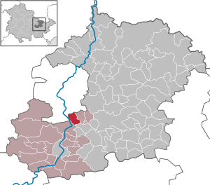
| Location of the community Sulza in the Saale-Holzland district | ||
  |
||

Sulza is a municipality in the south of the Saale-Holzland district and part of the administrative association Südliches Saaletal . The districts of Rutha and Schiebelau belong to Sulza .
location

Sulza is located south of the city of Jena on a higher floor east of the Saaleniederung . The local area is surrounded by forest. The traffic connection is given.
history
Sulza was first mentioned in documents in 1349/50. Since the middle of the 12th century the area belonged to the dominion of the Lords of Lobdeburg. Sulza et al. a. to the Puster family. The Wettins appeared as feudal lords in the 14th century , who incorporated Sulza with changing legal claims, partly into the Leuchtenburg and partly into the Burgau. One of the oldest registers of the farm owners dates from 1421–1425.
On July 1, 1950, the previously independent municipality of Rutha was incorporated.
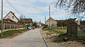
Street view
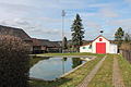
fire Department
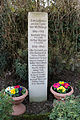
Monument "In memory of the victims of the world wars"


Personalities
- Karl Gustav Hesse (1795–1851), doctor and writer in Wechselburg
Web links
Individual evidence
- ^ Population of the municipalities from the Thuringian State Office for Statistics ( help on this ).
- ↑ Woldemar Lippert , Hans Beschorner : The Lehnbuch Friedrichs des Strengen, Margrave of Meissen and Landgrave of Thuringia 1349-1350. Leipzig 1903.
- ^ Andrei Zahn: The inhabitants of the offices of Burgau, Camburg and Dornburg. A prayer register from around 1421–1425 (= AMF series of publications. 55, ZDB -ID 2380765-9 ). Printed as a manuscript. Working Group for Central German Family Research, Mannheim 1998.
Albersdorf | Altenberga | Bad Klosterlausnitz | Bibra | Bobeck | Bremsnitz | Bucha | Bürgel | Crossing the Elster | Dornburg-Camburg | Eichenberg | Eineborn | Eisenberg | Frauenprießnitz | Outdoor orla | Geisenhain | Gneus | Golmsdorf | Gosen | Graitschen at Bürgel | Greater buckedra | Grosseutersdorf | Großlöbichau | Großpürschütz | Gumperda | Hainichen | Hainspitz | Hartmannsdorf | Heathland | Hermsdorf | Hummelshain | Jenalöbnitz | Kahla | Karlsdorf | Little buckedra | Kleinebersdorf | Kleineutersdorf | Laasdorf | Lehesten | Lindig | Lippersdorf-Erdmannsdorf | Löberschütz | Mertendorf | Meusebach | Milda | Möckern | Mörsdorf | Nausnitz | Neuengönna | Oberbodnitz | Orlamünde | Ottendorf | Petersberg | Poxdorf | Rattelsdorf | Rauda | Rauschwitz | Rausdorf | Reichenbach | Reinstädt | Renthendorf | Rothenstein | Ruttersdorf-Lotschen | Scheiditz | Schkölen | Grinding trips | Schlöben | Schöngleina | Schöps | Side rod | Serba | Silbitz | Stadtroda | St. Gangloff | Sulza | Tautenburg | Tautendorf | Tautenhain | Animal snail | Tissa | Trobnitz | Trockenborn-Wolfersdorf | Unterbodnitz | Waldeck | Walpernhain | Waltersdorf | Weissbach | Weißenborn | Wichmar | Rooms | Zollnitz