
Poxdorf (Thuringia)
| coat of arms | Germany map | |
|---|---|---|
 Help on coat of arms |
Coordinates: 50 ° 58 ' N , 11 ° 45' E |
|
| Basic data | ||
| State : | Thuringia | |
| County : | Saale-Holzland district | |
| Fulfilling municipality : | Bürgel | |
| Height : | 240 m above sea level NHN | |
| Area : | 4.04 km 2 | |
| Residents: | 91 (Dec. 31, 2019) | |
| Population density : | 23 inhabitants per km 2 | |
| Postal code : | 07616 | |
| Area code : | 036692 | |
| License plate : | SHK, EIS, SRO | |
| Community key : | 16 0 74 068 | |
| Association administration address: | Am Markt 1 07616 Bürgel |
|
| Website : | ||
| Mayor : | Daniel Voigt | |
| Location of the municipality of Poxdorf in the Saale-Holzland district | ||
  |
||

Poxdorf is a municipality in the Saale-Holzland district in Thuringia . The city of Bürgel is the fulfilling municipality .
geography
location
The place is located in a wooded area around three kilometers north of the city of Bürgel and around 10 kilometers (as the crow flies) west of the district town of Eisenberg .
Neighboring communities
Adjacent communities are Tautenburg , the city of Schkölen and Mertendorf in the north, the city of Bürgel in the east, Nausnitz in the south and Graitschen in the west.
Waters
Poxdorf is in a side valley of the tracks .
mountains
The highest elevation is the Poxdorfer Höhe ( 356 m above sea level ) north of the village .

history
Along the middle Saale valley near Jena , Tautenburg, Dornburg / Saale , Camburg and other places, castles and fortifications have been built since the 10th century, which prove the pushing back of the Slavs in the reign of the German kings Heinrich I and Otto I. A smaller castle complex - called Hausen - was also built near Poxdorf. The castle site, now a ground monument , is located about 1.5 km east of the village at the exit of the Teufelsgrund . The satellite village of the same name Hausen was also destroyed. The castle primarily served to protect two trade routes that passed east below the castle: a north-south connection (Nürnberger Straße) from Nuremberg to Naumburg / Saale and Merseburg and an east-west connection from Dornburg / Saale towards Zeitz and Altenburg . This old road also led through the Tautenburger Wald towards Tautenburg. The castle was protected by steep slopes on three sides and to the east there was a wall-moat fortification. The castle and village of Hausen are said to have been destroyed in the Saxon civil war in 1450 . In the years 1239 and 1256 the Lords of Hausen were mentioned.
With Wolfgang Kahl 1145 is mentioned as the first documentary year Poxdorfs.
Originally the taverns of Tautenburg were gentlemen over Poxdorf. After this noble family died out, the place belonged to the Electoral Saxon Office of Tautenburg from 1640/52 . With the Congress of Vienna in 1815, Poxdorf became part of the Grand Duchy of Saxony-Weimar-Eisenach and in 1822 was incorporated into the Bürgel and Tautenburg office. In 1850 the place came to the administrative district Weimar II (from 1868: administrative district Apolda ) of the Grand Duchy. The village has belonged to the state of Thuringia since 1920.
Attractions
- The Poxdorfer Church is essentially a Romanesque building, including the choir apse with a round arched window. An inscription above the southern portal refers to renovation work in 1718.
- The Poxdorfer Hang nature reserve is located on the northern edge of the village .
- The deserted castle of Hausen and the associated desertification was already affected by excavations in the 19th century, the area is a ground monument.

Village church
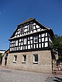
Half-timbered house

Parish hall


Web links
Individual evidence
- ^ Population of the municipalities from the Thuringian State Office for Statistics ( help on this ).
- ↑ Michael Köhler: Thuringian castles and fortified prehistoric and early historical living spaces. Jenzig-Verlag Köhler, Jena 2001, ISBN 3-910141-43-9 , pp. 129-130.
- ^ Wolfgang Kahl : First mention of Thuringian towns and villages. A manual. 5th, improved and considerably enlarged edition. Rockstuhl, Bad Langensalza 2010, ISBN 978-3-86777-202-0 , p. 224.
- ^ Karlheinz Blaschke , Uwe Ulrich Jäschke : Kursächsischer Ämteratlas 1790. Scale approx. 1: 200000. Gumnior, Chemnitz 2009, ISBN 978-3-937386-14-0 , p. 34 f.
- ↑ Bürgel at www.geo.viaregia.org .
- ↑ Geographical overview of the Saxon-Ernestine, Schwarzburg, Reussian and adjacent lands. Perthes, Gotha 1826, p. 53 .
- ↑ Locations of the administrative district Apolda in the municipality register 1900
Albersdorf | Altenberga | Bad Klosterlausnitz | Bibra | Bobeck | Bremsnitz | Bucha | Bürgel | Crossing the Elster | Dornburg-Camburg | Eichenberg | Eineborn | Eisenberg | Frauenprießnitz | Outdoor orla | Geisenhain | Gneus | Golmsdorf | Gosen | Graitschen at Bürgel | Greater buckedra | Grosseutersdorf | Großlöbichau | Großpürschütz | Gumperda | Hainichen | Hainspitz | Hartmannsdorf | Heathland | Hermsdorf | Hummelshain | Jenalöbnitz | Kahla | Karlsdorf | Little buckedra | Kleinebersdorf | Kleineutersdorf | Laasdorf | Lehesten | Lindig | Lippersdorf-Erdmannsdorf | Löberschütz | Mertendorf | Meusebach | Milda | Möckern | Mörsdorf | Nausnitz | Neuengönna | Oberbodnitz | Orlamünde | Ottendorf | Petersberg | Poxdorf | Rattelsdorf | Rauda | Rauschwitz | Rausdorf | Reichenbach | Reinstädt | Renthendorf | Rothenstein | Ruttersdorf-Lotschen | Scheiditz | Schkölen | Grinding trips | Schlöben | Schöngleina | Schöps | Side rod | Serba | Silbitz | Stadtroda | St. Gangloff | Sulza | Tautenburg | Tautendorf | Tautenhain | Animal snail | Tissa | Trobnitz | Trockenborn-Wolfersdorf | Unterbodnitz | Waldeck | Walpernhain | Waltersdorf | Weissbach | Weißenborn | Wichmar | Rooms | Zollnitz