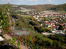
Tautenburg Forest
| Tautenburg Forest | ||
|---|---|---|
| location | Saale-Holzland-Kreis ( Thuringia ) | |
| part of | Ilm-Saale- and Ohrdrufer plate , Thuringian basin (with edge plates) | |
| Classification according to | Handbook of the natural spatial structure of Germany | |
|
|
||
| Coordinates | 50 ° 59 ′ N , 11 ° 43 ′ E | |
| rock | Shell limestone | |

The Tautenburger Wald , also Tautenburger Forst , is a forest area northeast of Jena in the Saale-Holzland district . It is named after the municipality of Tautenburg .
location
The Tautenburger Wald is the north-eastern end of the Ilm-Saale-Platte , which on the right of the Saale is distinctly broken up into individual mountains due to linear erosion . The hills originally formed a closed high plateau with the Wöllmisse , the horseshoe and the left hall parts of the Jena plaice . The elevations of the Tautenburg Forest, east of the Saale and north of its tributary tracks , consist mainly of shell limestone and are the location for the Thuringian State Observatory Tautenburg, which was built in 1957 . The northern boundary of the natural area can only be seen with the naked eye at the transition from forest to arable land and is located slightly south of the Wichmar - Schkölen - Heideland line . The Hermundurian plaice, covered by layers of loess , begins here .
history
The Tautenburger Wald had been in the possession of the taverns of Vargula since 1244 , whose Tautenburg branch then called themselves "Schenken von Tautenburg", they were also the most important rulers in the Dornburg area .
When in 1342 the Dornburg portion of the holdings of the Tautenburg Schenken was bought by the Counts of Schwarzburg , insufficient documents were issued by the officials involved, which in the 18th century still resulted in "errors and confusions". In the continuation of the territorial development, the forest area between Tautenburg and Dorndorf remained subject to an ongoing process of sales and inheritance.
Dornburger share:
- In 1357 the Wettins established the " Amt Dornburg " as rulers
- 1485 is firstly as a result of the Saxon division Dornburg in the possession of the Albertiner but then, in an area 1547 exchange the possession of the Ernestiner transmitted, it turns the Duchy 1572 Saxony-Weimar to
- In 1603 the country was divided and the area was added to the Duchy of Saxony-Altenburg
- 1672 after the death of the line Saxony-Altenburg, it falls Saxony-Jena to
- 1691–1741 it was again assigned to the Duchy of Saxony-Weimar, from 1741 to the Duchy of Saxony-Weimar-Eisenach and from 1815 to 1918 to the Grand Duchy of Saxony-Weimar-Eisenach.
Tautenburger share:
- initially the rest remained in the possession of the taverns of Tautenburg, which were under the feudal rule of the Albertine duchy
- from 1547 under the feudal rule of the Albertine Electorate of Saxony
- after the extinction of the taverns of Tautenburg 1640 Electorate home fell and in 1652 the Saxon Office Tautenburg slammed
- from 1657 briefly belonged to one or more sub-states (in common administration?)
- then to 1718 to Saxony-Zeitz duly
- from 1718 again directly belonging to the Electorate of Saxony
- from 1815 - assigned to the Grand Duchy of Saxony-Weimar-Eisenach as a result of the border corrections at the Congress of Vienna .
The topographically inadequate border descriptions and vague formulations in the definition of hunting and usage rights had increasingly led to border conflicts since the 16th century, which were documented as "acorn dispute" in the court archives of the offices involved. The name is explained by the fact that domestic pigs (referred to in the files as "tame pigs"), cattle and other domestic animals were brought into the disputed forest districts and was derived as customary law from old feudal contracts of the Tautenburg taverns. The opposing side then reflexively invoked the corresponding legal positions of their manors. The dispute escalated several times, with in some cases forest rangers and forest rangers were also taken hostage. Most of the time, however, only the acorns collected in baskets and sacks were confiscated by the border patrols, often combined with beating up the border crossers (as a deterrent, according to court files!). The individual rulers asserted the individual legal positions with disinterest, as the conflict was not considered to have any economic significance. The dispute smoldered for over two centuries and mostly flared up again with the change of a bailiff, chief forester or a change in territorial affiliation. In 1728 they finally agreed on a jointly financed demarcation with "petrification". The controversial rights of guarding and use of forest grass in the Tautenburg Forest were also newly regulated by the respective neighboring towns.
After Walther Pflug , the Varus Battle took place here.
mountains
The most important mountains and elevations of the Tautenburg Forest in the narrower sense and the entire Muschelkalkplatte are in terms of height:
- Middle fields (359.7 m), south of Rockau (Schkölen)
- Poxdorfer Höhe (356.0 m), north of Poxdorf
- nameless knoll (approx. 345 m), south of Tautenhain
- Pfennigsberg (324.3 m), south of Frauenprießnitz
- Hohe Lehde (319.0 m), north of Golmsdorf
- Hankelsberg (276.9 m), south of Steudnitz
Web links
- Tautenburg Forest
- Map (PDF; 967 kB)
Individual evidence
- ^ Siegfried Claus: The acorn dispute between Dornburg and Tautenburg in the 16th to 18th centuries . In: Sheets of the Association for Thuringian History . Issue 14. Jena 2004, p. 11-16 .
- ^ Siegfried Claus: Use of forest grass in the Tautenburg Forest after the Seven Years' War . In: Sheets of the Association for Thuringian History . Issue 14. Jena 2004, p. 16-17 .
- ↑ Map services of the Federal Agency for Nature Conservation ( information )

