
Nausnitz
| coat of arms | Germany map | |
|---|---|---|

|
Coordinates: 50 ° 56 ' N , 11 ° 44' E |
|
| Basic data | ||
| State : | Thuringia | |
| County : | Saale-Holzland district | |
| Fulfilling municipality : | Bürgel | |
| Height : | 220 m above sea level NHN | |
| Area : | 1.43 km 2 | |
| Residents: | 88 (Dec. 31, 2019) | |
| Population density : | 62 inhabitants per km 2 | |
| Postal code : | 07616 | |
| Area code : | 036692 | |
| License plate : | SHK, EIS, SRO | |
| Community key : | 16 0 74 061 | |
| Association administration address: | Am Markt 1 07616 Bürgel |
|
| Website : | ||
| Mayoress : | Bärbel Bauer | |
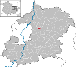
| Location of the municipality of Nausnitz in the Saale-Holzland district | ||
  |
||

Nausnitz is a municipality in the Saale-Holzland district in Thuringia . The city of Bürgel is the fulfilling municipality .
Location and traffic

Nausnitz is located in the eastern part of Thuringia, about 300 m north of the federal highway 7 . To the east, about three kilometers away, is the fulfilling municipality of Bürgel , to the west, about 10 km away, Jena and, again, to the east, about 14 km away, the district town of Eisenberg . The bus line 433 (Bürgel - Jena) and 406 (Stadtroda - Jena) operated by JES Verkehrsgesellschaft mbH runs through Nausnitz several times a day. The weekend connections were discontinued with the last timetable change for cost reasons.
Adjacent communities are Graitschen and Poxdorf in the north and the city of Bürgel in the south.
history
It was first mentioned in a document on January 7, 1358. The place belonged to the possession of the Bürgel monastery and after its dissolution in the course of the Reformation in 1526 it came to the Ernestine office of Bürgel . Due to several divisions, this belonged to different Ernestine duchies . From 1815 the place was part of the Grand Duchy of Saxony-Weimar-Eisenach , which in 1850 incorporated it into the Weimar II administrative district ( Apolda administrative district ). In 1920 Nausnitz came to the state of Thuringia.
politics
In the Thuringian state elections on September 14, 2014, Nausnitz was the municipality with the highest proportion of votes from the Greens, who became the strongest party here with 27.5%.
coat of arms
Blazon : The coat of arms is divided into green and blue by a silver wave bar and shows a silver plow above and a silver mill wheel below .

The municipality of Nausnitz shows in its coat of arms above all the historical and current employment of the inhabitants of the municipality.
The plow in the upper part of the coat of arms reflects the agricultural character of the place. The mill wheel in the lower field of the coat of arms indicates the mills that once stood on the tracks of the brook , of which two are still preserved today ( cutting mill and paper mill ). The brook is symbolized by the wavy bar dividing the coat of arms.
The flag of the municipality of Nausnitz is split green and white and bears the municipality's coat of arms.
The municipality of Nausnitz was approved on December 11, 2002 by the President of the Thuringian State Administration Office to use the coat of arms and the flag.
Individual evidence
- ^ Population of the municipalities from the Thuringian State Office for Statistics ( help on this ).
- ^ Wolfgang Kahl : First mention of Thuringian towns and villages. A manual. 5th, improved and considerably enlarged edition. Rockstuhl, Bad Langensalza 2010, ISBN 978-3-86777-202-0 , p. 189.
- ^ Johann Ernst Fabri : Geography for all estates. Part 1, Volume 4: Which contains the continuation and the resolution of the Upper Saxon Circle. Schwickert, Leipzig 1793, p. 43 f.
- ^ State manual of the Grand Duchy of Saxony-Weimar-Eisenach. 1827, ZDB -ID 514527-2 , p. 121 f.
- ↑ Locations of the administrative district Apolda in the municipality register 1900
Web links
Albersdorf | Altenberga | Bad Klosterlausnitz | Bibra | Bobeck | Bremsnitz | Bucha | Bürgel | Crossing the Elster | Dornburg-Camburg | Eichenberg | Eineborn | Eisenberg | Frauenprießnitz | Outdoor orla | Geisenhain | Gneus | Golmsdorf | Gosen | Graitschen at Bürgel | Greater buckedra | Grosseutersdorf | Großlöbichau | Großpürschütz | Gumperda | Hainichen | Hainspitz | Hartmannsdorf | Heathland | Hermsdorf | Hummelshain | Jenalöbnitz | Kahla | Karlsdorf | Little buckedra | Kleinebersdorf | Kleineutersdorf | Laasdorf | Lehesten | Lindig | Lippersdorf-Erdmannsdorf | Löberschütz | Mertendorf | Meusebach | Milda | Möckern | Mörsdorf | Nausnitz | Neuengönna | Oberbodnitz | Orlamünde | Ottendorf | Petersberg | Poxdorf | Rattelsdorf | Rauda | Rauschwitz | Rausdorf | Reichenbach | Reinstädt | Renthendorf | Rothenstein | Ruttersdorf-Lotschen | Scheiditz | Schkölen | Grinding trips | Schlöben | Schöngleina | Schöps | Side rod | Serba | Silbitz | Stadtroda | St. Gangloff | Sulza | Tautenburg | Tautendorf | Tautenhain | Animal snail | Tissa | Trobnitz | Trockenborn-Wolfersdorf | Unterbodnitz | Waldeck | Walpernhain | Waltersdorf | Weissbach | Weißenborn | Wichmar | Rooms | Zollnitz