
Reinstädt
| coat of arms | Germany map | |
|---|---|---|

|
Coordinates: 50 ° 49 ' N , 11 ° 28' E |
|
| Basic data | ||
| State : | Thuringia | |
| County : | Saale-Holzland district | |
| Management Community : | Southern Saale Valley | |
| Height : | 250 m above sea level NHN | |
| Area : | 17.91 km 2 | |
| Residents: | 479 (Dec 31, 2019) | |
| Population density : | 27 inhabitants per km 2 | |
| Postal code : | 07768 | |
| Area code : | 036422 | |
| License plate : | SHK, EIS, SRO | |
| Community key : | 16 0 74 076 | |
| Address of the municipal administration: |
Dorfstrasse 78 07768 Reinstädt |
|
| Website : | ||
| Mayor : | Volkmar Manß | |
| Location of the municipality of Reinstädt in the Saale-Holzland district | ||
  |
||

Reinstädt is a municipality in the south of the Saale-Holzland district in Thuringia and part of the southern Saale valley administrative community .
Community structure
Reinstädt includes the places Geunitz and Zweifelbach as well as the Bergern district , which consists of a few houses. There was the “Zur Falkenburg” restaurant, a popular hiking destination.
geography

Reinstädt is located in the Reinstädter Grund , which extends from the west of Wittersroda to Kahla . The Reinstädter Bach flows through the village . The Thuringian Porcelain Route runs down the Saale valley . To the north of Reinstädt lies the Schönberg , south of the Hopfberg .
coat of arms
Description of the coat of arms : “Split by blue and gold; in front a golden bunch of grapes, behind a blue lily, the base of the shield covered with a wavy bar in confused colors. "
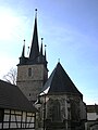
The late Gothic fortified church of St. Michael in Reinstädt ( Location → )

old grave monuments and kemenate in Reinstädt
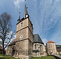
Reinstädt, fortified church and bower

Reinstädt - St. Michaelis fortified church

Interior of the fortified church of St. Michael with an unusual coffered ceiling


history
Reinstädt was first mentioned in a document from 1083 to February 16, 1084 in the Mainz deed I 365.
Very little is known about the castle, which once belonged to the bower . It existed as a noble residence as early as the 10th century. In 1083 nobles were named after the place. They testified several documents in legal transactions. The construction of the bower did not begin until 1408. The church construction was finished in 1447. After that, the owners of the property often changed up to the fiefdom of the Ernestines . The medieval residential tower was unused for a long time , then it became a granary and material store for agriculture and forestry. Today the premises serve culture and the community.
The bower, the former fortified church and the cemetery with the graves as well as the houses of the village still form a historical ensemble and thus shape the landscape.
Personalities
- Johannes Major (originally: Johannes Groß ; born December 26, 1564 in Reinstädt; † January 4, 1654 in Jena), Lutheran theologian and rector of the Jena Academy
Individual evidence
- ^ Population of the municipalities from the Thuringian State Office for Statistics ( help on this ).
- ↑ http://www.strassenkatalog.de/str/bergern-07768-reinstaedt-bergern.html
- ^ Wolfgang Kahl : First mention of Thuringian towns and villages. A manual. 5th, improved and considerably enlarged edition. Rockstuhl, Bad Langensalza 2010, ISBN 978-3-86777-202-0 , p. 230.
- ↑ Thomas Bienert: Medieval castles in Thuringia. 430 castles, castle ruins and fortifications. Wartberg-Verlag, Gudensberg-Gleichen 2000, ISBN 3-86134-631-1 , pp. 204-205.
- ↑ S. Wagner: Land market around the bower. In: Ostthüringer Zeitung , September 8, 2001.
Web links
Albersdorf | Altenberga | Bad Klosterlausnitz | Bibra | Bobeck | Bremsnitz | Bucha | Bürgel | Crossing the Elster | Dornburg-Camburg | Eichenberg | Eineborn | Eisenberg | Frauenprießnitz | Outdoor orla | Geisenhain | Gneus | Golmsdorf | Gosen | Graitschen at Bürgel | Greater buckedra | Grosseutersdorf | Großlöbichau | Großpürschütz | Gumperda | Hainichen | Hainspitz | Hartmannsdorf | Heathland | Hermsdorf | Hummelshain | Jenalöbnitz | Kahla | Karlsdorf | Little buckedra | Kleinebersdorf | Kleineutersdorf | Laasdorf | Lehesten | Lindig | Lippersdorf-Erdmannsdorf | Löberschütz | Mertendorf | Meusebach | Milda | Möckern | Mörsdorf | Nausnitz | Neuengönna | Oberbodnitz | Orlamünde | Ottendorf | Petersberg | Poxdorf | Rattelsdorf | Rauda | Rauschwitz | Rausdorf | Reichenbach | Reinstädt | Renthendorf | Rothenstein | Ruttersdorf-Lotschen | Scheiditz | Schkölen | Grinding trips | Schlöben | Schöngleina | Schöps | Side rod | Serba | Silbitz | Stadtroda | St. Gangloff | Sulza | Tautenburg | Tautendorf | Tautenhain | Animal snail | Tissa | Trobnitz | Trockenborn-Wolfersdorf | Unterbodnitz | Waldeck | Walpernhain | Waltersdorf | Weissbach | Weißenborn | Wichmar | Rooms | Zollnitz